
June 15, 2010: Cemmaes Road to Llanbrynmair
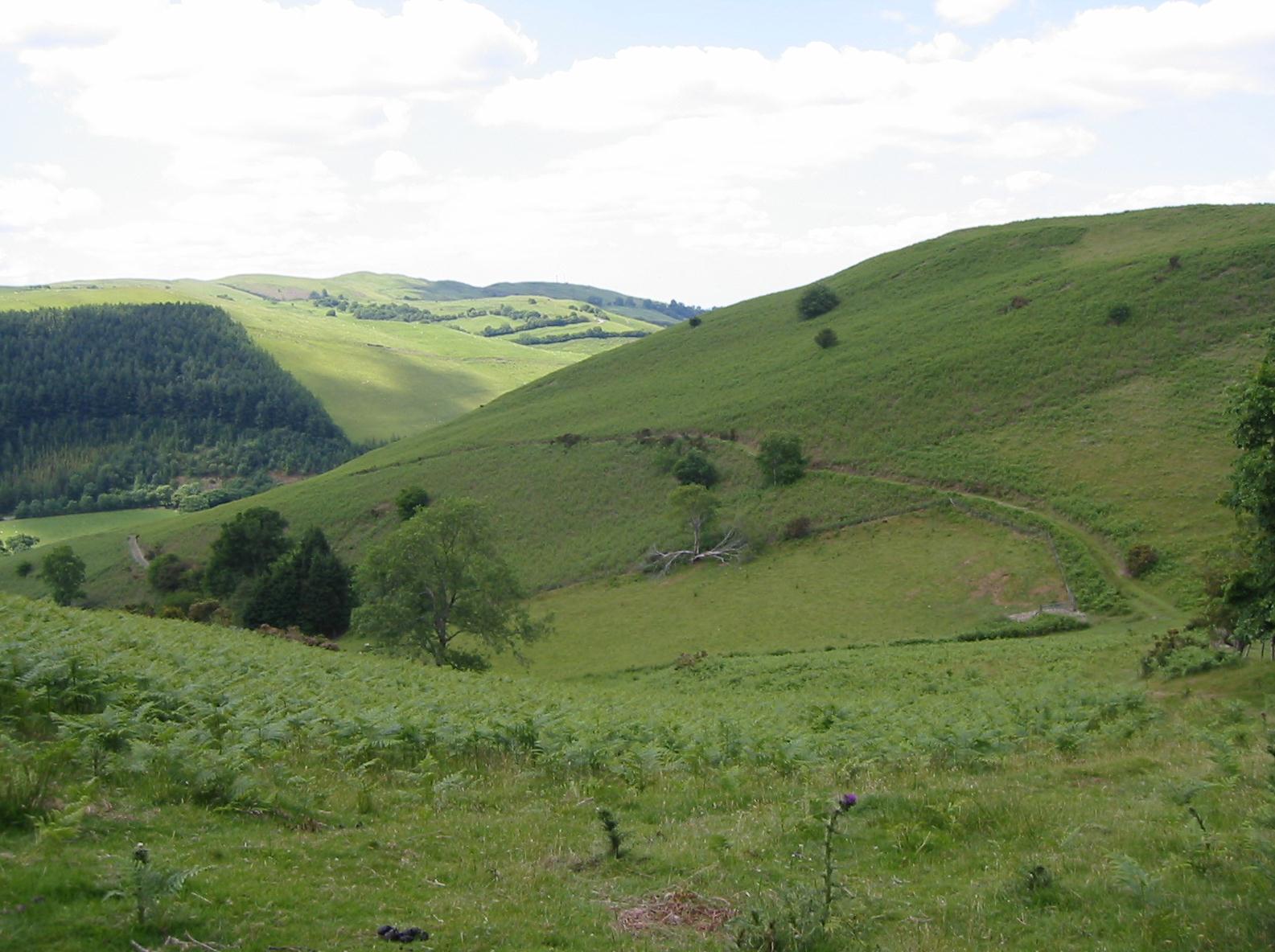
Looking southwest near Pen-y-gyrn
Our third and final Glyndwr’s Way expedition began very early on the morning of Tuesday, June 15, 2010. (Fritz had already spent a night at the home of his Aunt Hanna, and I had thus completed all my packing rituals alone as I rose at 5:00 in an empty house.) I had ordered a taxi for 5:50 and, on time, we began an early morning transit to Euston Station, already full of activity at such an hour. I had my big blue-green pack on my back and I was carrying my daypack, with walking stick enfolded within, and in this fashion I slumped down on one of the few seats provided in this concourse to wait for my June-time walking partners, Tosh Lee and Marge Rogers. Soon they arrived and set about their usual traintime rituals, coffee and snacks for the journey and, in Marge’s case, something for our lunch on the trail.
Yes, we did intend to walk today and this will explain the necessity of climbing aboard a 6:43 Virgin train bound for Birmingham International. Tosh and I had made our train reservations separately and this will explain why we were now seated in adjacent carriages. Our separation did not last for long, only an hour and a half or so. I did a puzzle and read some of my articles and in this fashion passed the time. At Birmingham International we ascended an escalator and bounced down some stairs (passing all those spots where we had waited for a similar interchange last year). Our Arriva train soon pulled in and this time we were all placed in Carriage A, though our reserved seats were occupied by interlopers. Tosh now explained that Margie had not brought a valid senior railcard with her and that she had thus been required to pay a £50 surcharge! Train speeds slackened as we made our way west, the hills beginning shortly after Shrewsbury, where the train reverses direction. It was lovely to be back in the green countryside and encouraging to note the prevalence of sunshine. At 10:45 or so we arrived in Machynlleth.
Here we were met by Mrs. Hughes, our first landlady – whom I had advised of our arrival time only yesterday. (Once again, with the Morgans of Llanidloes having retired from the b&b business, we were relying on the excellent services of Celtic Trails for our accommodation booking and bag transport.) The lady in question was looking for a trio but she was disappointed in this quest since Tosh had to sneak into the loo and Marge went to the ticket office to see if she could buy a senior rail card – the office was closed!
Mrs. Hughes wanted to know if we wouldn’t like to stop off first at Mathafarn Farm – but I was anxious to get our expedition underway. Her turnoff, in any event, was soon passed; it was located on the same stretch of highway that we had walked along after thrashing our way down the hillside in the last hour of the last day of last year’s walk – and this meant that we has soon arrived at the Dovey Valley Hotel in Cemmaes Road. We said we would call Mrs. Hughes when we arrived at our afternoon destination and she departed. I sat at a picnic bench and unfolded my stick, rolled up the cuffs of my walking trousers, opened David Perrott’s guidebook to the appropriate page in my map case, and waited for the ladies to emerge from the nearby post office, where they had repaired for snacks. We began our walk at 11:05.
Naturally I had spent a great deal of time studying the route in advance of our expedition – as usual trying to match up the text of the guidebook with the OS maps inside. I knew it would be easy to get lost (and perhaps I was a bit spooked by the misadventure that had characterized our last foray on this route) but no amount of preparation is a guarantee that it will all make sense on the ground. In fact I was looking forward to the challenges of this last strenuous section of Glyndwr’s Way with great anticipation – and the time had come to test our feet again.
We crossed the street to a bus shelter and headed east, the dominant direction for this trip. It took very little time for us to reach a roundabout (where the GW enters from the right) and here we changed highways for one heading northeast downhill. We passed over our railway line and a bridge over the Afon Twymyn. A drive soon beckoned on our right and we left civilization behind us at last. While I was reading aloud the first of many instructions in the guidebook (in the first two pages I had noted that there were over 50 clues on offer just to get us through two miles of countryside) two other genuine Glyndwr’s Way walkers came up. They were a senior couple who were doing the whole distance in one go and, naturally, it had taken them six days to complete a distance that had required ten days for us to accomplish. They had endured some torrential rain.
We had the company of the river and a railway arch over on our right as we gradually pulled away from the valley depths and began to pass through a series of gates. (Unusually, there were no stile crossings this morning, gates enjoying a 20-0 whitewash). We turned left into a side valley and left our original track for a much steeper green version on the left. This leveled off before too long and we descended to a dip in the valley floor and the beginnings of a steep climb up the opposite side. Half way up we paused for our first rest (and Tosh for her first snack). When I got my camera out I noticed that we were only a short distance from the waymark post (many of these today) that had served as the vantage point for the photo on page 114 of the guidebook.
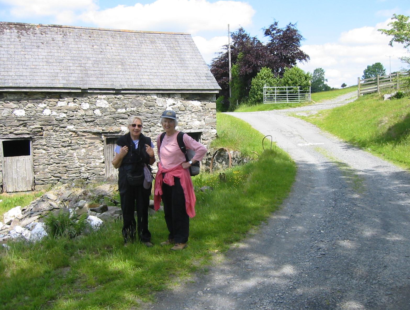
Marge and Tosh near Rhyd-yr-aderyn
We continued to climb, with some uncertainty over whether we were heading in the right direction, and, indeed, we never spotted the ruins of a long-vanished wall that were meant to serve as a landmark. We did find an appropriate waymark (usually featuring a long distance footpath acorn, a Glyndwr’s Way dragon and a directional indicator) and this encouraged us to head downhill. Soon we were climbing again, distant farm buildings helping us to measure our progress. The skies were a mixture of sun and cloud and there was always a cooling breeze up top. I wore my maroon sweatshirt throughout the day.
Our route called for us to circle the heights of a hill and from the top we could experience a marvelous panorama on all sides. Tosh had been agitating for a lunch break for some time and this seemed an appropriate place to stop. She opened her pack and recoiled in shock, the redolent tang of her homemade cheese sandwich almost knocking her over. (I had bought a chicken and sweetcorn pitta sandwich on Maida Vale Parade the day before). Lunchtime never lasted for long on this expedition and so we were soon heading down the hill, past Gwalia (where they do b&b) and thus reaching a tarmac road.
After only a short distance on this surface (during which a horse with a moustache came over to greet us) we left it to continue in an easterly fashion cross-country on a rough track to a second road. Here we turned left for a short distance, once again abandoning civilization to begin a steep climb on a dirt track that swung to the right and eventually leveled off. On such ascents the ladies often got well ahead of me. Margie was out front on this occasion and I was glad that she paused as we reached a spot above Fron-goch for here, at our four-mile mark, I knew she needed to be congratulated on completing the 700th mile of her British walking career.
We could soon see a forestry plantation ahead of us. The road through it was very wide and thus there was no need to worry about the impending doom symbolized by the darkness of some forest walks (always one of Tosh’s phobias). Again the girls got well ahead of me as we strolled along a track that descended first and then rose gently to the left. Gorse and foxglove lined the byway and I found this stretch to be delightful. I discovered the ladies waiting for me at a track junction and I reminded Tosh that she now needed to look for a right-hand turnoff as we headed left. Forest turnoffs are always tricky but the spot was well marked and we were soon bouncing along a rather spongy and more enclosed track that brought us out to the eastern side of the trees.
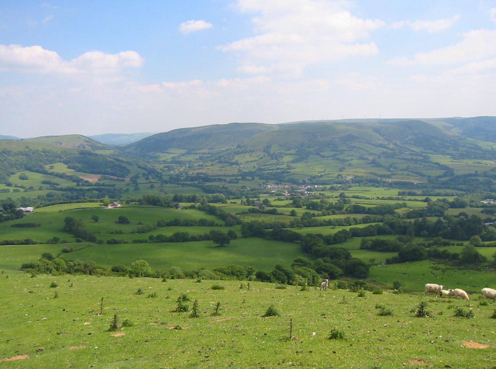
A distant view of Llanbrynmair
After passing through a gate we turned right and followed the forest fence along a ridge – where I was able to announce that we were completing the last ascent of the day. I couldn’t get Tosh to veer away from the comforts of the fence, though the guidebook says we have to do this when the trees end, but eventually I spotted a waymark post off to our left and we crossed some rough grass to reach it and begin our descent. This was a long and steep section (which I took quite slowly), having advised Tosh to head to the right of a large radio mast about half way down. From here we continued to descend, at last reaching a more level and comfortable surface as a series of lanes lead the way forward.
We were back in farming country now (just animals, not crops in this part of Wales) and we passed several flower-bedecked farmsteads as we headed south. Celtic Trails had warned of three alterations to the route since the publication of the guidebook and as we neared our destination village, Llanbrynmair, we encountered the first of these. It used to be possible to continue forward over a level crossing and thus reach the main street of the village. But there had been a fatal accident here (an American woman, we were told) and the crossing had been closed and a new road that paralleled the railway line constructed instead. This required a long eastern diversion and as we marched along the road we could see that farmers were gathering their sheep together for a trek along this same surface – using their farm vehicles rather than dogs, to get the job done. We hurried along, not wishing to be overtaken by this lot, reaching another road and turning south to pass under a railway arch and thus reach the village’s main road. At this corner we discovered the local pub (closed) and two farm lads preparing to stop traffic as the flock approached. We had walked seven and a half miles and it was 4:20.
On our right was a café and gift shop that offered the unusual attraction of a landscaped castle and lawn for rabbits. Machinations, for so the place was called, also featured a large variety of wooden mechanical toys, the brainchild of the founder of this enterprise, and these were all whirring away amid a great clatter of machinery. I had a Diet Coke and Margie a cappuccino while Tosh phoned Mrs. Hughes. In fifteen minutes she had arrived – just as well since the staff were closing down the place for the day. By now we had learned that it is easier to herd sheep than rabbits, for all the bunnies had to be shooed into safer nigh-time quarters and many were unwilling to cooperate.
As we returned to Cemmaes Road Mrs. Hughes told us something of her b&b enterprise, which not only catered to the walkers who used her hostelry in the hamlet of Llanwrin – but also to fishermen in search of sea trout. Mathafarn house was a very handsome ivy-covered structure that had reputedly played host to Henry VII on route to the battle of Bosworth. We each had a room here and we had soon showered and made ourselves respectable.
Evening meals were not on offer here so shortly before 7:00 we were driven up to the village of Cemmaes itself for a repast at the Penrhos Arms. Tosh and I had double Jack Daniels on the rocks to start with and then I had a pint of lager to accompany my chicken curry – the latter was also Margie’s choice. Tosh was quite amused by our solicitous hostess – who reminded her strongly of Alison Steadman in Mike Leigh’s Abigail’s Party. We had some yummy desserts and then Mrs. Hughes was summoned once again. I’m sure it wasn’t even dark before I drifted off to sleep after a very successful opening day.
To continue with the next stage of our walk you need:
Day 12: Llanbrynmair to Llangadfan