
June 10, 2009: Clywedog Sailing Club to Glaslyn
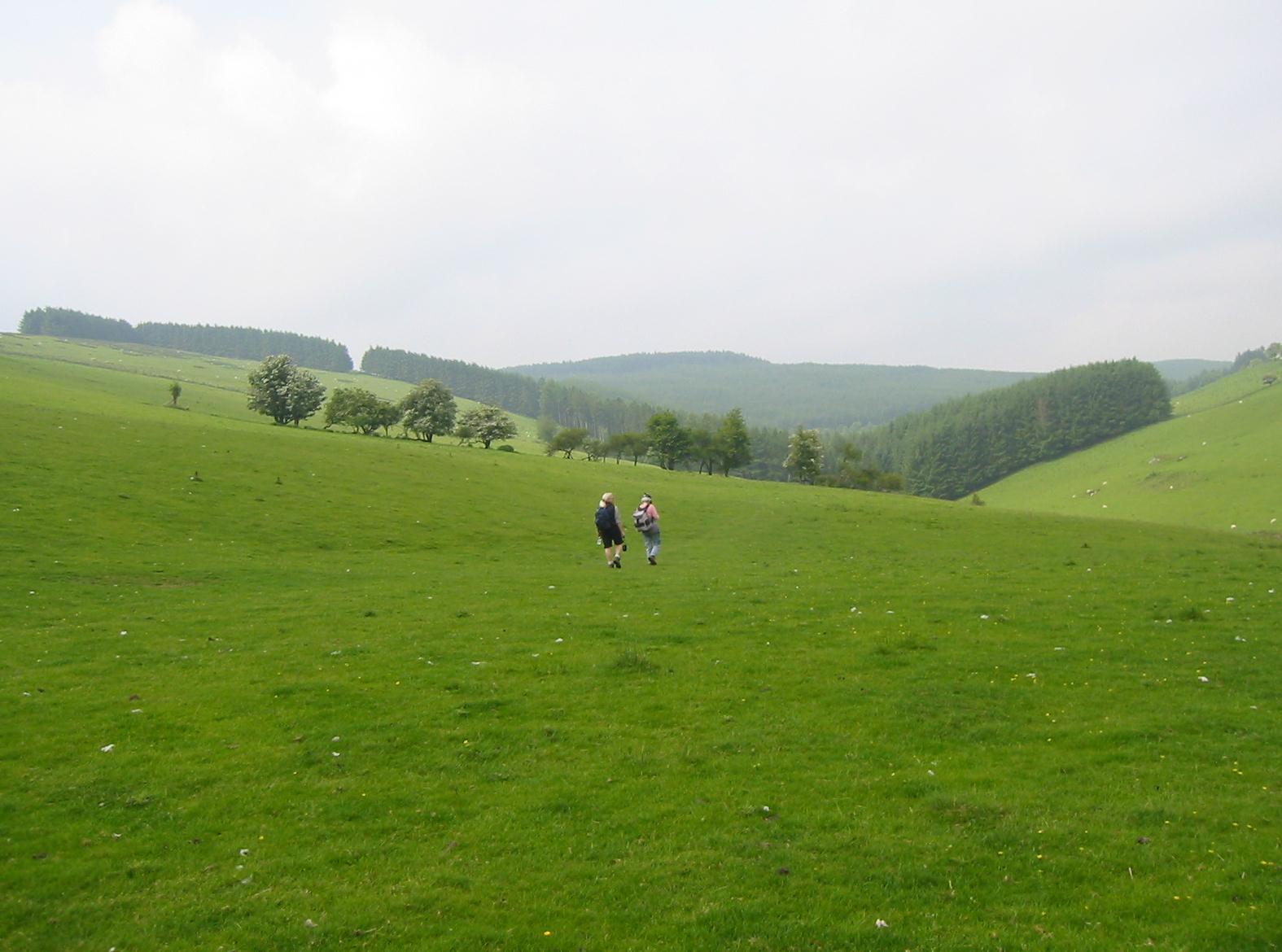
After turning our backs of the Clywedog Reservoir we approach a forestry plantation.
The long-dreaded rain had still not appeared as we to readied ourselves for the second day of our four-day walking expedition. Breakfast was at 8:30 this morning and we managed to complete our sandwich purchases well before this event – Tosh had ordered a copy of one of the quality broadsheets from the newsagent next to the Spar market and this had to be retrieved too. Angela brought news with the morning coffee: two baby jackdaws had to be rescued because they had fallen out of the nest and into a narrow gap unreachable by their anguished parents. Gareth Morgan appeared in a lovely blue pinstriped suit. He was wearing a red tie and boasting a red pocket square – “just to tease the Tories,” he said. (In fact he is a stalwart of the local Lib Dem political scene and was quite depressed about the outcome of the European Parliamentary elections concluded the previous week.)
Driving duties this morning were taken over by David Moxon, who had been our chauffeur when we were here last year. Because of my leg problems on that trip it had been suggested that we ought not start at any place requiring steep ascents and so Dave had driven us to a lay-by near Glaslyn (with accompanying Millennium Milestone supplied by those rascals at the Royal Bank of Scotland). This lake would be our destination today as we attempted to fill in the last of our GW gaps. The distance was nine miles but we were getting an earlier start than yesterday and I now added an hour to our pickup time, asking Gareth to look for us at 4:00.
Our trip to the Sailing Club (not quite half way between Llanidloes and Glaslyn but chosen in the planning stages as more likely to have some shelter in case of rainy weather) got off to a slow start. This is because Dave had to show us the registration plate of his own car, “MOX1E.” It turns out that there is a soft drink of this name in the States (indeed one even older than Coke) – and one that has a worldwide cult following – and Dave insisted that members of the group would envy him his prize, for which he had once paid £1200. He now posed for us in front of his vehicle in the parking lot of some local housing estate and we were off at last, repeating yesterday’s journey under grey skies. Dave told us all about his recent trip to Sharm-el-sheikh and his last stay in Thailand as we sped along. I got out to open a gate just above the sailing club and at 9:40 we were ready to begin our trek.
We walked back up the road a short distance and passed a cattle grid before using a stile to reach our path. The way now resembled the ups and downs and ins and outs of yesterday’s route to the sailing club, but we were even more dependent on useful instruction and well-placed waymarks. I can’t say that it was always easy to see a route in the grass and after we had cleared the ruins at Foel we couldn’t find any sure way forward, floundering around for a while before locating our next waymark. As we began a descent of the Pen-y-rhynau promontory the sun actually made a brief appearance. When we reached a level track we turned left, leaving our close association with the reservoir and crossing a road.
Our westerly route across open fields was now quite exposed but at least we were able to retain our elevation as we passed through some tree breaks and began a descent to a stream that issued from the dark patch of forestry that had been looming before us for the last fifteen minutes. The guidebook mentions the need to ford the stream but a nice wooden footbridge had been added and we were soon at the dark doorway of the woods.
Tosh is afraid of dark forests but a half right on a clear path brought us up to an open space fairly rapidly, and we now kept the trees on our left for a while, eventually crossing the grass to climb up to a gate and onto a nice level roadway, one we could use to continue our western direction for some time (longer than one could predict from the OS sections in the guidebook; could a section be missing here?). Wildflowers bloomed on the verges of the path and it was all quite lovely as we approached a farmstead below – in spite of the darkening skies above. Another section of forestry lay ahead as we shifted to a more northerly direction but there were no problems under foot until we emerged onto broken moorland, where boggy patches had to be dodged as we began a major descent.
It was not always easy to see any path in this open space but it was clear where we had to go so I improvised my own route down to a gate and then waymarks lead us up to and around the left side of the farmstead at Afon Biga, where sheep were thick in their pen. We crossed the river on a bridge and passed some picnic tables before turning right into more forestry. Or so it should have been – but the right side of the trail had been harvested and the remaining path was full of uneven surfaces. Eventually our route joined a paved road, also heading north, and footing was very much improved as we enjoyed the rest of the woodland canopy.
Surfaces may have improved but this was not the whole story for now, after two hours on the march, rain – accompanied by the constant rumble of thunder – began to fall. We sat down at the roadside and pulled on our rain gear; I was having the usual struggle getting my legs into my rain pants. The hood of my jacket was now wrapped over my Michigan Film Office baseball cap and we continued down the road and out of the last of the Hafren Forest. We were sharing a roadway that also carried National Cycle Route 8 but there were no cyclists today. We passed a weather station and took a bridge over the Afon Lywd, climbing still on tarmac, until a track beckoned us forward.
Tosh was beginning to agitate for a lunch stop as we neared a farmstead where our route takes evasive action, going around the perimeter of Nant-yr-hafod rather than penetrating this space – a gesture this lady found difficult to understand. She sat down on a log here but there was really no protection from the rain and, under any circumstances, I wanted us to reach the next line of conifers, ones that snaked down the hill a short distance away. I hoped for better shelter here but there was also symbolism involved – since the spot would mark the four-mile mark. Before reaching it we had to scramble over several farm fields and march through some tall wet grass. As often happens, access to the woodland was prevented by fences, but I opened a gate belonging to Llwyn-y-gog farm and we climbed up against a fence where an overhanging beech tree provided some relief from the moisture. We did not linger for long over our sandwiches – mine an egg mayonnaise today – and after fifteen minutes we were off. I was already beginning to worry about the possibility of our missing the 4:00 rendezvous.
The rain was still coming down and I had tweaked a calf muscle on my right leg so I was not in the cheeriest of moods as we straightened ourselves up for a resumption of the walk. I told the others to wait for me at the farmhouse while I had a quiet pee – one or the other of us was always announcing that we were hanging back for such an activity on this trip. Our direction remained a northerly one with lots of field crossings, short rises and equally brief descents as we used existing tracks to make our way forward. Soon, however, we followed waymarks off steeply to the left and entered a rounded green lane, one that rose sharply toward the skyline; the lane seemed to go on forever as it narrowed near the top. There was still more climbing when we were released to cross several fields on the way to a summit fence. We had ascended the great ridge that stands high above the valley where, unseen in the distance, the village of Dylife (with its Star Inn) lies.
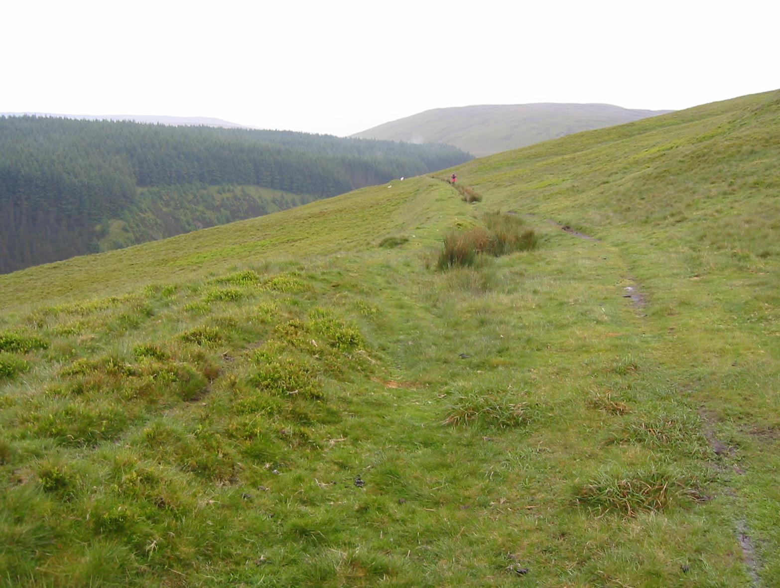
The trail rises high above the Afon Clywedog.
Thunder continued to rumble but at least there was no lightning (another thing that Tosh is afraid of) and visibility was good. Moreover, though we continued to rise on the fenceside track, the angle was far more humane and we did better against the clock than on many a recent mile. We passed a turnoff to Dylife and kept our altitude over the summit of Pennycroben, where perhaps we sighted the vague outlines of a Roman fortlet. A TV aerial was our next landmark and we could descend a little at this point, taking a dogleg to the south to reach a road that wound around above the cwm of the infant Afon Clywedog. We were directed to climb up from the track before long and pressed forward with the company of a grassy bank on our left for almost a mile. The walking was fairly easy and at least the skies to the west (our direction) were brightening. A descent began as we drew down to the river level, with deep forestry still our accompaniment on the opposite side of the valley. There were lots of mining slagheaps about and even a little waterfall when we reached the bottom and crossed a bridge.
Now we had to struggle up to a roadway and turn left, abandoning this surface for a track past some mine debris before returning to the road and searching out a turnoff onto the moorland ahead. This was located and we began a very wet slog forward, rewarded at last by our first sight of Glaslyn itself. Tosh was most reluctant to get her boots wet in the marshland on its margins but I plodded on directly to the hard surface of the lakeside road – where we could see a parked lorry. Ahead of us was the massive peak of Foel Fadian, already part of the territory that we had covered last year. There was plenty of water on our track and evasive action had to be taken to get around some of the huge puddles.
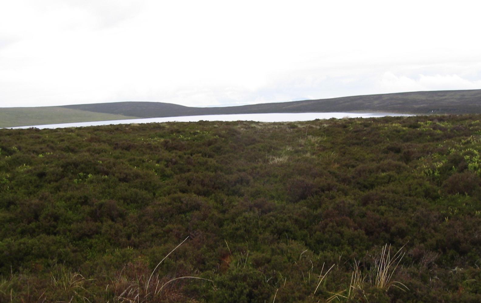
Glaslyn
At last we reached the little track that we had walked along to begin last year’s stroll to Talbontdrain and here, at 3:50, we turned off to head for the road where we had agreed to meet Gareth Morgan. Light rain continued to the end. I was surprised how far away the highway seemed now but we persevered at some pace and only a few hundred meters from the Millennium Milepost we could see Gareth inching his way down the track in his car; still in his red tie (as ordered by Tosh) he had come looking for us, as he had promised to do. He turned the car around and we got in and, very relieved to have succeeded on such an unwelcoming day, we relaxed for the ride home. Again we passed a number of spots remembered from last year: Dylife, Staylittle, the reservoir, Van, etc.
Back in Llanidloes we agreed to meet at 6:00 but Tosh was off on an errand and (after my shower and nap) so we did – having drinks this time at the Crown & Anchor on Long Bridge Street, an ancient hostelry with a resident Westie. I ordered a Jack Daniels and a lager and Tosh told us that she had bought a painting from a local artist named Julia, something bright and cheerful (Modigliani for ten year-olds) that she had seen on the walls of a local café. The usual debate now had to be held on the subject of where to eat and it was decided to try the Hafren Bistro again, a spot we had visited last year. It had been closed on Monday and Tuesday nights.
The weakest of lighting provided the backdrop to our repast in a place that passed for haute cuisine in mid-Wales. Tosh and I continued with our beer drinking, this time Czech Budwar, and I ordered the sausage in gravy. There were apologies for the unusual shape of this object but I was more disappointed by the overly wine-soaked sauce. Tosh shared a bread pudding dessert with the rest of us and we headed for home. I was asleep by 9:00.
It will be recalled that, having skipped part of the route, we did walk the stage after Glaslyn in 2008. To continue north from this lake, therefore, you need: