
June 26, 1999: Kirkby Stephen to Frith Lodge
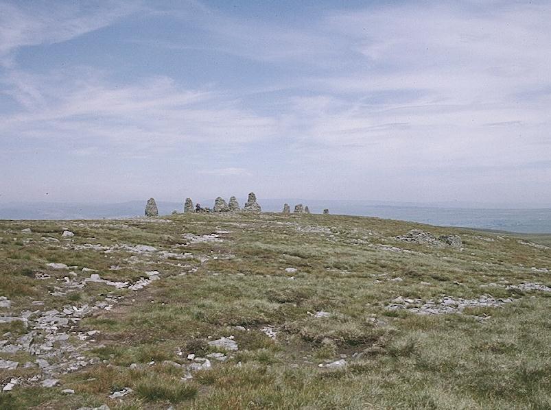
The Nine Standards
From our b&b breakfast room you could actually see our next objective, the Nine Standards, tiny needles indenting the eastern sky atop the Pennine crest in the clear air of this Saturday morning – another radiant start to a day of walking. Because we had to get our packs back to the youth hostel by 9:00 we had asked for an 8:00 breakfast, which was served to us by Mike Bell, a military presence who saw quickly to our simple requests. I was already warm sitting in the window at our little table. I used the mobile phone to speak to our next landlady, whose brochure mentioned that she would pick up packs from the Keld Youth Hostel. This she agreed to do.
We began our walk back up the street at 8:40 and had soon deposited our gear in the bike shed. Then we split up for a few minutes. I took a photo of the temperance hall and had a chat with the Rugby duo. Harold and I both ended up at a market where we bought more liquid and some food for our lunch. Across the street, at the MegaBite, a shop lady was waiting for the baguettes to cool while we placed our sandwich orders. Tosh sat outside on the pavement reading the newspaper. Harold and I lathered up with sun block and by 9:20 we were ready to make our departure at last. Then Tosh decided to use the village loos one last time.
An alleyway lead us down to Frank’s Bridge, where we crossed the River Eden. A tarmac ribbon led us gently uphill to the village of Hartley, an idyllic place this morning with its cool shade trees and flower-festooned cottages. A turn to the right, a beck crossing and the rounding of a steep road corner put us at the entrance to the huge Hartley Quarry – which would now dominate the scene to our right. The Lees were soon well ahead of me, not only because of the steepness of the gradient but because I was pausing now and then for liquid and photos of the Vale of Eden below. One was never alone for long, however, for a stream of C-to-C walkers and day-trippers were following the route as well.
The road turned to the right above the quarry and continued to climb until a delightful side valley, containing the farmstead of Fell House, offered a brief descent. Then the road climbed some more, giving way at the end to a rough track – at a turnoff point where walkers were expected to leave its smooth surfaces. Here we had a bit of a rest. Accompanied by stone walls on our right we continued to climb fairly steeply, with the Nine Standards often in view above us, until we reached the trickle that was Faraday Gill today. (I had the impression that moisture levels had been fairly low recently.) The route continued to cling to a stone wall on our right for some time, then abandoned it to parallel the gill. At a sheltered spot above a sheepfold I found Tosh having a rest. It was certainly true that the weather pattern was shifting. There was a strong and cooling wind up here and the skies were more overcast. Visibility was still excellent, but no one thought of using sun block any more on this day.
I was amused by the hard ribbon of brown earth that eased the walkers way right up to the nine famous cairns (Tosh always called these stone monuments “carns”). What had once been a juicy struggle to the top had been smoothed into submission for the benefit of the legions who now made this pilgrimage. “They should call this the Wainwright Memorial Highway,” I told Tosh. It was noon.
We walked around the standards for a while and took some pictures, then headed past a ruinous shelter on not much of a path to the summit of Nine Standards Rigg itself – at 2171 feet the highest point on our route this trip and the real dividing line between the east and west of England. Indeed, I had promised the Lees that they could now enjoy downhill all the way to Keld, but as we descended to the hag-ridden morass that separated our summit from White Mossy Hill I noticed that none of the other walkers were taking the left turn for Whitsundale!
Signs now announced that because of erosion C-to-C walkers were to continue south on the ridge top, using an alternative route. Had I owned a copy of the special Outdoor Leisure Map to the western half of the Coast-to-Coast route I would have known that we were now meant to use the “summer route.” I did of course know something about it – for the summer route was obviously going to follow Wainwright’s original Ney Gill descent, a route that had been abandoned, so my edition of Hannon informed me, because of erosion on it!
So it was a bit disconcerting to be walking for a while without a guidebook at all, though I remembered Wainright’s original suggestion that the escape route would be to continue in a southerly direction all the way to the B6270 road to Keld. We did have other walkers to watch, first as they struggled up White Mossy Hill and then as they pressed forward from hilltop to hilltop, often with nothing more than a guidepost to offer some hint as to direction – and no real path to follow among the tussocks of heather and the inevitable wet peaty patches. It was not easy walking, but I was really glad I had my stick with me, for I could test the depth of surfaces with it and rely on it for assistance in gaining purchase in those desperate boggy places.
Tosh had been complaining about hunger for a long time and so, when we reached the stones on the crest of Coldbergh Edge, we found a sheltered spot among the boulders and, in a little watery sunlight, opened our lunches and dived into our baguettes. Mine was tuna and mayonnaise. Ahead of us we could see the cars on the B6270; they still seemed to be a long way away. The wind was very strong and I was antsy to see if I could spy out a continuation of our route, so I told the Lees I would meet them at the next guidepost and headed off early for this viewpoint. Here I met a chap (who had done the whole route 20 years earlier) with the right map – and he confirmed my suspicions about our now being on the original route. Far below us we could see walkers at last reaching an easterly turnoff. The Lees came up behind me and we descended to a dirt road, where a C-to-C sign confirmed that we had not been lost at all.
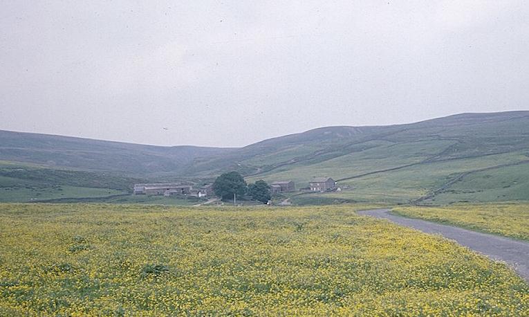
Ahead of us was a shooting hut and, as we were soon accompanied by a beck on our right, I assumed that we had at last reached Ney Gill. Numbered grouse butts on our right confirmed this – for Hannon had included this detail in his maps and we were thus once again guidebook-centered. We had another rest near a crossing of the stream, where a party of four young men came up behind us; I was able to predict to them that they would soon cross the stream a second time. There seemed to be two routes available as the gill plunged between stone fences; both of them required some climbing to reach a height overlooking Raven Seat, a wonderfully situated farmstead near the confluence of Whitsundale Beck and Ney Gill. Yellow wildflowers were spread out like a carpet before us as we climbed down to a cattle grid and headed north on a farm road.
Raven Seat
From the farm yard we proceeded downstream, first well above Whitsundale Beck and then above the Swale itself. There were quite a few stiles about and I had some difficulty with them, especially when the Lees weren’t about, since the camera often slipped from my right shoulder at such moments, often crashing to the ground. At that I noticed my tape job on the camera case was now coming to an end of its useful life and I had to borrow some white adhesive from Harold in order to do a patch job.
Swaledale was wonderful, of course, and once I called Tosh back to see a thundering cascade behind us. The weather was also improved, with much milder temperatures than on top and even the return of some sunshine. As we were making our way along muddy and rocky narrow paths on Catterby Scar two guys came up behind us with a sheep dog, the only time I can recall seeing anyone walking with a dog on this trip. Keld Youth Hostel came into view on the opposite bank, Kisdon was straight ahead, and I was beginning to see well-remembered sights from my Pennine quest of many years before.
We reached a road and descended to Park Bridge, intending to continue on to the village and visit its shop before using the Pennine Way to reach our b&b, still over a mile away and many feet above us. It was closing in on 5:00. We got no further than the Park Bridge Campsite – where a sign confirmed that Keld no longer had the shop I remembered using 23 years earlier. The same sign informed us that various refreshments could be obtained at the cottage on our left so we waited around for the proprietor to reappear, chatting in the mean time with some chaps who were here to supervise kids out to earn their Duke of Edinburgh awards.
The Lees ordered coffee and I drank a cold Diet Coke, after refusing an equally cold Pepsi Max. Some camp kids were playing with the grey-eared spaniel, George, and the 11-month old black mutt, Jemima. Two of the four chaps who had passed us on Ney Gill arrived for b&b, also offered here, and Mr. Atkinson, I think that was his name, offered some suggestions on how best to reach Frith Lodge. He warned against trying to find the footpath from West Stonesdale and so we decided to take the Tan Hill motor road and use the farm’s own winding access road to reach our goal.
So after our rest we re-crossed Park Bridge and headed steeply uphill into the hamlet of West Stonesdale. The Duke of E. chaps were sitting in a parked car here and way above us on the opposite side of Stonedale Beck we could see the house that we assumed was Frith Lodge. It took us a long time to reach it, but in the late afternoon sun the scene was very beautiful. We found the access road without difficulty and descended to the parked taxi van of our host, Mr. Pepper. Then it was steeply uphill, behind the house and onto a track that also contained the PW. At 6:05, after a 14-mile day, we arrived at our place of refuge.
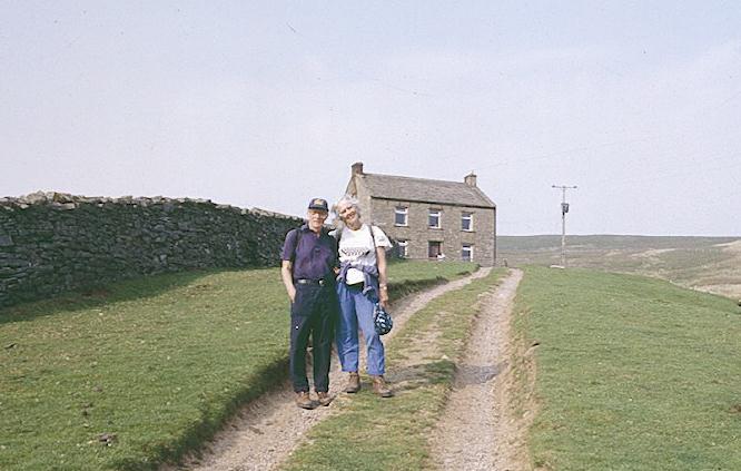
The Lees at Frith Lodge
Sheep stared dozily at us as we rang the front door bell. Mrs. Pepper asked us to use the back entrance, where we left our boots while she returned to planting onions in the garden. We were offered a nice cup of tea in the dining room and then I was shown to a bedroom, obviously recently yielded by the teenage son of the family, a room with a wonderful view down the dale. There was a narrow bed made up for me, a bunk opposite, and stuffed animals, games, war toys and portraits of the entire Manchester City football team sharing space with racing cars on the walls. The Lees had the first bath and I followed. A sign in the bathroom described the water supply (they had their own spring here) and confirmed, “You will have noticed that we are in the middle of nowhere.”
We went down to a lovely home-cooked meal at 7:30. I had bet Tosh two bits that we would be served lamb; she had opted for chicken. In the end it was turkey, fresh veg and Yorkshire pudding, with a lovely cake in custard for afters. There were two other guests at table, and we recognized them immediately – Monique and Ian. They were walking the whole route in one go, had been training for it for some time. He was a machinist in an exhaust factory and she was a quality surveyor for British Standards. They were very nice and we had obviously shared many of the same trailside experiences. Monique was quite sunburned and suffering from a bad cough.
After dinner we were joined by Mrs. Pepper (Mr. P. was out in the yard hammering on a Toyota pickup and the boy was kicking a football up against a wall.) Here we learned quite a bit about the isolation of rural life; the boy had a 26-mile journey by bus to Richmond for school. Mary had taken a course in computer skills in the Muker village hall and wanted even more – you could tell that electronics were her highway to the outside world. From her we also learned a great deal about the pack ferrying wars on the Coast-to- Coast path. In turned out, quite by accident, that Mr. P. was the van driver for much of the central section of the route for the Sherpa Company, which for £5.00 (instead of Mr. Bowman’s £3.50) would deliver your bags to your place of residence – instead of making you pick them up in a central location. We were dreading having to get up early enough to get our bags to Keld Youth Hostel, for instance, but now there seemed to be no need. We signed on with Mrs. Pepper and made arrangements on the spot for transfer of our bags by Sherpa the next two days. Tosh was even able to use her credit card. I thought for a while that Mrs. P. would never stop her recital of the route intricacies followed by the Pepper taxi on its appointed rounds nor her complaints about the way Sherpa ads mysteriously disappeared from local notice boards.
Finally we made our way up to our rooms and I closed the curtains on the magical blue grey of the scene below. I was tired and sore but also having difficulty finding a comfortable position in my narrow bed and at one point I got up to take a sleeping pill.
To continue with our next stage you need: