
June 27, 1999: Frith Lodge to Reeth
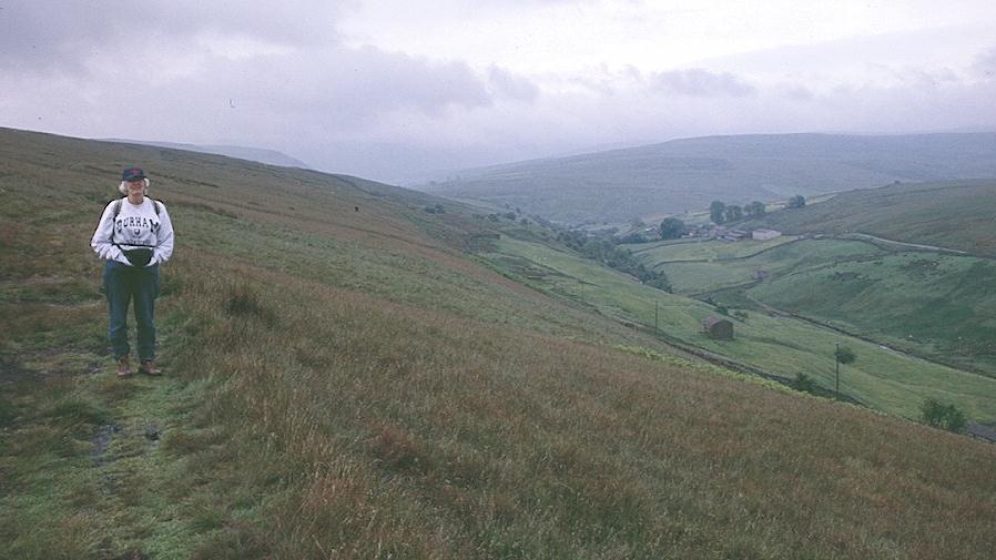
Tosh on the Pennine Way above Keld
It had been raining off and on as we arose on the fourth day of our walk – an endeavor that proved to be, indeed, one of the most memorable days in our walking careers. I now managed to put my healing arm out of alignment as I tugged on some item of equipment – the first time I had done this since the morning of our departure. As usual the panic of a suddenly rigid appendage was more alarming than the accompanying pain, and I soon rotated my wrist and pulled things back into place. Monique was just apologizing for keeping everyone up with her cough as we descended to breakfast at 8:00.
We now had the unusual sight of seeing our backpacks leaving the establishment before the rest of us, for at 9:00 Mr. Pepper threw them into the back of his Toyota and headed down the hill to his taxi van below. Mrs. P. had to manage some gates and keep an eye on the sheep – which were obviously also her pets. (Bella leapt up to greet her mistress like a large dog.) When she came back inside Mary Pepper was full of complaints about the ferocity of the midges this morning; her arms, we could now see, had been scratched red after earlier encounters with these beasts. It was misty but not actually raining when we left for a long 12-mile day at 9:15.
This time we did use the Pennine Way, though I was surprised to see us heading uphill at first. I had many thoughts about my last moments on this same path – 22 years earlier. I remembered how Jay had been disgusted by his first encounter with the manure of the farmyards and I remembered that I was using a stick then too, though gout had been the problem then. For views of Swaledale and Keld a southerly direction was the way to go on this stretch; even on this gloomy and grey day all before us was wonderfully beautiful.

Swinner Gill
By 10:00 we were at East Gill Force (the Chorley couple caught up with us here and were soon far ahead); we paused for some picture taking, then headed east over the beck and up a broad track, rising gradually as it paralleled the Swale gorge below – we were about to lose direct contact with Swaledale itself, though you always knew that every stream you crossed was somehow heading for the Swale below. I found the Lees poking around in the ruins of Crackpot Hall, a farming house made uninhabitable by mining subsidence. Our rocky track climbed up behind this site and contoured over to the flanks of the next valley, with Swinner Gill far below us and many inviting paths chiseled in the green facades of the hills opposite. We couldn’t see any of the early morning walkers on them and this was puzzling until we reached the bottom of the valley and realized that we were not meant to contour out over these green ways but to head up a steep beck that was falling to join the gill, East Grain.
There were a number of small waterfalls on our right as we climbed beside this stream, breathing heavily and picking our way carefully among the rocks of the path. At the top contours leveled out and we continued forward in moorland scenery (some of the heather had clearly been alight recently) and emerged onto a bulldozed hunter’s track where we sat down for a rest and a snack. The continuation of our path into a boggy morass did not seem too inviting so I suggested we keep to the track, which soon curved around to meet this path anyway. The Coast-to-Coast Path here uses the track for fast progress over the moortop until, at the first of many hushes, we turned left to descend steeply on path again into the confines of Gunnerside Beck – a veritable open museum of abandoned relics of the lead mining industry.
It was on this descent that we felt the first real raindrops of the morning’s walk; they weren’t heavy enough to wash away the midges, who were swarming about us now, but as the intensity of the downpour increased we paused among the ruins of the Blakenthwaite Smelt Mill to don our rain gear. My arm gave me trouble tying the chin straps of the hood of my rain jacket but I managed this, took in some water from one of the many containers I was carrying in my daypack, and followed the Lees steeply uphill to a crossing track where we turned to the right to reach the ruins of the Bunton Crushing Mill.
Here we had to abandon an inviting path that continued to contour the hillside in front of us and turn up to the left amid the hushes to reach the moor top again. I was having a lot of trouble navigating. The rain was falling much more steadily now, right into my face. My glasses were steamed up by perspiration on the inside and dotted by droplets on the outside. Eventually I took them off and put them in a jacket pocket. The Lees, who had only the vaguest notion of where we were meant to go, got well ahead of me on this ascent as well, and by the time I caught up with them they had completely lost the path itself and were looking hopelessly at me as though I had been to this green wilderness before. I pulled out my xeroxes a few times (they began to melt but they weren’t very useful anyway). I knew that we had to go up and east and so we followed a series of “paths” (probably sheep trods) uphill in the rain. Finally we ran out of any clues whatsoever. We were lost.
Ahead of us was a vast heathery moor top, boggy in parts, and not easy on the feet. There was a bulldozed track off to our left but it seemed to be heading in the wrong direction (I looked at my compass many times). So I continued forward over the wilderness, heading up and east, with the Lees loyally in tow. They seemed convinced that they would soon be sinking into some bog, but the heather was pretty springy and the feet usually found a way to move forward without sinking beneath the surface. A long wall, which I assumed to be part of the ruins of the Old Gang Lead Mines, stretched out before us and I kept it on our right as I pressed on. Finally we reached a track winding among the spoil heaps of the top. We were searching about for a way forward when Tosh heard some voices. A party of walkers had erected a shelter above one of the ruinous outbuildings and we decided to have a word with them.
A nice chap with long (and on this day) damp hair seemed to be very familiar with these parts. He confirmed we were at Merry Field and that if we stayed on the track – which was now heading downhill – we would reach Level House Bridge. “We never had to tell him we were lost,” I said to the Lees, “by the time I asked him to confirm our location we were standing on the Coast-to-Coast path!” Tosh was still in awe that I had gotten us out of our fix. “I can’t think of anyone I’d rather be lost on a moor with,” she said.
Talking to other walkers later convinced me that this is often a difficult stretch, made more so by the unwillingness of the proper authority to provide useful waymarking – which, after all, might encourage more use of these grouse hunting acres. The inevitable consequence of this malign neglect is that walkers have a much greater chance of disturbing the birds by wandering off course, as we did. Nevertheless, our happy mood restored, we marched down the hill at a rapid clip and reached the bridge in question.
Here we decided to have something to eat, though there was no shelter and so, leaning up against the bridge abutment, we dined in the rain. Still, it was good to take in some sustenance and have a rest. Suddenly there were lots of other walkers about (again including the two chaps with their Duke of Edinburgh duties) and this was reassuring.
Naturally we didn’t linger for long but continued downhill on tracks that paralleled Hard Level Gill and Old Gang Beck as the light rain continued to fall. When we were opposite Hard Level Force I paused briefly to note that I had just completed my 3000th mile on British footpaths. Tosh, who was much more excited by this achievement than I was, insisted on some picture taking and then we continued downhill past more ruined mining sites until we reached the tarmac of a road crossing Surrender Bridge.
We had some difficulties making our way forward here too. Hannon says, “Cross straight over the road and away along a clear path,” but the maps he has provided show the clear path he is referring to starting slightly up the road, not straight across it. The paths here all seemed to lead to a ruin and then to continue forward above Barney Beck and – in spite of my urgings that we needed to be off to the left, the Lees pressed forward until they were faced with the steep drop-off of Cringley Bottom – though I knew that we needed to be some distance upstream to find the right crossing of this gorge. So once again there was some improvising as we headed north along the faintest of trods until the path we were looking for came in behind us and we plunged precipitously downhill.
The descent was very steep and not easy to accomplish and I depended a lot on the leverage provided by my cane. On the opposite side of Bleaberry Gill we had an equally desperate climb to a hidden stile in a stone wall, but once we had crossed over to the other side route finding became far easier and we had no further problems on this day. We kept a stone wall on our right as we walked on tracks amid ruins and stone sheepfolds, still heading east but gradually losing elevation. The rain was intermittent now.
Tosh, having learned her lesson (for this day at any rate), paused dutifully as the tracks split at Thirns, and I looked closely at the map before confirming that we were to take the less inviting uphill fork to continue our progress. Below us we could see the grey village of Healaugh and Swaledale was once again on our right. Our track continued its descent among farm buildings and at last reached the head of Skelgate, a thin green way locked between stone walls. The surface was rocky and the route overgrown with vegetation on either side and above us as well – so that a good deal of bobbing and weaving was necessary. Although the rain had a harder time getting at us, the way seemed endless. Finally there was a sharp turn to the right and at the bottom one could see, at last, the main valley road. We were put out only a few feet from the beginnings of Reeth itself and after a short stroll into the village we located the Buck Hotel at one corner of the large green. It was 5:10.
A friendly manager showed us to our rooms on the first floor; we had en suite facilities at last. We got rid of our boots and changed out of our wet clothes (my blue sweatshirt was pretty damp but there was no heat in the radiators) and now headed directly to the bar, where, as residents, we were not made to wait for normal opening hours. Harold and I each had two double Bells to celebrate our safe arrival and my 3000th mile and each of us smoked a small Hamlet cigar as a token of victory. Then we went upstairs for a leisurely clean up, reconvening at 7:30 for our pub meal. I switched to Diet Coke and had scampi and chips again while the Lees ate steaks. No one asked us what we wanted for dessert because there next arrived a magnificent Tosh-inspired cake, congratulating me on my 3000th mile and decorated with two wonderful brown hiking boots in brown sugar. Everyone in the pub had a look, including a woman from Canada who also does cakes, and we invited some of the other walkers over to have a piece.
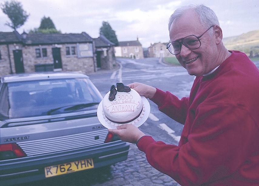
In Reeth I show off my Tosh-inspired cake
– celebrating my 3000th mile on British footpaths.
I took the cake outside to see if we could get any photos in the last of a returning sunlight and these actually did come out. However Bob Hawkins left his son with us while he went to his hotel to fetch his flash camera and he took quite a few shots, sending me some of these snaps when he and the lad finished the walk a week later. Monique and Ian were here too, so it was a jolly time. We ordered some packed lunches (they promised to include the last three pieces of cake) and then we went out in the dusk to have a circuit of the green. However we were all very tired and so it was another early night for us back at the Buck Hotel.
To continue with our next stage you need: