
July 15, 1985: Patterdale to Bampton Grange
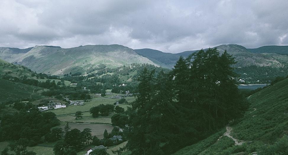
Patterdale from just below Boardale Hause
The bad weather that had caused us to alter our walking plans for August 2, 1984 had also left us with a gap in our attempt to complete the Lakeland portion of Wainwright’s Coast-to-Coast Path. The following summer, therefore, I reassembled the same crew in order to accomplish two tasks, completion of the north-south Cumbrian Way and the addition of the one missing piece of the Coast-to-Coast puzzle. We had already spent two days on the Cumbria Way when, on the afternoon of Sunday, July 14, we drove from Coniston to Patterdale in Harold’s car, arriving sometime after 5:00. From here we would once again be poised to complete the crossing of the High Street range.
The Lees ended up with the same room as last August, but our room now faced the front of the Patterdale Hotel. It had a nice bathroom, though Bertie was spooked by it, and he would only put his head into its space while eating or drinking. We had drinks in the Lee’s room before dinner and discussed what to pack for the morrow’s hike. Our memories of the cuisine at the hotel were not particularly elevated, but having prepared ourselves for the worst, I think we survived pretty well – most of us dining on the pork. As last year, the dining room was choked with Glenton tourists – two coaches worth – and food was produced on the assembly line. A lingering Tosh had to fight the impatient waitress in order to retain the last few bites on her plate.
After dinner I walked the dog as far as the parking lot in the village. The sky was still fair when we retired, but it had been so on the eve of last year’s deluge. Though determined to attempt the high level route in any weather conditions this time, I nevertheless went to bed with the usual anxieties.
I believe I had my first peek out the window at 4:00 in the morning. Dawn was bringing a day of high clouds to Patterdale, but visibility was very good. A touch of a sprinkle may also have come once before 6:00 but thereafter the clouds lifted and some sun broke through. The day would be cloudy but bright and, until near the end, without the threat of rainfall – ideal walking weather. The greatest impediment to our progress was thus overcome, and I was very relieved.
We were allowed to go into breakfast at 8:00 – along with the tour bus crowd. Before that moment we made several trips to the car in order to store everything that would not be carried on our backs over the high peaks. The hotel did not do lunches so we had stocked up on goodies at the little village store the previous afternoon. Harold couldn’t find Tosh’s wet pants, but in fact he had packed them into the bottom of his new waterproof knapsack.
After breakfast we paid our bill (quite expensive I thought) and mounted up and we actually succeeded in making our getaway a minute or two after 9:00. We walked around the corner, through Patterdale village, where Tosh posted some cards, and then we took a left off the main highway over a bridge. A tarmac road, defended by local dogs, led across the valley floor and up through a collection of cottages. A gate gave us access to the fellside and a short scramble put us onto a lateral path. We were now ready for our first ascent.
I cannot think of a day’s walk to this point that had elicited from me a more thorough preparation. I knew it would involve our greatest elevation rise, that it was full of inviting false alternatives, and that my troops would need all the encouragement possible to succeed over thirteen long miles. So I had studied Wainwright assiduously and the NE sheet of the large scale OS map of the Lakeland. I knew that we would have our steepest section earliest and that by the time we had reached the five-mile mark we could begin our descent. Harold and I had scanned the fellside where the lines of twin trails were evident – it was the disappearance of these in the mist that had caused us to pack it in last August. Now all was clear as we reached the bifurcation of the paths near the bench described by Wainwright. Tosh, leading with Bertie, was advised by me, from several yards behind, to take the lower of the two paths and we were off – or should I say up?
In the event the ascent proved far less arduous than imagined. We took it slowly, benefiting from magnificent views of Helvellyn and Ullswater behind us and Brotherswater ahead. At Boardale Hause the “maze of paths” seemed quite solvable and after an ascent along a beck and the appearance of an advertised sheepfold, we had a brief rest while I used my compass to authenticate the direction of the ascending path to the top of Dubhow Beck. Gradients were more humane and we were making excellent progress in real high mountain surroundings. The path surfaces were well graded and dry and I was extremely happy with our start.

Angle Tarn
When we reached the top of Dubhow Beck there was another division of the paths. The upper one bore the correct sign for Angle Tarn, but I obeyed Wainwright’s suggestion and we took the lower route again – a level crossing beneath crags that suddenly swings east to reveal Angle Tarn, nestled in its Sierra basin. We paused to eat some fruit while viewing this scene, a visual treat I had not warned the others of in advance. Some campers were taking down a yellow tent on the eastern shore of this dramatically indented and islanded lake. They were still at work breaking camp as we cleared their side of the tarn and climbed upward over Satura Crag.
Here, as Tosh celebrated her 300th mile, we followed a stone fence before finding a gap that put us onto a section of wet, peaty grassland – Hayeswater Reservoir now below us. The path running up the shoulder of The Knott was clear as well, but to reach it required the crossing of several raw peaty marshes and oozing becks. In such terrain the straightforward approach is always abandoned for the cautiously hopeful evasion. Each of us experienced triumphs and tragedies during the crossing but no one endured greater suffering than my fastidious wife, who greeted every sock-staining footfall with despairing curses, a language of protest so rich in invention that it brought a touch of pink to the ears of the teenaged campers who had come up from Angle Tarn behind us. She was close to tears by the time we cleared the last of this mess and settled down for a rest at the foot of our steep trail up The Knott.
Then we struggled up our last major ascent, past an ominous stretcher box and through the Straits of Riggendale. Naturally I was last up and Tosh, following the lead of the teenagers, had already started downwards on the path to High Street when I had to call her back for our turnoff. This was real Roman road country. On a day of excellent visibility, it was truly wonderful to be up here at last, though quite a chill wind was blowing. We crossed above Twopenny Crag and followed a curving ridge around to our summit, Kidsty Pike. The walking was very easy now. At 2560 feet this was a rare summit for Wainwright’s route.
We found some shelter behind rocks and sat facing Haweswater Reservoir while we had lunch and I put on my blue coat because of the wind. Crackers and cheese, pork pies and fruit came out of the lunch sack. Bertie had his dog meal soaked in his little round aluminum bowl, the one that would never settle properly in the back of Dorothy’s rucksack. People were struggling up along the long path on the eastern ridge of Kidsty Pike, with Bertie raising the alarm and now Tosh provided the comic relief. Having excused herself to find relief behind some summit rocks she returned shaking with embarrassment – “Oh my God. I just peed in those people’s faces!”
After lunch we packed up again and began the descent; we still had a long way to go. Wainwright warns that the path fades out before Kidsty Howes and that one is supposed to drop off the ridge to Randale Beck, but it was certainly not true that the path had died out. Once or twice I looked in the long grass for a descent to the beck but found none. Instead walkers kept popping up on the quite obvious path over the Howes – a route clearly marked on the OS map. So I decided to use this as our line of descent also.
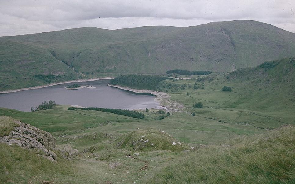
Haweswater from Kidsty Howes
It proved to be a very steep descent indeed, one requiring us to inch down rocky chutes filled with loose earth. I lead, with Dorothy hanging on to the back of my pack. Bertie made a joke of it by rolling small stones down the declivity and chasing them as though they were so many tennis balls. But up above us Harold was not amused. Near the end he slipped, pitched sideways, smashed his shoulder onto the rocks, and rolled forward several feet! Tosh gave a shout and I re-climbed part of the hill. Harold was in a state of semi-shock, but he picked himself up bravely and walked down to the rest of us. His pain gradually eased and he recovered his spirits and good humor. After about ten minutes we snaked our way down the rest of the steep hill and came out at the footbridge over Randale Beck. We had now reached the Haweswater Reservoir path – which we would follow for many a weary mile.
It took me a while to figure out where the path started, but eventually we were walking beneath a pine plantation, with views facing us across the water. Levels were low, but much higher than last year and Mardale village had returned to the deep. Through much of this walk, however, our views of the man-made lake were obstructed by plantations or foliage.
I had assumed that the route would be a level march, but there was an initial steep climb up the face of Birks Crag, which Wainwright does not actually mention. Needless to say both that gentleman (whose parentage was again questioned) and yours truly received appropriate excoriation from the ladies in our party. Tosh, in particular, was feeling the strain of the miles. She asked me every ten minutes or so how much longer we had to go, holding me personally responsible, so it seemed, if the miles and the minutes did not go fast enough.
Several times we encountered small waterfalls thundering down from our left. These relieved the tedium of mile after mile of bracken and an endless supply of the sinister foxglove. There were also some walkers coming in the opposite direction, even a dog or two for Bertie to worry about. With about an hour to go Harold noted that the southern end of the lake was covered in mist; sure enough the wet weather eventually overtook us and we put on our wet suits – but things dried up almost immediately.
Eventually we cleared the dam at the end of the reservoir and found the gate that admitted us to the plantation in which the forest village of Burn Stones was located. A sign noted a small improvement in the Coast-to-Coast Path via Naddle Bridge, Thornthwaite Force and Park Bridge, but we stuck to the original Wainwright tarmac and thus reached the Bampton road (and our route of last August) at 5:30.
It seemed to take forever to get to Bampton Grange. Harold and Dorothy were now far out in front, Tosh and I at the rear. This stretch of road was particularly rich in wildflowers. I noticed a shortcut via the Greengate church but Harold was already well past this point and I didn’t have the strength to climb its stiles. We arrived at the Crown and Mitre shortly after 6:00. There was (surprisingly, but not disagreeably) no church bell to sound the hour – the bell having been taken down as part of the roof repairs. Mr. Bruin was there to greet us. Once again the Lees had the same room as last year and we had a new one. Redecorating had taken place. There was time to give the dog a belly bath before descending for a quiet drink while he ate his dinner. The vicar was there and we had a nice chat about walking.
Then we went back upstairs for our meal (roast pork). An exhausted Tosh sat in front of the electric fire. After the apple pie we had baths (I noticed a small blister on a toe, lanced it, and applied moleskin). There were plans for a rendezvous in the pub downstairs but the Lees went to bed at 8:30 and Dorothy soon followed; I sat alone with my gin and tonic till 9:00 (the pub was pretty empty by then) and went upstairs to get Bertie for his last walk. As usual in this little village I strolled east, past the converted barn belonging to our waitress, a refugee from the East End (hence Leyton Barn) and in the dusk we returned to go to bed too. I was very happy to have finished this missing Wainwright link, but I was now quite tired myself.
We had arrived at Bampton Grange on a Monday night because we knew there would be bus service to Penrith on a Tuesday morning. We had a leisurely breakfast, I took the dog out, and at 10:00, accompanied by the Crown and Mitre’s waitress, we lined up for the Turner bus. It arrived from an unexpected direction but the waitress beckoned us aboard for a short trip back to Burn Stones before we straightened out and headed north. The bus journey, via Helton and Askham, was quite a memorable experience. At each crossroads elderly countrywomen of great character climbed aboard for a market day excursion in Penrith, often leaving behind equally ancient gentlemen, who waved goodbye. Tosh was quite touched. We decided to take a taxi from Penrith back to Patterdale and Harold’s car, and this put us ahead on our “rest day” schedule”– that is why I decided at the last minute to ask Harold to drive me down to Longthwaite Youth Hostel so that I could walk that afternoon (while the others lunched in Borrowdale and rested and shopped in Keswick) the Cumbria Way route along Derwentwater. I wanted no more missing links this summer.
To continue with our next stage you need: