
August 6, 2009: Ballinknockane To Cloghane

Climbing to the pass on Mt. Brandon
Just as our hostess had predicted, there seemed to be no doubt, as we arose on the sixth day of our walk, that we would definitely be attempting the much-feared mountain crossing – on foot. We had our usual breakfast in the dining room, though Gavan was now down to eggs and sausage or bacon, nothing more. Our hostess gave us bottled water (we had been using the taps) and then we settled down to wait for the arrival of the taxi. This took quite a while and there wasn’t much to do, just sit about nervously and hope that the darkening skies might lift a bit. Our taxi arrived at 10:20 and we loaded our bags aboard. Then the chap, who was full of stories about other walkers and their adventures on this section, drove us as far as the hamlet of Ballinknockane, where we had just a little bit of road walking before beginning our moorland ascent at 10:30.
There were a number of other walkers about – including a party of four whom we had seen frequently, two couples whose womenfolk were distinguished by the plastic flowers they had tucked into their packs. Whether they were Danish or Dutch or something even more exotic we could not tell but they paused once to take our picture for us as we rose along the trackways.
Ahead of us a well-positioned series of stakes provided useful waymarks – alternating with Dingle Way posts themselves. Some of the stakes looked like they had once been much taller, having slipped in the meantime, into the gloop below, but footing, if juicy, was solid enough. After an initial very steep section the angle of ascent became a little more humane, then steep again for the final stretch. In all we climbed 600 metres in three miles or so.
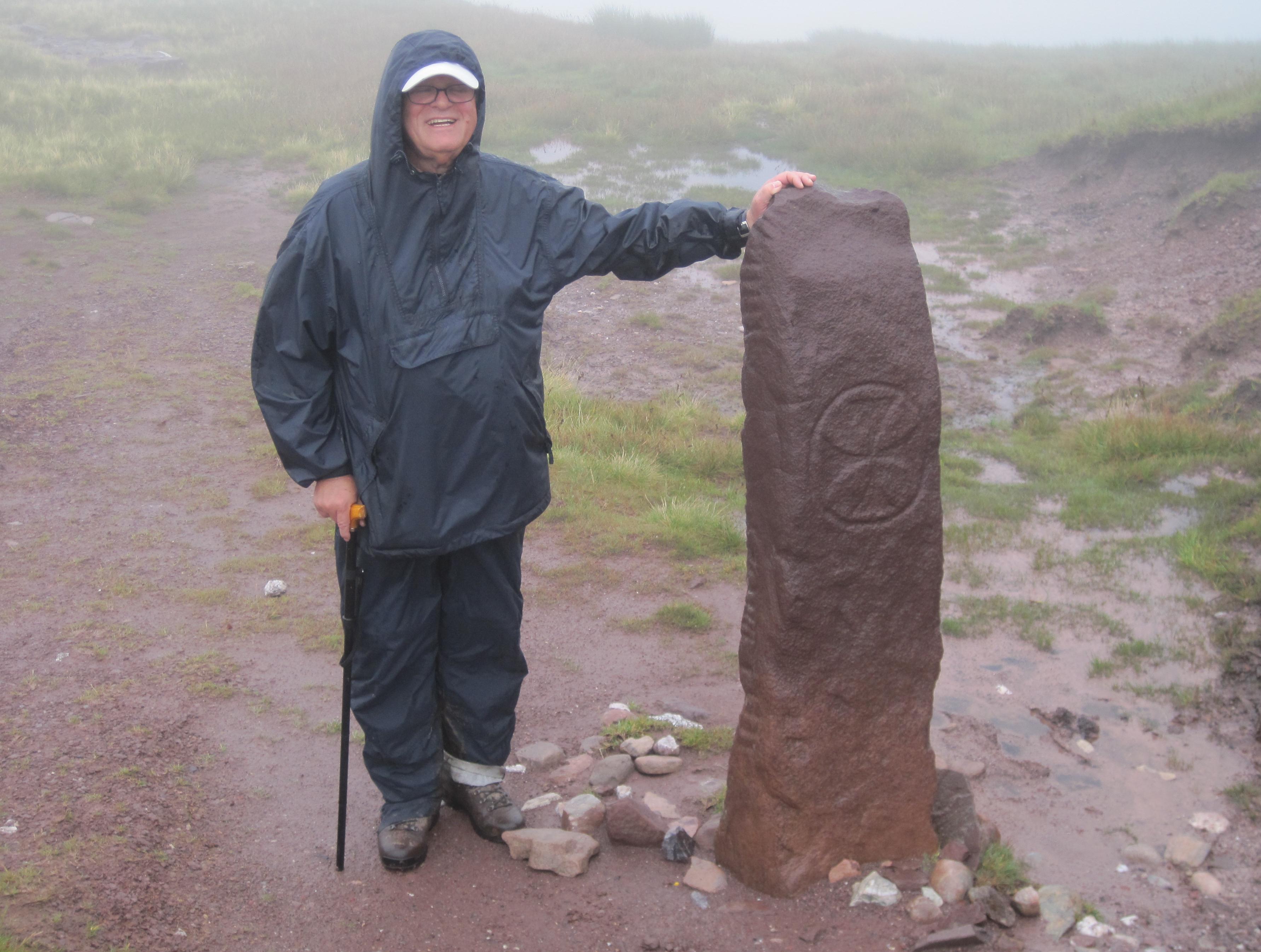
At the Ogham Stone. I used a version of this
photograph as an illustration in A Walker’s Alphabet.
There were dramatic views behind us of the whole indented coastline and we both paused frequently to take pictures of this scene. Once a shower overtook us (Gavan was as good at predicting such an eventuality – as Harold had been) and we were soon in full rain gear. It took a long time for us to catch a glimpse of the pass we were heading for; Brandon Mountain on our right was, of course, cloaked in cloud – but so also was the peak on our left, Masatiompan (which sounds as much like a Native American as an Irish place name). It was 1:10 when we at last arrived at the desired col. Here there was an ancient monument, the Ogham stone – which evidently contains the secrets of an ancient alphabet. Each of us posed for a celebratory photo and then we turned our attention to the northerly descent.
The next mile or so is a notorious one, for it must be undertaken at sharply descending angles over a route (I won’t call it a path) alternately muddy and rocky: a little like the route to Camp – except steeply downhill. The weather improved rapidly at least and we were soon bathed in warm sunshine but the treacherous nature of the route lead me into several falls and near-misses, staggering, stuttering all the way. Once, while I was innocently just standing there, the mud beneath my feet gave way and I suddenly found myself on my backside. A couple of walkers down below us seemed to be always in view: this was a bad sign for it meant they too were making very slow progress.
On some convenient rocks we paused for a brief lunch and some water, then we were off again. I was happy to have the cane with me because it did provide some leverage as I leapt from rock to rock but in the marshier parts it was a nuisance, with the bottom third sticking in the mud while the upper two thirds (all attached with strong elastic) continued forward with me. Either there would be an almighty crack, as the bottom snapped back into place or I would have to stop and pull the bottom out of the mire myself.
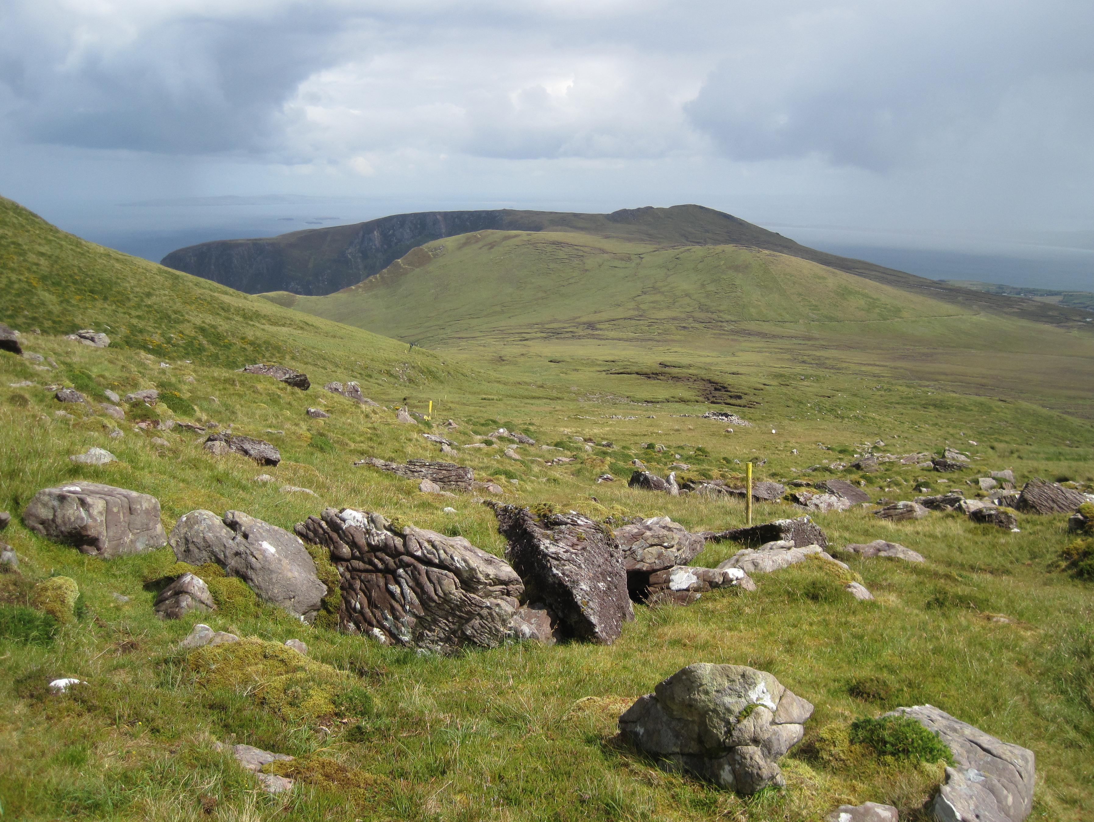
The difficult descent from the Brandon pass
Ahead of us I could see the moorland track that promised the start of some decent walking surfaces, but it seemed to take forever to reach it and when we did we had to go uphill again. It was 3:10 and it had taken us almost two hours to descend only a little more than a mile.
When I had added mileage markers to the map for today’s march I had not known exactly where we would start so I had put them in reverse order. Thus we knew, as we reached solid footing at last, that we had exactly five miles to go – the Dingle Way undertakes a northern excursion to Brandon village but I had plotted a course that would take us directly to the village of Cloghane via the quickest roads possible.
We had soon reached the crest of our track and could at last begin a descent back to the coast, though this time we were heading for Brandon Bay, on the peninsula’s northern shore. Gavan was again carrying my camera as I had abandoned my rain jacket in the hot sun and I had to borrow it from him on a number of occasions. I was often out in front on this stage, Gavan hanging back because he could at last get a signal for his mobile phone here, and it was time to get caught up with affairs in the office back in Hartford and with his family (Brother Jim never lost an opportunity of telling him how well the Yankees were doing at the expense of the Red Sox).
As we entered more agricultural surroundings we also encountered more dogs, some of them muzzled. Then it was truly back to civilization as we crossed a river and reached the main north-south road, the one that goes all the way out to Brandon Point. Our direction was a southerly one and fortunately there was not too much traffic. We ignored a final DW attempt to get us off road and, feet aching, we at last reached the village of Cloghane. For the last five miles we had been walking at a pace of 31 minutes a mile, close to twice as fast as the first five miles. It was 5:45 and, yes, we had covered ten miles – at least on the map…who knows how many we had actually covered?
I paused to take a picture of O’Connor’s Bar and Guesthouse and was saluted with the raised steins of the Dutch/Danish foursome. We found our bags and moved them into a room, again on the ground floor, then repaired to the bar for some liquid refreshment. Gavan had convinced himself that an Irish brand of crisps, Tatos, was superior to anything English, and we had plenty of these and some nuts as well. Our host, Michael (well that’s not the Irish spelling) introduced himself and we amused ourselves with all the humorous bar signs. Gavan wanted to know if they still taught school children that the shape of Ireland resembles a teddy bear driving a car but our young barman, Sean, had never heard of this. I drank two pints of lager in rapid succession.
I drank two pints of lager at the bar and a third at dinner a few minutes later – surely a record intake for me. The crowded dining room contained a party celebrating a young man’s birthday and a number of the other walkers were here as well. I had the scampi this time. Out behind the bar was a field in which campers were allowed to set up their tents. Seabirds kept up a racket throughout the evening. I know because I had to take a sleeping pill at midnight.
To continue with the next stage our walk you need:
Day 7: Cloghane to Castlegregory