
August 16, 1994: Crosthwaite to Cartmel
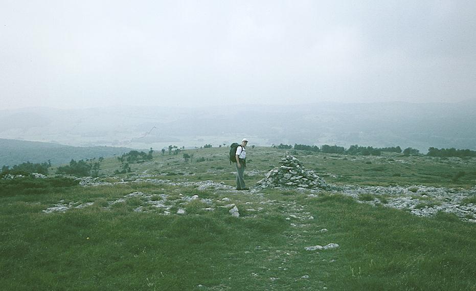
Gavan on Lord’s Seat
We went down to breakfast at 8:30 – on the third day of our walk. There were no other guests about and it took a while to rouse the attentions of the staff. Gavan had the full breakfast and I dined on scrambled eggs and toast. Then the chef, who was preparing to take over management of the pub with the barman, brought us some sandwiches and we went back upstairs to pack. There was still some evidence of the sun –trying to peek through a cloudy sky.
At 9:40 we were ready to descend from the churchyard to a little lane that began at the graveyard – which our spooked hosts were convinced bore the shape of a coffin. I noticed that a young cat was following us. While we struggled through the overgrown brambles and nettles of the lane, the cat raced along on the wall opposite us, or along the field edge on the other side. After ten minutes of struggle we reached a little lane, but the cat seemed to want to follow us here too. I tried to chase her away, thinking very much of our adventures with Skip on the North Downs Way, but at a cottage-turned-management-center she found something else of interest and we were able to cross a bridge over the young River Gilpin –and take a second lane up to the A5074. After a short turn to the left we encountered the tarmaced farm road to The High farm and began to edge up it its steep shoulders.
Just before the road entered the farmyard I found Gavan – waiting for me at a gate. This admitted us to a field where there was more steep climbing as we ascended the nose of hidden Whitbarrow Scar. A short scramble up to a gap stile put us on a high track that actually descended for a bit before leveling off for a long stretch above the valley on our right. We made good progress on this surface, Gavan often quite a distance ahead of me – but after coming near Fell Edge farm the track petered out, and we followed a steep forest path up to open territory before reaching a stone fence. We had a nice rest after we had climbed over this – for we had reached the fell top and the worst of our exertions were over for a while. It was still cloudy and bright and the open vistas of limestone and heather proved to be very exciting.
We headed for some boulders and then followed a ditch toward another rock wall. After climbing it we were able to see the cairn atop Lord’s Seat – at 706 feet one of our chief summits for the day. We walked along the edge of a forest for most of this fell-top stroll and there was even a period of light mist – but this was mostly over by the time we had given up the protection of the forest wall to head more directly for the cairn. We had a brief rest here too and took some photos. The sun was about to make a brief appearance and the fell top scene was enchanting.
Next we headed west, stopping just before the edge dropped away hundreds of feet below us, and turned south on a good path that gradually descended through the Park Wood. This was a very rough section on the toes, for the angle of descent was quite steep on some occasions and I found myself clinging to trees and hopping from heights. A family was struggling up the other way but I almost envied them. At last we reached the valley bottom, continuing south for a bit until, near a football field, we turned away from the cliff edge and headed toward Witherslack Hall.
We passed a farm and reached a road, where we turned right for a few yards; then escaped this for a lane. Gavan wanted to rest here so we sat down on a wall top. Our new track curved south and we passed through woods and open fields as the skies got greyer again. Gradients were not too steep on this section and we seemed to be making decent time, already having covered some six miles by 12:30. Eventually we zig-zagged down through the woods to a little hamlet that contained Witherslack Church. Here we spent some time in the churchyard while I took the obligatory photograph.
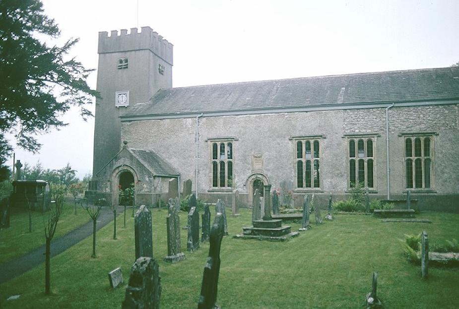
Witherslack church
It was a bit hard following the guidebook instructions for the next few minutes; for instance I never say a sign to Halecat nor anything resembling a natural rock garden, but we did reach the designated lane. There were a lot of instructions about gates and stiles as we crossed from woodland to open field and it was obvious that Gates stood a better chance of victory today. The route emerged onto a farm lane at Slate Hill, where we turned south for a period of road walking. At a t-junction we reached another lane – but we were passed by only one vehicle as this road also curved south to bring us to Nichols Wood. Here we decided to eat our lunch.
I ate the cheese sandwich while Gavan scoffed the ham and the prawn. Just as we were about to start off again a light rain began to fall, so we paused to put on rain gear. We only needed it for about an hour, but it was an uncomfortable hour – not so much because of the moisture but because of several route-finding puzzles. After passing Nichols Wood Farm we left the woodland behind us and used a farm bridge over the River Winster. But the route south did not seem to comply in all respects with the text of the guidebook, which mentioned several absent gates, and as we neared the whizzing A590 it was not obvious on the ground which route we were to take to head to the west. The area had been heavily bulldozed but there were some paths and some footpath arrows and so we struggled westward until what we encountered once again began to resemble to text. Between the quarrying and the cow muck and the electricity pylons it was not a very gratifying countryside.
A farm track put us out onto a lane, where we turned right to climb a stile opposite Lindale Crag. The guidebook asks us to find a sketchy path through bramble and bracken on the open fell but after several attempts to find such a route, thrashing our way through the underbrush and searching for any sign of what might have been a trod, we retreated to the style in defeat. I got out the OS map at this point but I decided there was no point in trying again. Lindale was very easy to reach if we just walked south on our lane, so we re-climbed the stile and turned right, soon walking beneath the highway overpass and reaching the outskirts of the village at a corner on which one cottager had planted his flowers in twin toilet bowls.
The trick was linking up with the Furness Way on the other side of the village. Before making such an attempt we paused at the Lindale Stores and Post Office and I was sent in to get us something to drink. It had just gone 4:00 and there was no point in hoping that the pubs would be open. In a refrigerator cabinet I found some cans of icy beer, so I bought a John Smith’s bitter for me and a Guinness for Gavan. Gavan wanted a glass but I told him he would have to make do with the can. He did a good job of using the OS map and the guidebook to get us out of the village; none of the landmarks in either seemed to make sense to me – but then I had chugged my beer rather rapidly.
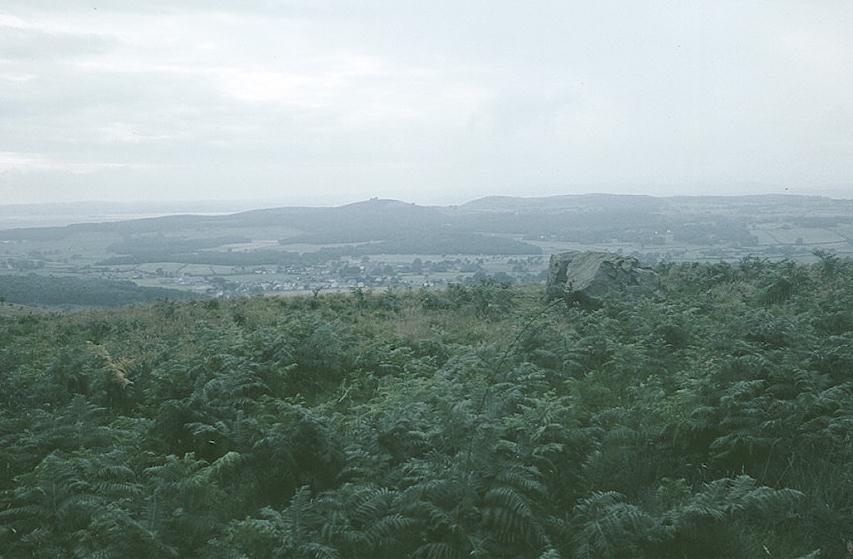
View of Cartmel
We had a very steep climb up to Hampsfield farm, with good retrospective views of the village. Once again we followed forest fences on open fell and we used a zig-zag route to climb up to Hampsfell’s limestone plateau. We crossed several stone walls and found The Hospice, a square hut with a viewing platform atop. I had a rest below while Gavan scrambled up; then it was time to head south again along a lovely ridge. Gavan began the turn to the west a bit too early and we had some rough moorland to cross before reaching a track that descended steeply and rapidly toward Cartmel, a quite sizable village that lay beckoning beneath our height. At the end of the day, as we edged our way around Pit Farm, Stiles’ last attempt to catch up with Gates failed, and Gates emerged a 25-20 winner – as we stomped the mud off our boots on one of Cartmel’s outlying lanes.
On our way to the market square we paused at the Priory church, a very imposing structure, though already closed for the day. The Market Square was quite charming and, at 6:00 we located Market Cross Cottage at one end and were welcomed by Mr. Burgess. He relieved us of our boots after a tiring thirteen miles and we went upstairs to a nice room that had its own shower and toilet. Here we got cleaned up and at 7:00 we descended for our evening meal – the only one on the entire trip cooked by our hosts. We had beef in red wine sauce, nice vegetables and a gooey dessert. Mr. Burgess was a cornet player in a local band and his trophies lined the dining room.
It was dark when Gavan and I, armed with a front door key, went outside to visit a local pub. We chose the King’s Arms but, because everyone was still eating here, we waited to light up our cigars. I called Dorothy and Gavan called his folks in Connecticut. There was a brief downpour outside while we supped our ale. Gavan had us move once because he complained of the body odor of a tourist at the next table. We returned to Market Cross Cottage by 10:00 and were soon in bed after a very satisfactory day.
To continue with the next stage our walk you need: