
June 2, 2001: Erith to Old Bexley
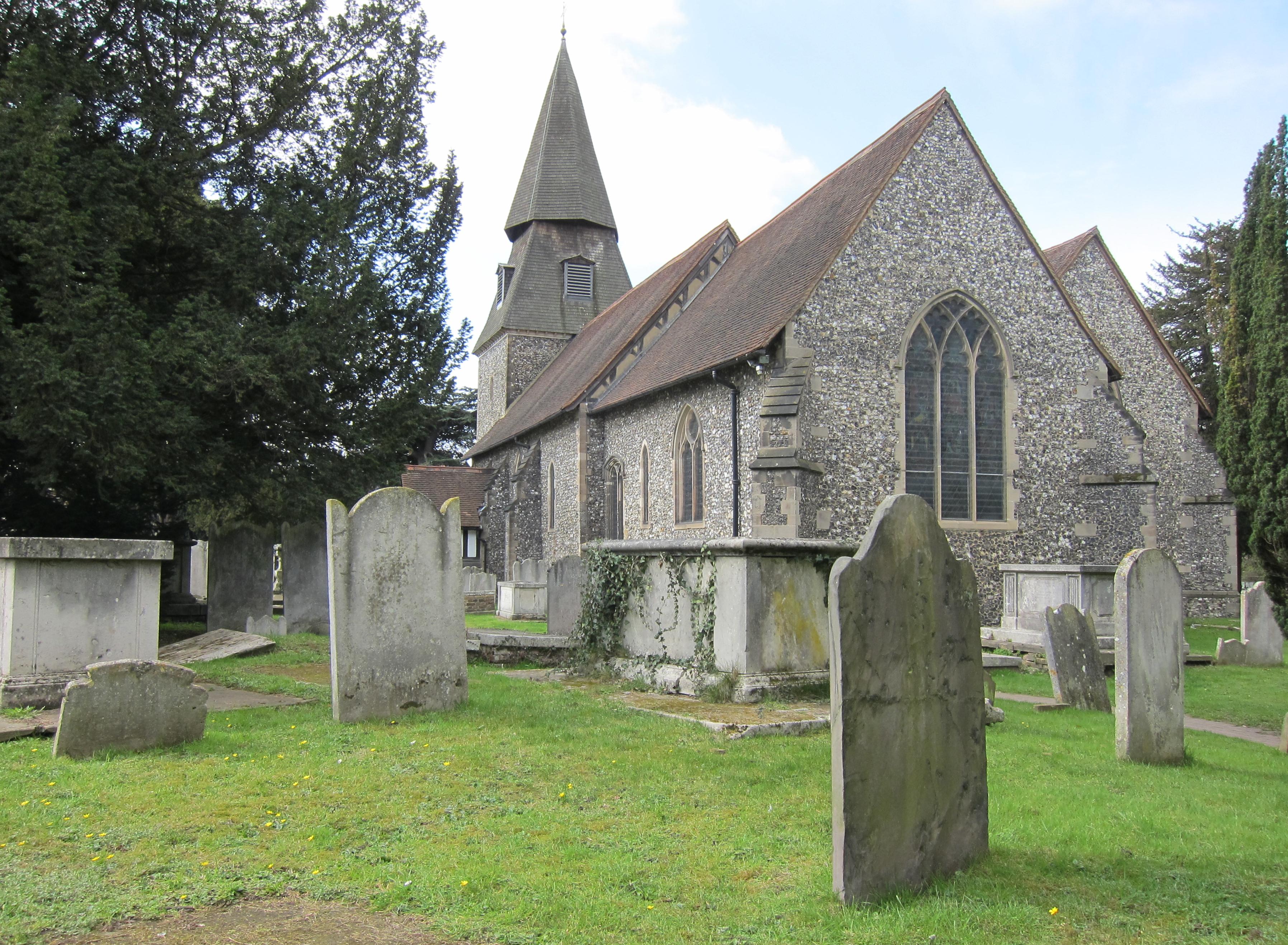
St. Mary’s Church in Bexley ¬– at the end of our first day on the LOOP
Almost three quarters of a year had passed without any opportunity to undertake our usual footpath adventures. Neither ill health nor the pressures of work were to blame this time, but a (hopefully) rare event in the history of the British countryside – a major outbreak of foot and mouth disease, one that effectively closed almost all footpaths from February on. Naturally we had wanted to complete the last stage of the Saxon Shore Way and to do some planning with certainty about a summer walk as well, but, even though some regions had reopened their paths, it was almost impossible to gain reliable information about open routes. (The relevant page of the Country Agency’s website continued to crash whenever I summoned it on my screen.) Except for some of the great parks, however, London itself had remained immune from any closures and so, when a new guidebook appeared for the London Outer Orbital Path, I purchased same, and we decided to have a go.
The route, designed by the London Walking Forum, was another one of those projects, like the Thames Path, that David Sharp had helped bring to life, and he had written the guidebook in the Recreational Path series. There are fifteen stages, roughly ten miles in length, conveniently positioned to link up with public transport and all within Greater London itself (Red Ken had written the introduction to the volume in question). I decided we might as well start at the beginning, Erith, and research on Railtrack’s website had mandated an 8:30 rendezvous at Cannon Street – of all places.
I strapped on the boots on a gray Saturday morning and left the house at 7:30. Both of my feet had questionable tender portions, but in the event they seem to survive pretty well. I inquired about a 6-zone travel card at the Maida Vale tube stop and was advised I could use it on train, bus as well – so for £4.90 I seemed to be set for the day. I changed at Embankment where I bought a Snickers bar and some Cherry Tunes for my persistent cough. Four stops later the Circle Line train reached Cannon Street. It reached it, but it chose not to stop here (this being a weekend) and I had to get off at Monument. (Can you imagine Paris closing a Metro stop that provided the closest interface with a mainline station – just because it was the weekend?) I was early and I knew it wouldn’t be a long walk back to Cannon Street itself, but – just to be sure I was heading west – I pulled out my compass when I got up to the street. On the trail itself I had no use for this object.
I bought a banana at a cafe and waited around for the Lees at the station. There was an 8:29 for Erith but we missed it because Tosh was in the loo. She then disappeared to get us coffees, though she ended up pouring out half the contents of these giant concoctions on the tracks while we waited for the 8:41. The journey was about 35 minutes long and I used the time to fill the Lees in on school gossip. We kept looking for signs of rain (which had been predicted), but it was still dry when we reached our station. Tosh borrowed a key so she could use the loo here too.
It was 9:20 when we began to make our way down to the riverside gardens, opposite Erith’s swimming pools, but we hadn’t gone three hundred yards when the first drizzle began, and we paused to put on our rain jackets. There was a fine view of the Thames from a convenient viewpoint, with Cold Harbour, the end of the LOOP, just across the river. We then headed east – but building works drove us away from the riverside before we were quite ready, and we passed through a supermarket parking lot as I looked for a way up to Manor Road. Here we turned east again, the sun coming out and the jackets off. Our first mile was probably the least edifying start to any long distance path we have ever used – scrap yards, thundering lorries, and factories all very prominent. Straight ahead you could see traffic inching over the span of the Queen Elizabeth II Bridge.
At last we were able to escape the worst of this, turning off on a track to the Erith Yacht Club and soon reaching a raised causeway that crossed the Crayford Marshes – heading for the beacons at Crayford Ness. All of a sudden we were overwhelmed with what we had been missing – some genuine green countryside and wonderful distant riverside vistas. There was no one about, expect for a chap who was leading one of the local ponies. We passed several of these animals, tethered out here to munch the grass at trackside. At Crayford Ness we circled a lorry graveyard and began to walk south along the Darent. Overhead Harold spotted two vintage aircraft making their way, we supposed, toward the Biggin Hill air show. That day one of them crashed, killing two; the next day there was a third fatality in a second crash.
Walking, indeed, was easy, and we made good progress along the banks first of the Darent and then, as we turned southwest, along the banks of the Cray. There were no signs for the London Outer Orbital Path here (not all sections had been waymarked at this point in time) but the Cray Riverwalk was well signed and our route corresponded with this for most of the rest of the day. Once we sat down above a reed bed and had our elevenses – I ate my candy bar.
Then we continued toward Barnes Cray (passing a piece of heavy equipment with the logo “Putzmeister”) – with tractors at work in the fields until, nearing the rail line, we rejoined juggernaut lorry heaven and made our way up to the A2026. It was about 11:40 and the back doors of the Jolly Farmers were open – so we decided to make this our lunch stop.
There were two chaps at the bar and two dogs as well, one lying on the floor and a second pacing nervously about. The chaps wanted to see the cricket so the bartender turned on a projector that broadcast the TV image onto a screen; but the room was too bright to see much of what was happening. The cook hadn’t appeared and so we just had half lagers while getting a lot of advice from everyone on where we might expect to find food on the route ahead. We left at about 12:15, crossed the highway and the river on a road bridge and walked along the southern bank of the Cray on a track.
At the end we reached a road, turned right and continued on Barnes Cray Road, walking behind houses and looking down on the smoothly flowing river tugging at the eelgrass. “All that’s missing from this scene is Ophelia’s body,” I said. It rained very briefly on this stretch and we pulled on our rain jackets again. Our track ended at some steps that brought us into the heart of Crayford, which we crossed via a tiny flowery park, pausing at a traffic light and continuing west along the busy London Road. We then forked left on Bourne Road, passing the Silk Centre.
This was not particularly pleasant walking and about the only matters of interest were two decorative columns from the old Crayford cinema, now serving as light standards in the forecourt of a large car lot. Our turnoff onto a huge greensward was not far away and we headed over the pathless grass back down to the Cray, which we followed all the way to the hedges surrounding Hall Place.
The publican at the Jolly Farmers had recommended the food at the Jacobean Barn pub (two pubs beginning with J on the same day), part of an interesting set of structures including a stately home built in two uncomplimentary styles. The maitre d’ would really have liked to send us into the restaurant half of this establishment but we opted for a table in the bar. Tosh ordered a BLT (insisting, however, that she wanted only two decks) while Harold and I had the haddock and chips. It was very warm in the place (and everyone was smoking) and I took off my sweatshirt. We drank some more beer but I didn’t finish my pint. We were in no rush since the Lees were planning on staying in London to attend Don Giovanni at the ENO (they actually had their going-to-opera clothes in their packs) and we could see they would have plenty of time to kill.
Before resuming our walk at about 2:30 we had a stroll around Hall Place’s formal gardens, and I must say these were lovely. There was some amusing topiary, some geometric and some in need of a trim – so much so that the White Lion of Mortimer, according to Sharp, had become an overgrown teddy bear. Cricketers were heading back to the greensward as we resumed our walk, returning to the Cray and crossing it on a bridge from which an angler was actually pulling in a fish (though very small.) We had the hedge on our right and we turned west with it to approach a rail line.
Here we could see the reason why there would be no afternoon trains at Bexley station – a large crew of workers replacing track beneath a bridge over the A2. We climbed up to this dual carriageway on steps and walked over the bridge, then took a metaled path down the slope in order to walk under the span on the opposite side of the track. In this way we passed beneath the roaring highway, accompanying it on a parallel path eastward until we reached a turnoff along the margins of Churchfield Wood. This was a delightful stretch, with heavy foliage on the left, Cray meadows on the right and the spire of Bexley church ahead. I let the Lees get well ahead of me as I strolled in the last of the afternoon’s fresh air. There had been no hint of rain for miles.
The Lees were waiting for me at a crossing track, one that took us up to the church, with its odd shingled tower. We were in Old Bexley now and our first stop was a Tardis-like loo. Traffic made it difficult to cross the street to a stretch of town containing a Greek, an Indian and an Italian restaurant. When we had walked up the station approach road, shortly after 4:00, there were signs informing us when to expect a replacement bus service and some cabbies told us where to wait on the main road.
We found our stop, its sign buried in the branches of an overhanging tree, but we had almost 25 minutes to wait and Tosh went over to a newsagent and bought a Times, the one with the news about the slaughter of the Nepalese royal family. She gave the cellophaned TV section to a puzzled woman who was also waiting for the bus, but the woman gave it right back to me and I think it was because I was clutching this, when the bus arrived shortly after 4:30, that I boarded this vehicle with a portion of Tosh’s newspaper rather than my map case and my new copy of Sharp – which, I soon discovered, I had left behind forever in Old Bexley! The purchase of this paper had the additional effect of taking the savor of opera-going from the evening plans of the Lees – since it contained two dire reviews of the production in question.
Our bus stopped at four additional stations and reached Dartford at 5:00. I was now outside zone 6 but a guard let me through when I explained that I was actually a Bexley passenger – which is within the zone. We waited less then ten minutes for a Charing Cross train – another slow-moving craft. It was 5:40 and instead of going to the tube I decided to walk up to Stanfords and repair my recent loss in the guidebook department. The Lees walked part of the way with me, intending to have a coffee and eat at Joe Allen’s before their opera but, Tosh told me, they later exchanged their tickets and went home.
After buying another copy of the guidebook I also went into Ellis Brigham’s for a new map case and, almost 20 quid lighter, made my way home at about 6:30. Well, in spite of all the difficulties that marred the end of this expedition, I was certainly glad to have gotten back on the trail again.
To continue with the next stage of our walk you need: