
July 4, 2001: Old Bexley to Petts Wood
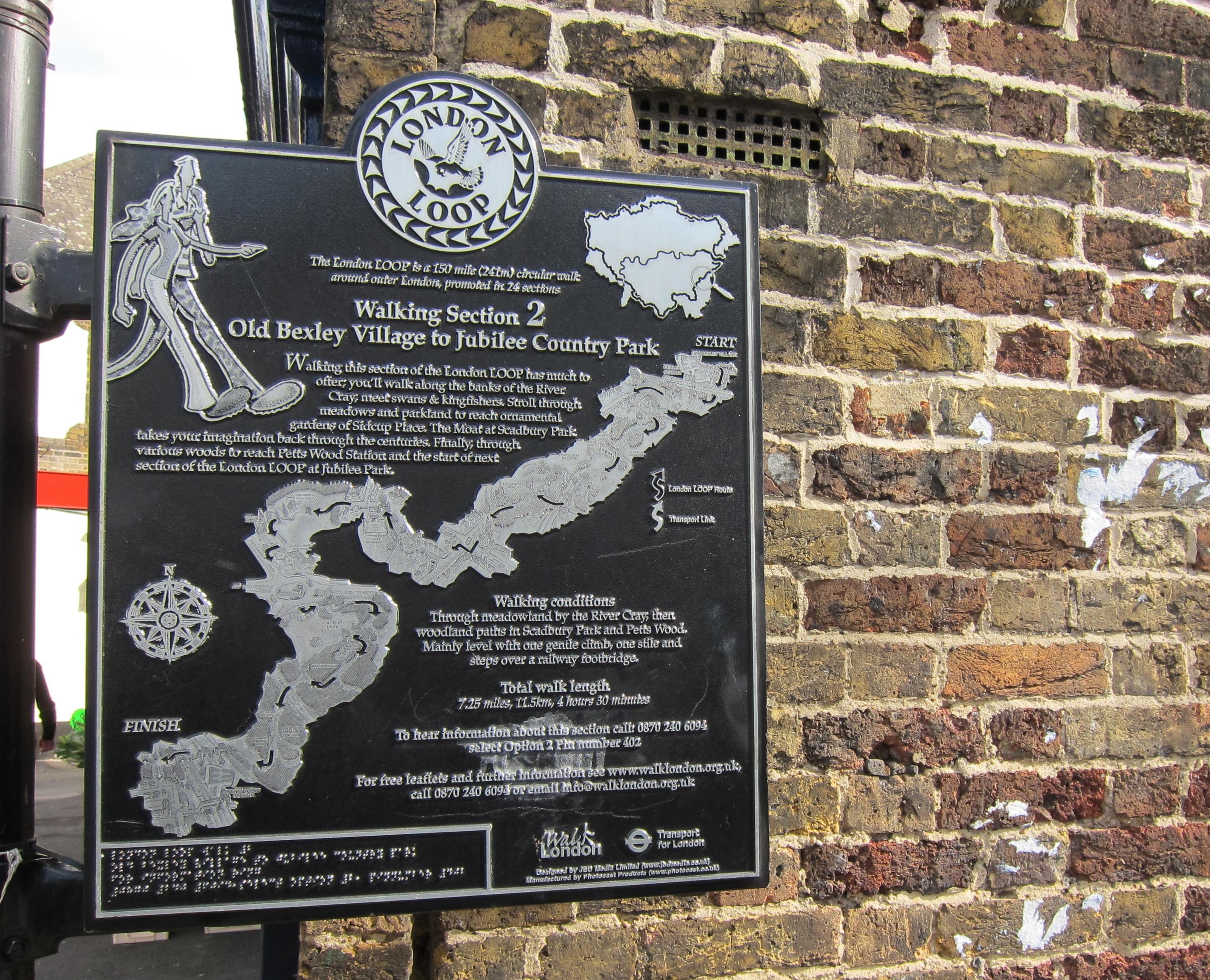
Near Bexley station we see an outline of the second stage of the walk.
Only six days after a foot and mouth disappointment on the Saxon Shore Way, the Lees and I returned to Charing Cross to complete the second stage of the new London Outer Orbital Path. We knew that a walk within the confines of Greater London would be less likely to be affected by restrictions, real or imagined, and that we could get in a manageable eight miles on what was destined to be a very hot day.
Tosh called in the morning to ask for an even later departure time than 10:08 – so that she and Harold could use their Freedom passes on the underground after 9:30. In the event we agreed to take the 10:38 and I left the house with an hour to spare, pausing once to buy some sunscreen and reaching the train station in plenty of time to buy a candy bar and some water. Once again I would do all of my travelling on a six-zone travel card.
We reached Bexley station at about 11:20 and paused outside so that I could adjust my new guidebook, my new map case, and my new prescription sunglasses. Then we used the access road to the high street, turned right for half a block and entered a back alley that took us under the railway line. Already we were back on the LOOP.
It was quite warm in the sun, particularly when there was no air circulation, but in open stretches, such as our march toward the grounds of the Bexley Cricket Club, we noticed a lovely breeze at our backs. We passed a terrace of houses and approached a track over a landfill. I called Harold back at this point because it was here that I first noticed an authentic LOOP waymark – there had been none on the first day’s march.
At the top of the landfill we reached a heath, remarkably unspoiled for a site so close to the metropolis, and continued forward until it was time to descend to a kissing gate (no longer in use) and a path out to a suburban corner near a Thames Water pumping station. We had to pass only one house before a tarmac path lead us down, once again, to our old friend, the River Cray.
We continued upstream on the south bank, again marveling at the pristine, clear waters flowing rapidly over the gravel of the riverbed. Tall trees (some of which, evidently, play host to a colony of fugitive parakeets) provided us with plenty of shelter from the warm sun. No one was about – but this changed as we approached the lovely Five Arch Bridge, where a weir created a miniature cascade on one side and a duck-filled lake on the other. Here people were walking their dogs and many of the latter (including all the Labs) had been in for a swim. One woman, accompanying a Spaniel named Suzy, paused to tell me that a factory upstream had accidentally discharged some detergent into the river a few weeks back – and that those downstream from the weir had awakened to a fifteen foot wall of foam.
We continued forward along the waterside, gradually losing contact with the river as we neared the Schweppes Factory (so this is the source of all that Schweppervescence) and using a footbridge over the river to approach the confines of All Saints Church in Foots Cray. The lady with the Spaniel was here too and showed us how to get to the churchyard without using a path overgrown with nettles (Tosh was once again in skirts on this expedition, Harold in shorts).
We then used Rectory Lane to continue to the west, passing a schoolyard in which the youngsters were in recess. Tosh wanted to know if their school uniform included neckties and one little boy obliged by pulling his out and giving it a tug– it was attached with elastic. At the signal at the Foots Cray crossroads we spotted a pub, The Beer Engine, and decided to pause for some liquid. This was a nice old pub, but I’m glad we hadn’t planned on eating here – since it was not serving any food. We just drank Cokes today – I had a pint of the frosty nectar.
We didn’t linger, since lunch beckoned some distance ahead, and soon we were back in the sun to follow Cray Road for a few blocks before dodging the traffic and turning right up Suffolk Road. At its end we followed a parkside path for a few twists and turns (the last was followed by Tosh to the left when we needed, in fact, to go right through some bollards). There was a ball in the track that Tosh returned to the playing fields as we drew level with the stands of the local football team, The Cray Wanderers. (I wanted to start another team, The FootsCraypers).
We were now approaching a genuine hill and I challenged Harold to see if he could find something that reminded him of his Northern California past here. I was referring to a tribe of lofty redwoods surrounding Sidcup Place, an impressive structure that had once housed council offices and now served as an inn. Harold walked right by the redwoods as Tosh paused to study a LOOP map – there were even LOOP mileage signs at the top, which we reached at about 1:20.
Once again, as in the Jacobean Barn, they tired to hustle us into the restaurant section and we opted for closer proximity to the bar. The Lees changed our seating three times in the process (and I temporarily lost contact with the map case again) before I insisted on a table next to a music stand and a cello, a spot that seemed to be getting some breeze. I was pretty knackered from the less than four miles we had covered in temperatures approaching 30 degrees – 86 Fahrenheit – and a bit bleary-eyed from wearing my new prescription glasses – so I attempted only a chicken and bacon salad for lunch. Harold had salmon and Tosh paté, but she did order a spotted dick and custard for afters and I helped her with this. As in the Bridge Inn the previous week, the room contained only geriatrics (making us feel like teenagers) including one garrulous old lady at the next table who couldn’t stop talking. Our waitress was chatty too and we had to hear about her son’s transfer to a football school in Phoenix, Arizona.
While the Lees were at the loo I reached beneath the table to detach, for the first time, the legs of my new Hawkshead trousers, the ones which can magically assume the role of shorts once all the zippers have come undone. Then we returned to the mileage post and turned south, passing along the ornamental gardens and turning right to reach the main road, where we walked on grass as far as St. Mary’s Hospital.
A complex bit or routefinding at the junction of the A 20 and the A22 now ensued, just at the moment when LOOP signs ceased to exist. We followed Sharp’s instructions as best we could, dropping down a cycle and pedestrian path on tarmac and turning right to pass under one of these roads. Then some steps brought us up to street level again and we used a pedestrian bridge over the motorway. Then we descended again for what Sharp calls “a repeat performance” (but of what?) before rejoining the street level once again. I was looking, however, for a stile on our right and none appeared where I wanted it to be, so I asked the Lees to halt while I fished out my compass and had a squint at the OS map. I was pretty certain I knew where we were, but it wasn’t where we were supposed to be at all. So I called for a retreat and we descended once again to the pedestrian underpass and I chose a different exit from this spaghetti junction – and when we got to the top this time we were able to head south, rather than west, and here I quickly spotted a stile into Scadbury Park.
LOOP signs were in evidence here, although already vandalized, and we continued forward in a southeasterly direction on rather overgrown paths, reaching Little Wood, where we switched to a more southerly line on an improving track. Woodland now predominated and it was a relief to be in the rather humid shade, but there was cloud in the sky by now anyway. Often I took off my Gap hat in order to let my head breathe. I was looking for a little pond – which Sharp tells us serves as a spot where local children come to study crawly creatures and, sure enough, we encountered these children, with their specimen jars and their screeching games and their mock horror long before we drew level with the pond. They were on a school outing and one of them had just bagged a newt.
When our track ended we were asked to turn to the left and to look for a right-hand turn shortly after encountering a chain link fence. We reached this spot but there was no sign at the first turnoff and I wandered down the hill a little bit to see if the continuation might be here. Convinced we were right the first time we turned onto this southwesterly path, our instinct rewarded when we drew level with the moated site of Scadbury Manor House. Our route took us through Park Wood, with the Lees getting well ahead of me here as I dragged along. Tosh paused once to proudly identify a stand of rosebay willowherb and again for a loo stop.
Then we turned south, then north, then west to cross the A208 into Petts Wood. Things were pretty straightforward here and we continued under the shade, descending gradually to the first of many rail lines where we turned right, keeping the track on our left until we at last emerged from woodland and used a pedestrian bridge to cross to the other side. We were in the outskirts of suburbia here but we had to use a second bridge to cross another line a minute or so later. As we entered Jubilee Country Park a local lady, walking her dogs, advised us on how to get into Petts Wood village – it was rather well marked anyway and we passed through a car park and turned left on Tent Peg Lane. The latter curved around and headed unerringly for its continuation, the high street of Petts Wood itself. It seemed strange to walk on the wide pavements past the restaurants and shops of a thriving village center – back in the sun again – but after a few blocks we reached the station road and turned left to mount a third pedestrian bridge.
Tosh asked a lady on top which was the best platform for London and the response was, “If you want a Charing Cross train, there it is.” A train had just pulled in at platform three so we ran down the stairs and threw ourselves aboard the nearest carriage and we were off. What great timing – it was 4:20. The ride was not a long one (no time for a nap) and at 5:00 or so I said goodbye to the Lees (on their way to the opera again) and headed home on the tube. At 5:45 I reached home (where ASL’s David Buck was fiddling with our computers and the Vincents were half an hour away from an overnight stay).
To continue with the next stage of our walk you need: