
August 19, 1974: Gargrave to Malham
Looking west from Bell Busk Lane
On the afternoon of August 17, 1974, I boarded the Leeds train at Glasgow Central Station and began a journey which, in many ways, changed my life. Of such a possibility I was completely ignorant at the time. My mission was purely recreational – I had just clambered off a transatlantic jet in order to spend several days walking on Britain’s first official long-distance footpath, the Pennine Way. What was not clear to me was that such an endeavor would play so important a role in my imagination, my system of values, even my attitudes toward culture and identity. And even more remote at the time was the likelihood that one day I would want to write about my experience as a walker.
An elderly couple was seated on the opposite side of my compartment. They ate sandwiches and creampuffs and read pamphlets on animal magnetism. They offered me boiled sweets while I studied the Ordnance Survey maps. After Carlisle, when late afternoon sun had replaced grey Scottish showers, I was actually able to follow the route of the train on my maps as we chugged along the western escarpment of the Pennines themselves. Although this was my fifth visit to England I had never travelled through this region before, and I was eager to catch sight of summits I hoped to surmount in only a few days.
I would spend a week or so on the route’s midcourse, beginning in Gargrave, North Yorkshire, a village some seventy miles from the Way’s origins in Edale, Derbyshire. Indeed our train soon rattled through Gargrave without stopping. I spent my first two nights in England, therefore, in the much larger nearby mill town of Skipton.
The sun was setting as I left my train. I had not been certain of my arrival time and I had not arranged for a place to stay. Suffering from the fatigue of my plane flight from Detroit and this day’s long train journey I was not looking forward to a long search for accommodation. It was also soon obvious that Skipton railway station was located at some distance from the town center. I asked the ticket taker what he recommended and he advised me to try to the Midland Hotel, across the street. I felt most awkward edging my way into the crowded Saturday night pub of the hotel, knapsack on my back, but I was soon made welcome by Mr. Ledbetter, the landlord, who had a small room available on the top floor. I ate the last of the airplane’s cocktail peanuts, did a puzzle, and tried to accustom myself to lying on a set of those sleazy pink nylon sheets favored by provincial landladies. After midnight, when the last door slammed on the last pub-goer’s car, I finally fell asleep. I would spend one more day of recuperation in Skipton before beginning my adventure on Monday.
When the morning of my first day on a British footpath dawned at last, I was filled with the most intense feelings of anticipation. Following an ancient Southern California ritual, I applied a circle of adhesive plaster to each toe and larger strips to those portions of my feet most likely to blister. On went the heavy socks and the hiking boots. Nervously I stamped around my little hotel room for several minutes, but I was still too early for breakfast in the dining room below. This gave me time to readjust the contents of my knapsack one more compulsive time.
After a solitary but satisfying morning meal I strolled into Skipton again and bought some stamps, some crisps, and – as it was going to be a sunny day – a green canvas hat. This object survived as a family possession for many years. We called it my Filipino gardener’s hat, even though it was made in Hong Kong. Back at the Midland Hotel I vacated my room, crawling around on the floor to see if any precious needed object might have rolled beneath the bed. None had. I paid my bill and approached the railway station. I was still too early. Impatiently I marched down the line and took a picture of the Sylko Thread Factory. When it was time for the train to arrive from Leeds, it did not. My quest would begin fifteen minutes late.
I am not a superstitious person; if I had been, then the first few minutes of my first official day on a British footpath might have been my last, for the omens were not propitious. When the train arrived I rushed forward to enter by the first available door. Just as I was about to swing into the carriage I noticed that it was full of first class compartments only. Since I had purchased a second-class ticket I feared I was about to commit a serious breach of railway etiquette. In consequence, I dropped abruptly back onto the platform and, as it turned out, directly into the path of a porter and his goods trolley. A wheel of this hurtling juggernaut rolled over my right foot! In shock I stumbled aboard a crammed second-class carriage, where I had the greatest difficulty in locating a place for my pack. The only vacant seat was opposite an unfortunate Downs Syndrome child. She played with a tube of Smarties while I attempted to see if it were still possible to wiggle my toes.
The heavy hiking boot must have offered considerable protection, for in a minute or two the foot stopped pulsing. There wasn’t going to be much time for recuperation, for the distance between Skipton and Gargrave is only seven rail minutes. There may have been other debarking passengers; if so, they scurried up the station steps and were gone in an instant, and I was left alone on this unmanned country platform to make my way up to street level, each step encouraging me to believe that the foot had survived undamaged. As I headed into town, shortly after 10:00, I must have passed, on a side street, the southern entry point of the nation’s first official long distance footpath – for by the time I had reached the parish church of Gargrave I was walking on the Pennine Way. Within five minutes I was lost!
Route finding on long distance footpaths often presents mental challenges equal to those provided by the physical exertions of the march itself. Getting it all figured out is also therefore one of the pleasures of such an excursion. But on this sunny morning in August, 1974, I was not amused to discover that I had tramped out of town on the A65. Perhaps I had expected a flashing neon sign to inform me that it was time to forsake the northeasterly trend of the highway for the northwesterly line of the PW itself. For a brief moment I flirted with the idea of making enquiries at a petrol station, but I was far too embarrassed to do this. In the event I retraced my steps, located a likely looking avenue, West Street, crossed the Leeds and Liverpool Canal, and found myself on a delightful wood-shaded lane whose bendings actually corresponded to those on the Ordnance Survey map. I had righted myself! A mature gentleman and a young girl, strolling back to Gragrave in the opposite direction, smiled at me, a smile that took in my bouncing pack and resolute step: they were encountering a genuine Pennine Way walker. I nodded knowingly, just as though I had already covered the 70 miles from Edale. At the edge of the wood I was rewarded with a most thrilling sight: my first encounter with a wooden finger post bearing the Countryside Commission’s acorn symbol and the legend “Pennine Way.” This meant that I had to leave my lane, cross a mucky field full of cows and ascend my first hill.
There was no path and I found this discomfiting. I was now to learn that many of Britain’s long distance footpaths are actually rights of way only – routes that are not clearly visible on the ground at all. It is essential, therefore, that some form of guidebook be utilized, particularly, though paradoxically, in built-up areas and in agricultural valleys, where the hand of man has been responsible for so many alterations to the natural terrain. An ordinary Ordnance Survey map might reveal the little plantation at the crest of this hill I was now puffing up, but it would offer no help in matters of gates, fences and walls. I was about to discover this deficiency in an acute form.
I can add that, at the time of my first expedition, I was carrying no guidebook, although I had consulted several, especially Tom Stephenson’s introductory volume in the Countryside Commission’s original HMSO series. I intend no disrespect to an author whose own efforts helped so materially in creating the Pennine Way when I note that Stephenson’s book was more of an introductory description, rather than a genuine guidebook. He told you where you were going to go but not how to get there on the ground. A great virtue of the HMSO series, echoed in more recent National Trail Guides, was that each volume contained relevant portions of the Ordnance Survey maps; years later I encountered Pennine Way walkers still utilizing Stephenson for this reason. On this occasion I had photocopied the maps and typed out any available route finding clues on the back side of the xeroxes. The first of these insufficient little scraps of paper was stuffed into the pocket of my U.C.L.A. sweatshirt; it was soon to demonstrate its total inadequacy – but of this I was blissfully unaware as I ascended Horrows Hill.
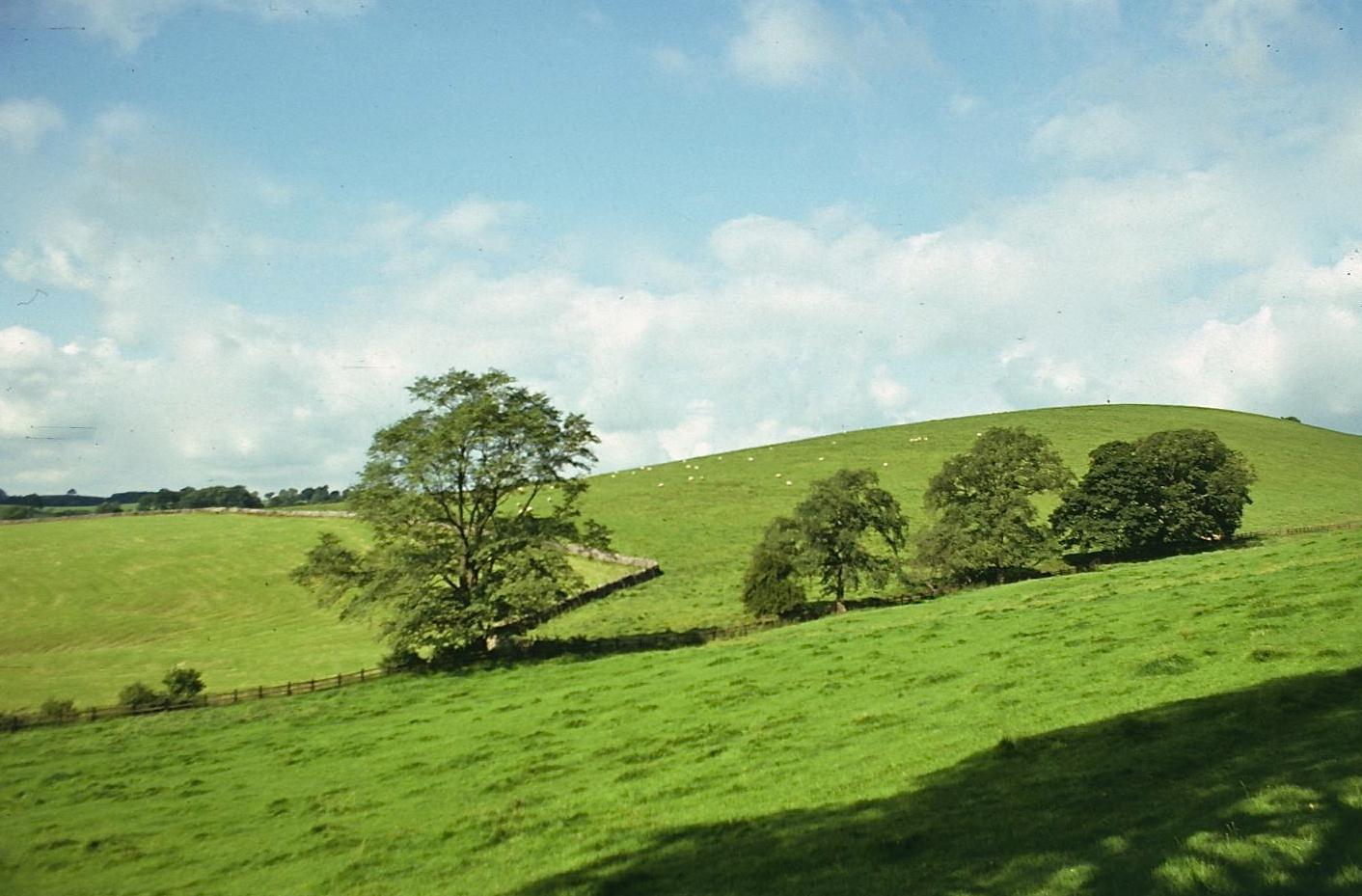
Flecks of white sheep dotted the rolling green hills of the Aire Valley and high clouds speckled the lush geometric surfaces with small shadows. It was an enchanting prospect. I sat down and had a drink of water from my canteen. I had completed my first Pennine mile!
When it was time to resume my advance on the Aire itself, the problems began. Although I expected to proceed along the ridge in a northwesterly fashion I soon realized that this would not be possible. Barbed wire fences were stretched over the hill and just where I expected to walk a young farmer was raising a cloud of dust with a tractor. I pretended I knew where I was going and followed a furrow in a northeasterly direction to a gate in a wall. On the other side I was greeted by the spectacular panorama of limestone country to the north. I could see the Aire and identify several sites on the OS map, but on the ground there was no evidence of a path and no indication how best to continue. I knew where I was, but I was still lost! Later I realized that I should have turned left at the wall, but at the time I was somewhat panicky over having lost the route so quickly, and so I decided I had better return to the comforts of civilization as soon as possible.
I hopped a low wall below me, always a sign of desperation, and descended over some rough ground to a dirt road coming from Throstle Nest Farm. A young lady was walking a dog along this lane and I grinned bravely – as if to indicate that I knew precisely what I was doing here. This plucky ploy was momentarily successful, but it was obvious that it would not convince the farmer, upon whose land I was undoubtedly trespassing. He was working in his yard and spoke to me as I neared him – “Looking for the Pennine Way?” It was time to come clean. He asked me what direction I was taking and advised my how to rejoin my route. I thanked him and used the farm’s access track to reach a tarmac road which, after fifteen minutes, brought me up alongside the Aire. I do not enjoy walking along such paved surfaces – which are hard on the feet – and it was a nuisance to be overtaken by whizzing motorcars. I almost missed my reunion with the Pennine Way, snaking down Eshton Moor behind me, but I spotted a real path leading down to a tiny footbridge over the river and I took this to return to the correct line of march.
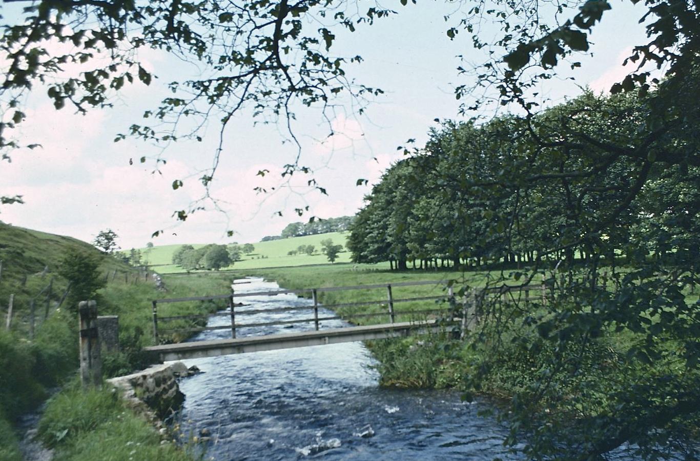
Footbridge over the River Aire
I had a rest beside the sparkling blue waters and reflected on my recent discomfiture. In fact, the route was now plain on the ground and throughout the rest of this first Pennine trip I never again went missing, but the anxiety of my recent minor misadventure weighed on my mind and no doubt contributed to bringing this first expedition to an early conclusion. But this moment was still several days off and far from the center of my thoughts as I resumed my way north, walking beside the river in the warm sun.
At the Newfield Bridge I regained the east bank of the Aire and passed along an incredibly clear stretch of water, full of lovely river plants. At Airton I left the Pennine Way momentarily and walked up into the village on the opposite bank, but the recommended sites recorded in my do-it-yourself Pennine typescript were not immediately in evidence and, wishing to conserve energy, I returned to the east bank and continued north to Hanlith. Not only was I the lone Pennine walker hereabouts, but I began to encounter day-tripping tourists tripping me up, blocking the footpath with their sunbathing and picnicking. The indolent postures of these slackers earned only a lip-curling sneer from Mr. Outdoorsman.
At 1:30 or so it was time for another detour, though this one was planned. I walked away from the river along a paved road which soon brought me to the hamlet of Kirkby Malham, about a quarter of a mile west of the Hanlith Bridge. Perhaps I had read something about the history or the architecture of this place, but when I arrived I immediately forgot all the passions of the scholar as I took in the prospect of the Victoria Inn, a tidy whitewashed structure charmingly decorated with hanging flowerpots. Suddenly I was very thirsty. I was a bit worried that I had arrived too late to be served, but a woman soon appeared behind the bar. I ordered a pint of lager. “May I take this outside?” I asked. “If you remember to return the glass,” she responded sternly.
There were some benches across the road. I drank the cold beer and ate some crisps. This was a moment of happy satisfaction for me. In spite of the late start and the wrong turnings, I was not too far off schedule. I had only a little over a mile to go to reach my hotel in Malham and there would be time for an afternoon excursion as well. I was delighted by the rhythm of the march, even by the mundane business of stile hopping or the sport of cow-pat evasion. My feet were a bit hot, but not really sore. I was certain I could get through to the end of my first Pennine day without further mishap.
Many years later I could observe one or two ironies in the happy accident of having enjoyed my very first footpath pit stop in the village of Kirkby Malham. For this hamlet later became the headquarters for a baggage transfer firm I relied on while completing other walks, Brigantes, and it was to serve as the home of another American author famous for his own walking excursions, Bill Bryson.
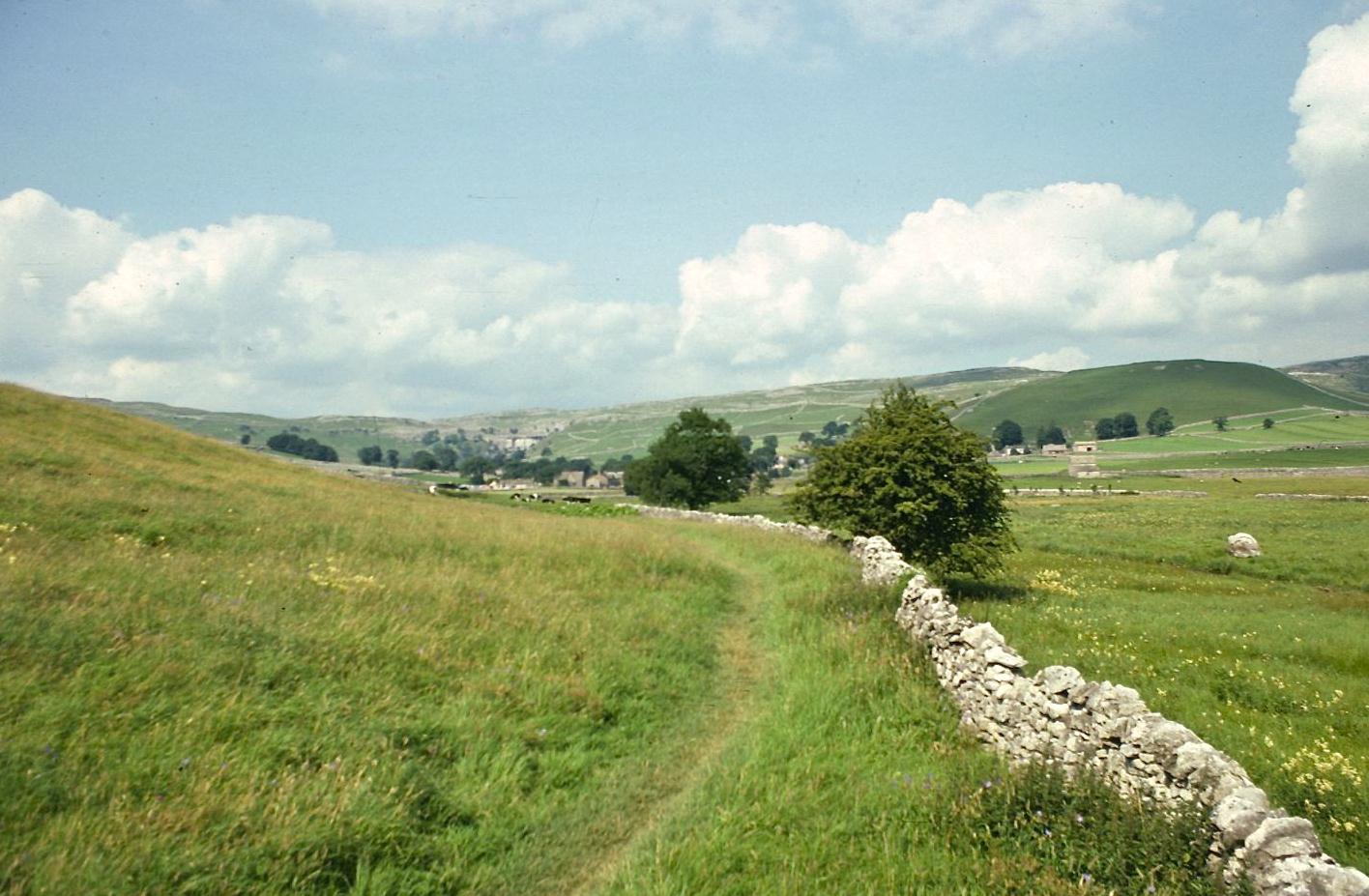
Approaching Malham
Sheep were grazing the tombstones of the churchyard, indeed some were napping between the graves, as I left along the highway to Malham. I had read about a shortcut that could be used to reach the riverside path without returning to Hanlith Bridge and I was pleased to discover this on the ground. I rejoined the official route near a barn which housed battery hens. My way now lay across a large open space, the path in tandem with low stone walls and, ahead, Malham’s cottages shimmering in the mid-afternoon sun. On the strength of my lager fuel I breezed into my first Pennine Way terminus at about 2:30.
I didn’t see any of the colonizing artists I had been promised in the guidebooks, just a lot of tourists strolling about this very attractive Yorkshire village. After crossing a little humped-back bridge I was able to glimpse the large stone edifice that was the Listers Arms Hotel where (in 1974) I paid £2.32 (including VAT) for bed and breakfast.
The hotel was locked up tight. I walked around behind and found a small boy watching a lorryman delivering beer. I advised the lad of my presence and he fetched the innkeeper, Mr. Hill. I entered the Listers Arms through the kitchen, signed in, and was taken to my room on the first floor. I threw off my pack and flopped onto a large bed whose concave mattress swallowed me in a single gulp. Here I remained for only fifteen minutes or so. Outside my window open wooden gutters carried water from my washbasin into the garden below. Tents were pitched in the next field and the trees at the end of the dale screened the region’s most famous attraction, Malham Cove. I decided to postpone my visit to this site for the next day, since I was scheduled to ascend the Cove as part of tomorrow’s itinerary. Instead I used the last two hours of the afternoon to visit another noteworthy attraction, some mile and a half to the east, Gordale Scar.
I had first read about this cleft in the steep limestone not in any guidebook but in Margaret Drabble’s novel, The Waterfall; indeed a lonely walk beside the rushing waters and leaping cascades actually brings this book to its conclusion. To reach the site I had to ascend a steep hill on tarmac. Gordale itself was not at all what I had expected. Dozens of cars choked the road and day-trippers scrambled over every inch and some of these folk were wading in Gordale Beck, plucking watercress from the shallows. I went a bit upstream and knelt to take a drink of water, a reckless gesture some would say, for the general rule seems to be, don’t drink water from the Pennine streams, no matter how inviting. I enjoyed a Cadbury’s Bourneville chocolate bar while sitting on a rock and tried to get a tourist-free shot of the falls in my viewfinder. I was unsuccessful. Somewhat fed up with Margaret Drabble I escaped to Janet’s Foss, a very lovely waterfall on the opposite side of the road. Anyway, my pedantic soul cried out, the novelist had added an extra “e” to Gordale and neglected a necessary one in her spelling of the Aire!
Had I possessed the right guidebook I could have continued along Gordale Beck on my return journey to Malham. But I knew nothing of this route and so I had to abandon my shady seat by the side of the wonderful pool at the foot of Janet’s Foss and re-climb the hill. The tourists were now stopping their cars to ask me for directions.
In Malham I wandered around, finishing a roll of film, drinking a tepid cola, and writing some postcards. Mr. Hill had given me a key to the front door of the Listers Arms and I let myself in and prepared to enjoy my first Pennine Way bath. How wonderful it is to relax in warm suds at the end of a day’s outing. For me this had been an easy half-day, just six or so miles from Gargrave to Malham, but with all the side excursions at either end, not to mention distance added on for wandering off route, I had covered almost twice that distance. I had one little blister at the tip of an adhesive swathed toe but otherwise I had survived satisfactorily and therefore I was primed for day two of my excursion, a far more strenuous fifteen miles in much wilder territory over far steeper terrain. My excitement and my anxiety level were already on the rise.
I always make a habit of bringing with me an entirely fresh set of clothes for the end of the day. On this first trip I had chosen, don’t ask me why, a pair of grey and maroon tartan flannel trousers with flared cuffs and a blue turtleneck sweater – items least likely to wrinkle in my pack. I also had a pair of extremely lightweight brown and tan deck shoes with waffled soles; what bliss to slip into these after a day in heavy boots.
The pub was open down below and Mr. Hill pulled me a pint of lager. We chatted about my Pennine Way ambitions and he seemed quite impressed – but my fatigue was draining my emotional energy and I went from this buoyant moment on the bar stool to one of utter dejection in the dining room. Mr. Hill had placed me here while he rustled up Scotch broth and rump steak and chips for my evening meal. I found the idea of being the only human in this large enclosed space especially dispiriting: the solitary meal is the greatest curse of the unaccompanied walker and I was relieved to finish my food and return to the bar where I sipped another beer and listened to the locals chatter about their day trip to Morecambe Bay.
I returned to my room some time after 9:00 but soon discovered that it was perched directly above the hum of the pub scene – augmented now by a juke box which endlessly repeated the latest George McCrae hit from the American pop charts. This meant that I didn’t fall off until the pub closed – and even then it was not an uninterrupted sleep, for it was necessary to off-load some of the day’s lager at 4:30. Nevertheless I felt reasonably refreshed when, at 7:30, I woke up to face Day Two.
To continue with the next stage of the walk you need: