
November 13, 1981: Princes Risborough to Tring Station
Chequers
Only eight days after completing a sixth day on the Ridgeway I set out again one Friday morning – still hoping to bring the walk to a conclusion before being driven from the trail by wintry blasts. I was up shortly before 6:00 in order to shave and make my sandwiches. Today was the first morning in which I did not use Paddington Station; instead I walked through the darkness to the Ladbroke Grove tube stop and boarded a train for Edgware Road. The exit I had scouted out the previous week was closed so I had to walk the long way round to Marylebone Station. It was still only 6:50, so I thought I would try for an earlier train than the 7:31. The ticket booth was still closed but a platform guard wrote out a ticket for me on the 7:04 – which soon began a milk run over the route Tony and I had completed in darkness the previous week. Today it was clear and sunny, though again quite chilly.
The latter stages of the ride had the accompaniment of a number of shrieking school boys. (How terrible to realize that only a few weeks after this journey, that is on December 12th, three of their company died when the 7:31 crashed during a blizzard into the rear of a stationary goods train near Seer Green.)
I arrived at Princes Risborough at 8:20 and, after a loo stop, left the station at 8:25 – again a very early start. It was my hope that by taking the earlier train I might be in a position to take the 3:17 bus from Wigginton – my goal this day. How much faster the stretch through Princes Risborough itself seemed to go today, when I was fresh, than last week, when Tony and I were dragging at the end of the day.
Just before reaching the parking lot turn off I paused to get my camera and an apple out of my pack. Armed with Jennett and Westacott I then climbed the hill past the lollipop man who had given us directions last time, and reached the Upper Icknield Way. I rolled up my cuffs and tightened my bootlaces and in doing so broke a lace. I didn’t have to use the spare I always carry with me because there was still enough left of the old one – but I did have to re-lace the entire boot, bent over with my pack on my back.
At the end of the lane a path began a steep ascent of Whiteleaf Hill. This yielded spectacular views of Princes Risborough and the territory beyond and I took the first of a number of photos. One of the challenges provided by today’s walk was the complexity of the route description – and it was only by trial and error that I discovered the correct line of the path through the woods on Whiteleaf Hill. On the whole, however, the waymarking (white acorns and arrows on trees) was better than I had expected; it spared me a lot of anxiety.
The woods were still resplendent in their fall colors and walking in them was a delight. A certain amount of concentration was required – not only to spot the next acorn symbol, but because the “path,” now covered in orange beech leaves, was often soft and wet beneath the surface. I took a small tumble near the Whiteleaf Car Park because a tussock which I expected to be hard proved to be just the opposite. I would have ended in the mud if I hadn’t broken my fall with the green-covered copy of Westacott’s guidebook. Several years later I got to know Hugh Westacott and I remembered to thank him for the extra assistance provided by his booklet on this occasion.
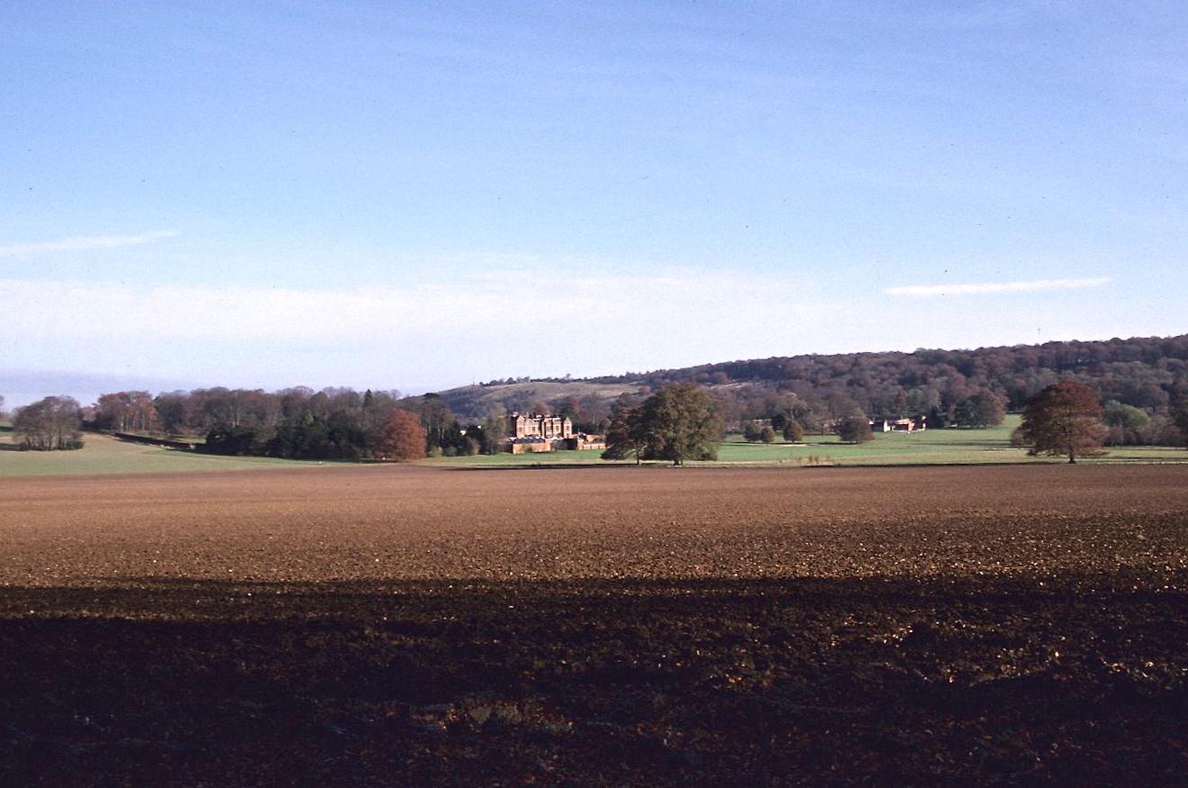
The wonderful walk through the woods came to an end with a steep, leaf-slippery descent to the Plough Inn. Then it was up a steep narrow path to a field in which, though directly opposite a Ridgeway plinth, no sign of any path was left after the most recent ploughing. I followed one of a number of tractor treads across the bare earth, though it seemed to be leading me at a somewhat more acute angle than desired. I realized I was still on route when I reached another plinth at the end. The way then continued over Chequers Nap. Jennett had warned that sections of the path were not obvious on the ground, but in this case the groove had been worn and I was soon over a stile and onto the grounds of the Prime Minister’s country estate. Chequers loomed impressively in the distance.
A long stretch of level walking was required to circumnavigate the southern perimeter of this property, mostly on grass. (Mrs. Thatcher was nowhere to be seen.) Then it was necessary to begin the ascent of Coombe Hill over a newer stretch of path – not outlined in Jennett. Fortunately the tree boles were marked for most of the route – though near the end I ran out of overt clues. It didn’t matter much since there were many paths all running out to the same spot, the monument to those who had fallen in the Boer War, one which lies at the summit of Coombe Hill, the highest viewpoint in the Chilterns.
The vista was indeed spectacular, but it was windy and cold and after changing film I had to put on my blue jacket. I wore it for the rest of the day. The descent began through a flock of Jacob sheep. I scared the shit out of some of them, literally. An easy march down the hill brought me to the quite sizeable town of Wendover around 11:30.
I took a few pictures and followed Jennett’s advice on how to get through the town along the village stream, finding it not at all complicated and quite delightful. (Westacott had
recommended walking along the highway.) I entered the Wellhead Inn at 11:50 and had a pint of McEwan’s lager, sitting in a quiet corner and starting on my sandwiches. I was prevented from getting any further into my lunch by a dog, who put her head into my lap. Her owner limped in with his pint and for twenty minutes tried to keep me from my brief period of relaxation by talking to me in the labored starts and stops and garbled diction of a stroke victim. He insisted on telling me about his walk on the Ridgeway path and he gave me detailed though essentially unintelligible directions on route finding. Then he insisted on accompanying me to Boswells, where he lived, since this was my direction and his destination. He reminded me a lot of Coronation Street’s Stan Ogden. He did rather well on the road we took at 12:20 – though my pace was certainly slower than usual.
We said goodbye in the dairy and I was soon climbing back into the woods on Cock’s Hill. There was a long green lane here and it was a bit on the tedious side. Once I tripped on a hidden root and went flying forward; long hours of watching O.J. Simpson provided me with the skill to retain my feet, though my back took a good wrenching. A long steep stretch in a deeply eroded gorge (reminding me of Southern California) brought me up to the top again near the entrance to a large cow-filled field on the Chiltern heights. Very strange to go from wild woods to such bucolic settings simply by climbing a stile. A faint path was in evidence, heading toward a radio transmitter. Then a stile was hidden between farm buildings. Actually it was a bit gray and clouds were piling up and I was worrying a little about the prospect of rain. But in another few minutes all was changed and it was sunny again.
Jennett had warned of a possible change of route through Pavis Wood so I kept a close eye on all the tree boles and emerged at last in a muck pit at the Hastoe road. There followed a mile and a half of road walking, first on tarmac, through the hamlet of Hastoe and then a hard farm road by Wickes Farm toward Wigginton. I could see that I would have plenty of time to make a 3:17 bus and, not wanting to stand around in the cold, I decided to complete part of the northern swing around Wigginton today. I found the Ridgeway path sign on the ground, face down, and tried to follow Jennett’s directions behind back gardens. Suddenly the waymarking evaporated. Nevertheless I persevered along some unlikely looking paths and at last reached the highway, as I was meant to.
Something then occurred which caused me not a little apprehension. A green bus (at 2:40) swooped over the hill, heading into Wigginton. Could that have been my bus? I decided I had better speed into town and check out the schedule, which I did. There, opposite the Greyhound pub, was the disheartening news. Since the printing of the schedule owned by the Kensington Town Hall Library a new timetable had come into effect. I had missed the last bus to Chesham and would have a long wait for one to Tring (which would have required another bus to Tring Station, anyway). In some panic over this unexpected development I decided to head for the train station on foot, since I knew it had fairly regular service back to London. After completing fourteen miles I had another two to go but I was certain there would be enough sunlight to complete the task easily.
I retraced my steps to the top of the town and climbed a stile. The route was not at all well marked here, but there weren’t too many problems as it turned out. Most of the remaining section was downhill, some still in woodland, others parts through fenced fields. In one section I was greeted by a number of dizzy horses. I crossed several highways and, just before reaching the station, the Grand Union Canal. I kept up a corking pace as I charged through the wonderful golden autumn scene. At the booking office I asked when the next Euston train would arrive. “Three minutes,” was the answer, that is at 3:48. By missing a bus I would arrive back in London even earlier than anticipated.
Once aboard I had some more lunch and some lemonade. I was quite thirsty. The compartment was again full of raucous schoolboys, now on their way home. We arrived in London at 4:35 and I began the strenuous tube ride from Euston. By reaching Tring, on the 30th day of my long-distance walking career, I had reached my 400th British mile!
To continue with the walk you need:
Day 8: Tring Station to Tring Station (via Ivinghoe Beacon)