
June 23, 1986: Brougham Castle to Pooley Bridge

Near Yanwath: the only time I ever saw a Romanway sign on this entire expedition.
On Monday, June 23, 1986, I met my walking companions, Tosh and Harold Lee, at 7:30 in Euston Station. We were gathered here to begin a five-day Lakeland excursion along the Roman Way. Dorothy was still at her post at the American College and I had determined not to bring a dog to the Lakes again (a vow that I was soon to break) – so it would just be the three of us on this expedition. The double-booking Tosh had to return for a rehearsal without completing the last day of our venture, so I tried to check on train times for her at the information window at Euston – but the clerk claimed he had no information on the little Ravenglass & Eskdale railway that she would be using. Tosh and Harold were in line for coffee when I caught up with them. Harold had made seat reservations for us but there was a momentary panic when he presented to the guard on the platform the reservations for our connecting train. Eventually we got this all sorted out and we were well ensconced in our seats at 7:45 – when the train gave a sudden jerk forward, displacing an inch of hot coffee from our opened cups onto the tabletop before us.
We reached Preston at about 10:30. (Tosh got lost momentarily when she exited from the ladies loo onto a new platform.) We had about an hour’s journey to Penrith on our second train and by this time we had just about exhausted the immediate ASL gossip – no doubt to Harold’s relief. Across the aisle a worried looking elderly gentleman in thick glasses squinted at a large-type edition of the Gospel According to Luke.
Tosh tried to use the ladies loo again when we stepped off our train at noon but some embarrassed locals had to advise her that Penrith station only had a gents! This was the week that BR and the unions admitted to sex discrimination in hiring and it was explained to us now that you didn’t need to have a ladies loo if only men were employed at the station. (Nothing in these rules about the comfort of passengers.)
Outside there were several taxis waiting. I approached the first, driven by a cheeky lad who jumped out to help us stow our gear in his boot. “This is the first taxi,” an older colleague advised from his cab nearby. “Pay no attention,” our lad replied. Good-natured threats bounced off the roofs of several intervening vehicles, but the two disputants, it transpired, were working for the same company. “You’ll have to settle this on your own,” I said, “Can you take us to Brougham Castle?”
After a few minutes ride, most of it heading east along the A66, we arrived at the impressive fortress ruins, whose ancient Roman foundations provided the starting point for our route. We spent a few minutes getting our gear ready, taking a few photographs, and rolling up our trouser legs. It was cloudy bright, with no threat of moisture. At 12:18 exactly we were ready to begin the eight-mile trek to Pooley Bridge.
My discovery of Michael Dunn’s Walking Through The Lake District (David & Charles, 1984) had opened up the prospect of another Lakeland walk, a possibility I had thought unlikely after our completion of the east-west axis of Wainwright’s Coast-to-Coast Path and the north-south orbit of The Cumbria Way. (I was yet to discover Paul Hannon’s exciting three-part circuit.) The Roman Way, as Dunn calls his route, traces the line of an ancient track created by the Romans to unite settlements in Cumbria’s northeast with those in its southwest. Existing rights of way seemed to coincide with or parallel the route of the Romans throughout – but the Roman Way had even less status than the Cumbria Way (which had at least made it onto the OS maps.) One had to hope either for very specific route-finding instructions in Dunn’s book or rights of way so clear on the ground that an ordinary knowledge of map reading might get you through. I was to be disappointed a number of times on both counts.
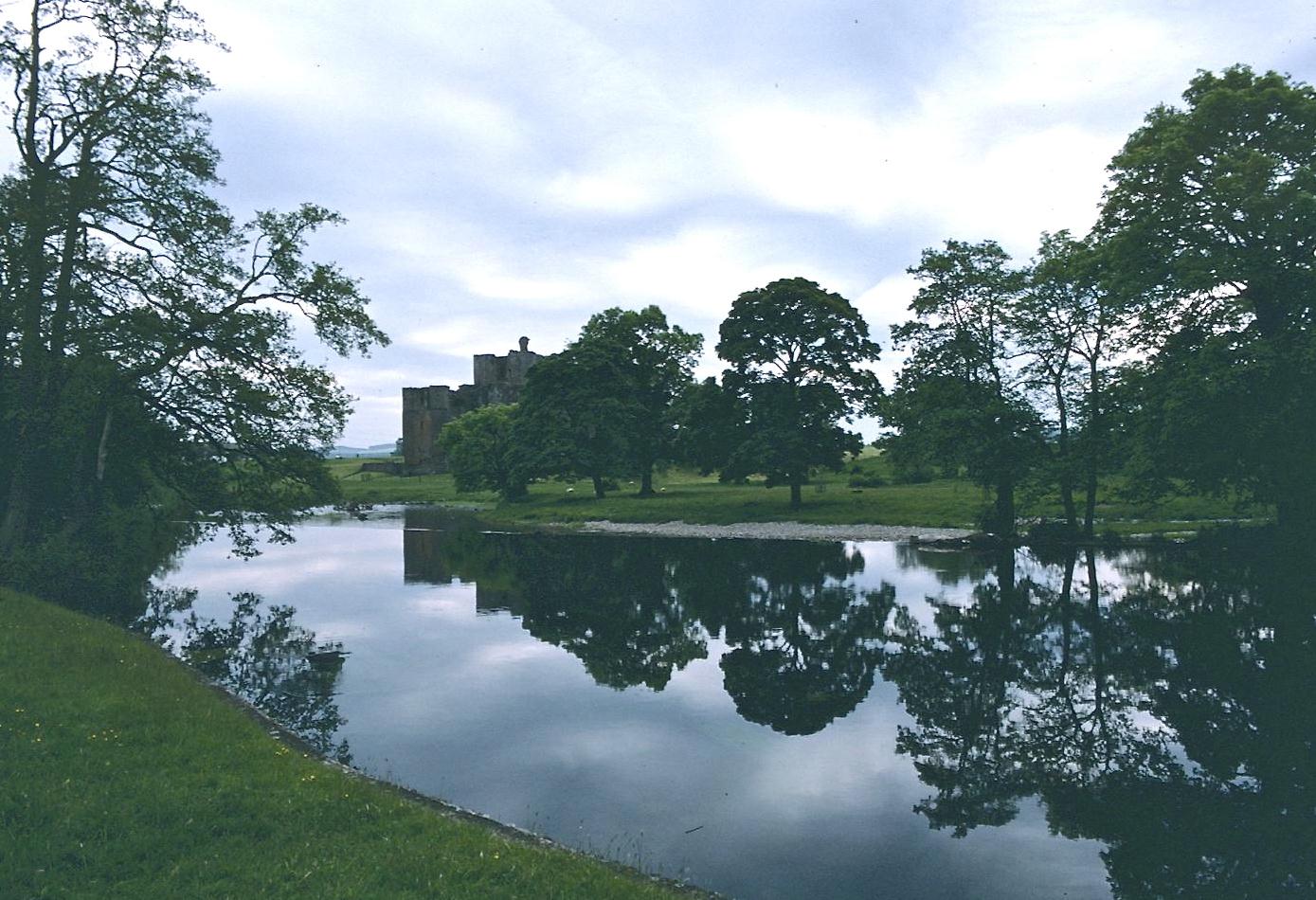
Brougham Castle and the River Eamont
We walked over a road bridge spanning the River Eamont and looked for a path along its north side. Dunn says this is found by returning briefly to the A66, but the path in question now seemed to leave from a small feeder road that tunneled beneath the main highway. To reach this ribbon of tarmac we had to retrace our steps and descend. The footpath opposite the tunnel entrance lead us through a field of cows and down to the side of the river at a property belonging to the local swimming club. Here we had another look at Brougham Castle from the north and then we began a westerly meander along the riverbank – often with very little sign of footpath.
A little sun broke through as we moved with the river away from the A66; there were several lovely cascades. We wandered through some woodland and climbed several stiles before joining an access road leading up to the next road bridge. This put is onto the highway between Penrith and points south and we turned in the latter direction to stroll though the village of Eamont Bridge – in search of a pub. In spite of our having to change trains in Preston, this was one of the advantages of a 7:45 start – it gave us a chance to get in some walking (a mile and three quarters) and still have time to get down a glass of lager and some lunch before the pubs closed. There were, in fact, two places offered at the south end of town. We chose the Beehive. Tosh had a stuffed jacket potato and Harold and I had cheeseburgers and chips.
The Australian barman advised us that there was no shop in the village, but he sold us the canned soft drinks and Mars Bars we were interested in. Then, shortly after 2:00, we returned to the bridge and took a path, signposted to Yanwath, along the south bank of the river. We left the waterside to follow a path in a southwesterly direction past the Mayburgh henge monument – with much discussion over what a henge monument actually was. The Lees, new gardeners, paused to examine each flowerbed. They were doing this as I climbed onto a track that disappeared beneath a span of the M6. On the other side it started to get harder to select a route, but I used the riverside woodland and several gates to get us west, along pathless routes suggested by dotted lines on the OS map.
Eventually I ran out of clues altogether. We were standing in a field full of cows and looking for an escape route. The large house ahead I took to be “The Grotto,” so I steered a line to the left of it and we came out on its access road, parallel with the railway line. A gate to the south beckoned and we exited here, but not before a charging Corgi had nipped at Tosh’s pant leg. A sign for walkers going in the opposite direction confirmed that we had been on the right route. But after Tosh and Harold could be coaxed from the lupines and the poppies and we had ducked under an arch carrying the rail line, the confusion really began.
To the north was Yanwath Hall. A “Romanway” sign (the only one encountered in five days of walking) pointed to a path heading directly for the village of Tirril, due south –though no such path existed on the map or in Dunn’s directions. The western route specified in the guidebook was nowhere in evidence, though I could see a gate in a fence ahead that clearly coincided with a fence line on the map. A purist, I set out for the gate, but this was probably a mistake. So was getting south of the fence when the gate was reached. As we walked forward we were met by a wire fence, which was not that easy to scramble over. There was some evidence of a stile at the northern corner of the field so we persevered on into the next field by scrambling over the rocky field corner. We continued to meet similar obstacles in each field – it was as if the right of way had languished and died.
After a while I became convinced that a farmer, who was plowing the other end of one of these fields, was coming to get us – though we were, in fact, ignored. I put a foot into one little stream and crashed into a bower of nettles as I fell forward. At one point a second stream had cut a deep gorge before us and it was dangerous to descend here so we had to retrace our steps and walk down a hillside into a riverside meadow full of what Tosh described as man-eating plants.
There was actually a path through some of these giant fronds and we used it to cross the stream and climb a hillside, where we could walk along the margins of cornfields as far as the next strand of barbed wire. The Lees patiently followed me through and over these obstacles without complaint. But when I saw a track leading from the sewage works onto a tarmaced road, I decided to call it quits.
We climbed over our last strand of wire and emerged onto a street lined with houses, a finger of Sockbridge – though this was not quite as far west as I had hoped to be. It took me a while to figure out where I was, but the church at Tirril proved to be a good landmark and, via roads, we eventually reached the main Penrith-Tirril road – not far from the church. (Although it would have meant more road walking I was sorry by this time that I hadn’t taken the advice on the signpost at the railway arch!) It had become warm enough for me to walk in a t-shirt and my bare left arm was speckled in nettle rash, a tingling that lasted until the next morning. The Eamont walk had proved to be as difficult as that along the Calder the previous summer.
With its chapel, its reading room and its charming gardens Tirril was quite a pleasant place. The Lees bought some more refreshments at the petrol station and these we consumed on benches outside the closed Queen’s Head. It must have been about 4:00 that we got going again, heading west on the highway, passing the entrance to a new housing estate, and turning south on the tarmaced road to Celleron. Here we began the only ascent of the day – rising gradually with no traffic to worry about to reach a junction near some farm buildings.
For the way forward there appeared two possibilities, one through an inviting gate onto open fellside and the second, also through a gate, into a series of fields. The right hand option, I could see, would put us on the wrong side of the plantation facing us and also encourage us to head west too soon. Our path therefore had to be along the left side of the woods through the cows – with very little evidence of use. Our passage uphill at this stage was also menaced by the presence of a very large brown bull, lying in the grass not far from our route. Fortunately he seemed to be quite a docile Ferdinand and we had no problem tiptoeing around him. “How long do you suppose it would take us to hop this fence?” Tosh inquired. There was a gate at the top of the field and we had to untie a rope to get out. I told Harold he must retie the knot so the farmer would never know we had been here.
The farm in question, Winder Hill, was now reached along its access track. Sheep were being moved directly onto our path as we entered the farmyard. Here, too, there seemed to be two escape routes and again I disdained the more westerly of these alternatives in order to continue uphill. Sheep had to be nudged away from our gate but at last we were out on open moorland. There wasn’t much evidence of a path, but I navigated by using the woodlands as guides. When we had gone south far enough we reached the crest of the hill and got a marvelous view of Pooley Bridge at the head of silvery Ullswater. The sun had definitely broken through now.
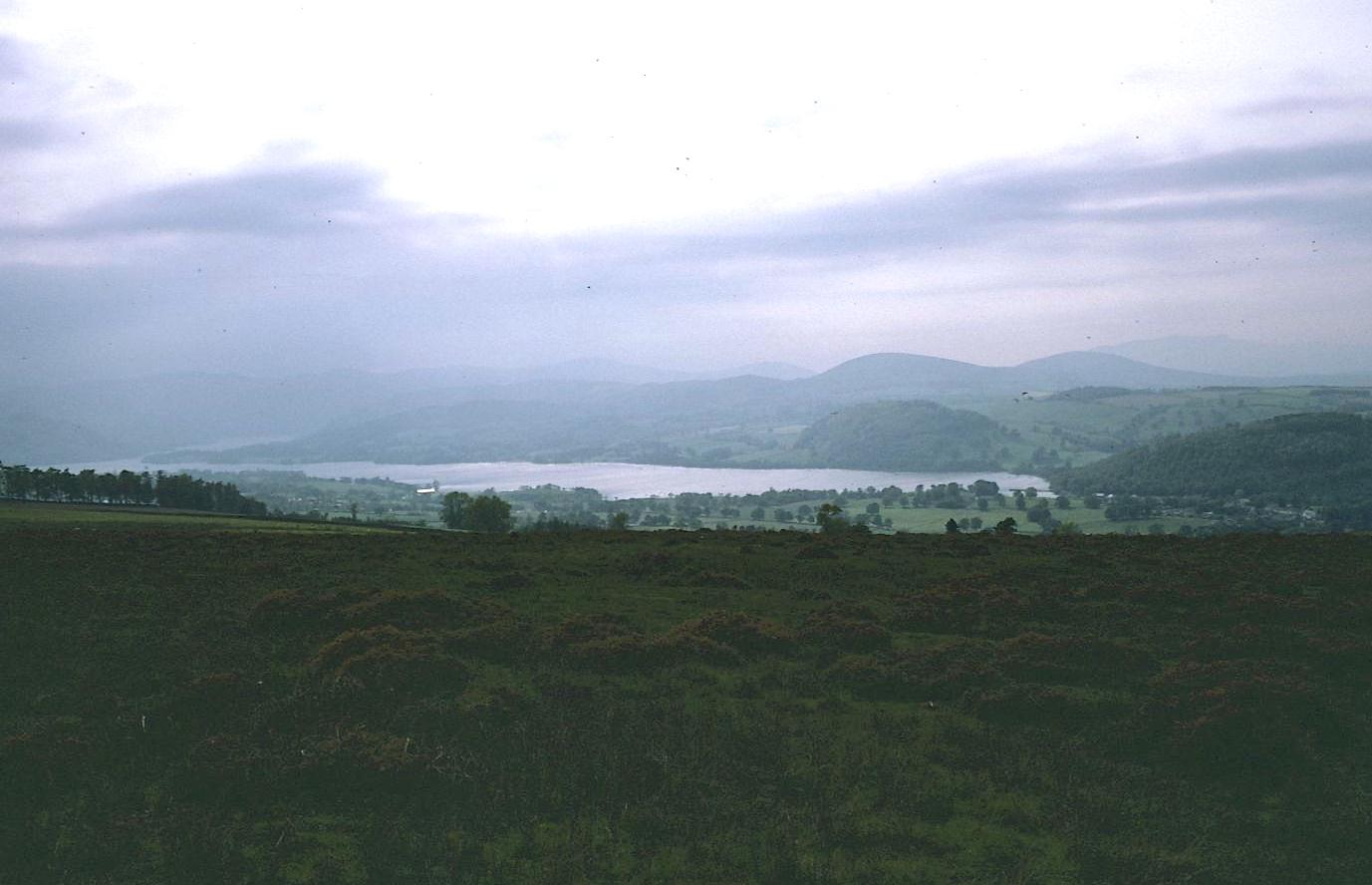
Ullswater from Heughscar Hill
We pressed forward and finally regained a quite well-trodden Roman route on Heughscar Hill – but I decided to use a shortcut down to off-route Pooley Bridge, following a track along a finger of woods that had climbed over hill from Roehead Farm. This was a steep, toe-twanging descent, but we finally rejoined the Moor Divock road, the one that we had used two years before, and made it into Pooley Bridge by 5:30.
We had reservations at the Swiss Chalet, the same place where he had taken refuge against the rain on the day of our Ullswater boat ride. Each of the rooms here was named after a different canton – I had, appropriately, Bern. I took a shower and sifted through my pack. I phoned Dorothy and bought some postcards and met the Lees for drinks in a bar full of young men out of Aufwiedersehen, Pet. We shrank from their mirthless guffaws and eventually went into the dining room for pea soup and a Zurich ham specialty, all of it over-salted. There was only one other table occupied – also by Americans – a man in his sixties and a girl in her twenties. Tosh was fascinated by their relationship – for they were holding hands – and somewhat scandalized when I suggested they were man and wife. This I concluded from snatches of overheard conversation. He had concluded a description of his World War II adventures in New Mexico with the phrase, “Your husband has lead a very varied life.” She, a chubby gummy blonde child wife who wanted iced tea, had answered, “That was then; this is now.”
We all had a gooey desert and tried to shut out the sound of the yodeling records, which were relentless. The other couple liked them and tried to find out where they could get a copy of the tape. Tosh regretted that Dorothy was not here to give her opinions on the odd couple. They drove off as we were having a little walk over the bridge and we never saw them again. It was a little chilly, so we returned to the hotel and turned in. I ordered some packed lunches and did a puzzle from last year’s magazine. I had discovered that I had forgotten my sleeping pills but I had my earplugs (against any more yodeling down below) and eventually I fell asleep anyway.
To continue with the next stage of our walk you need: