
June 26, 1986: Little Langdale to Boot
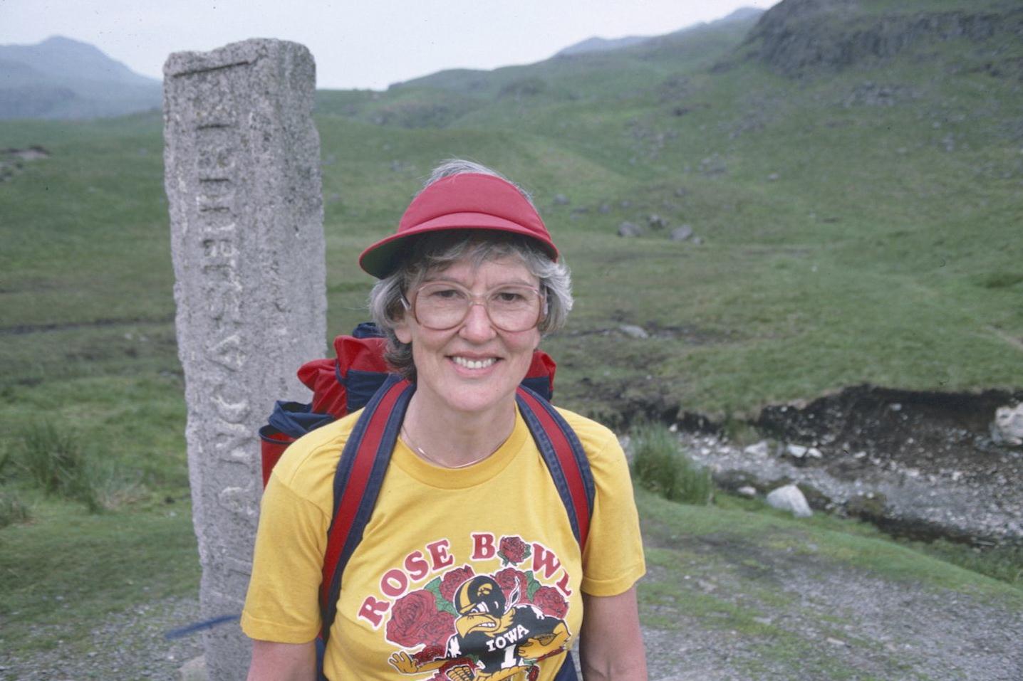
In her Iowa t-shirt Tosh celebrates 400 miles on British footpaths at the Three Shires Stone. This shot was also used as an illustration in A Walker’s Alphabet.
I completed all my preparations, including taping over the latest blisters, and took all my equipment with me – including camera, brown corduroy cap and walking stick – when I walked up to the main building at 8:15. All of this gear was deposited in the Lee’s room and the three of us descended to a lonely breakfast room – eventually filled with a mostly geriatric and female company, all of whom seemed to be doing some short walking trips using the Three Shires as a base. We had a delicious breakfast, collected our packed lunches, and began our walk at about 9:20.
Hazy sunshine hovered overhead from beginning to end today and at Little Langdale’s village shop and post office Tosh tried (unsuccessfully) to buy some additional sunscreen. She and Harold did the entire day in shorts. We had to do a great deal of road walking today, for, though rights of way do exist alongside the motor route over Wrynose Pass and Dunn also indicates the existence of a path starting at the Pedder Stone, I was never able to discover such a path – though I left the road several times to look.
Things were not too bad as we completed the first mile to the Blea Tarn turnoff and descended to round a corner at Fell Foot Farm. We had lovely views of Little Langdale Tarn and the end of the glaciated valley, now behind us, and, to Tosh’s alarm, we could already see cars climbing abruptly to the pass ahead. We were soon doing some steep stepping in the hot sun and we took advantage of a large boulder in order to sit down in its shade, opposite the Blea Tarn road. Here we drank some water.
Then we pushed on past the Pedder Stone and reached the bridge over Wrynose Beck. I ascended this for some distance, looking for a path, but I never found a satisfactory one and, after a rest, we rejoined the “motorized lunacy,” as Dunn calls it, to walk the macadam up to the top of Wrynose Pass. All in all, things went pretty quickly. At every lay-bay there was a Mountaingoat bus parked, with gawking tourists expressing enthusiasm over the views –which, in the morning haze (no doubt thickened by all the car exhaust) – were quite indifferent. In fact, with our gear and our determined pace, it was obvious that we were the Lakeland sights the tourists were most interested in.
As we cleared the long summit plateau we encountered the famous Three Shires Stone itself – once the county boundary of Westmorland, Lancashire, and Cumberland – today practically hidden between two red sedans parked here for the view. When one of these vehicles pulled out I posed Tosh against the pillar because this spot marked mile 400 in her long-distance walking career.
We began the steep descent, reminding one another of cars ahead or behind; this was not particularly pleasant walking, though we were encouraged by the views of the Dudden Valley and Hardknott Pass in the distance. By the time we had reached the valley bottom and been joined by the Duddon itself I had again done a thorough visual search of the opposite bank, looking for a ford and a path along the river’s north side – but again I failed. We walked down to the riverside anyway and had some lunch, a very pleasant spot.
Then it was more road walking, but more straightforward and fast, as far as the Cockley Beck bridge – where the Lees insisted that I appear in at least one photograph. Here was a genuine turnoff from the road (which continued over Hardknott Pass) a track to the old Black Hall Youth Hostel, now reclaimed for farming and housing a motley collection of unhappy guard dogs, some in the rafters of the barn, snarling on their chains, others curiously loose at our feet as we walked around looking for the start of a pedestrian path to the top of the pass. Tosh used an old outside loo left over from youth hostel days.
I think we should have taken the first opportunity to get behind and above the farm (there was an early exit on the right and it would have allowed us to escape even sooner the appallingly mistreated dogs). We went instead though the farmyard and out a gate, across a field and up to a second gate, which we had to climb to get to a path behind the farm. I scouted along this while the Lees were still scrambling over the gate behind me, but I never found any path (let alone a carefully zigzagging one) – as Dunn had promised. The way forward was clear enough, with the pine plantation on the left providing a good guidepost. One simply had to follow its wall to the top.
I took my own zigzags – looking for a real path – and passed two magnificent rams on the way. The footing was quite juicy and we were fortunate it had not rained lately. Tosh and Harold were quite some distance behind me, but eventually they caught up and we climbed a giant ladder stile over a stone wall and completed the last of our progress to the top of the plantation, amid delightful rocky outcrops. Tosh now raced ahead to get the first view of Eskdale and we began a diagonal descent to the motor road. When it came in sight below us we chose an excellent spot for a second lunch, with Hardknott Castle just ahead of us – a mile or so to the west. I took off my boots and let my hot feet cool off in the grass. I thus discovered a spot that needed more tape.
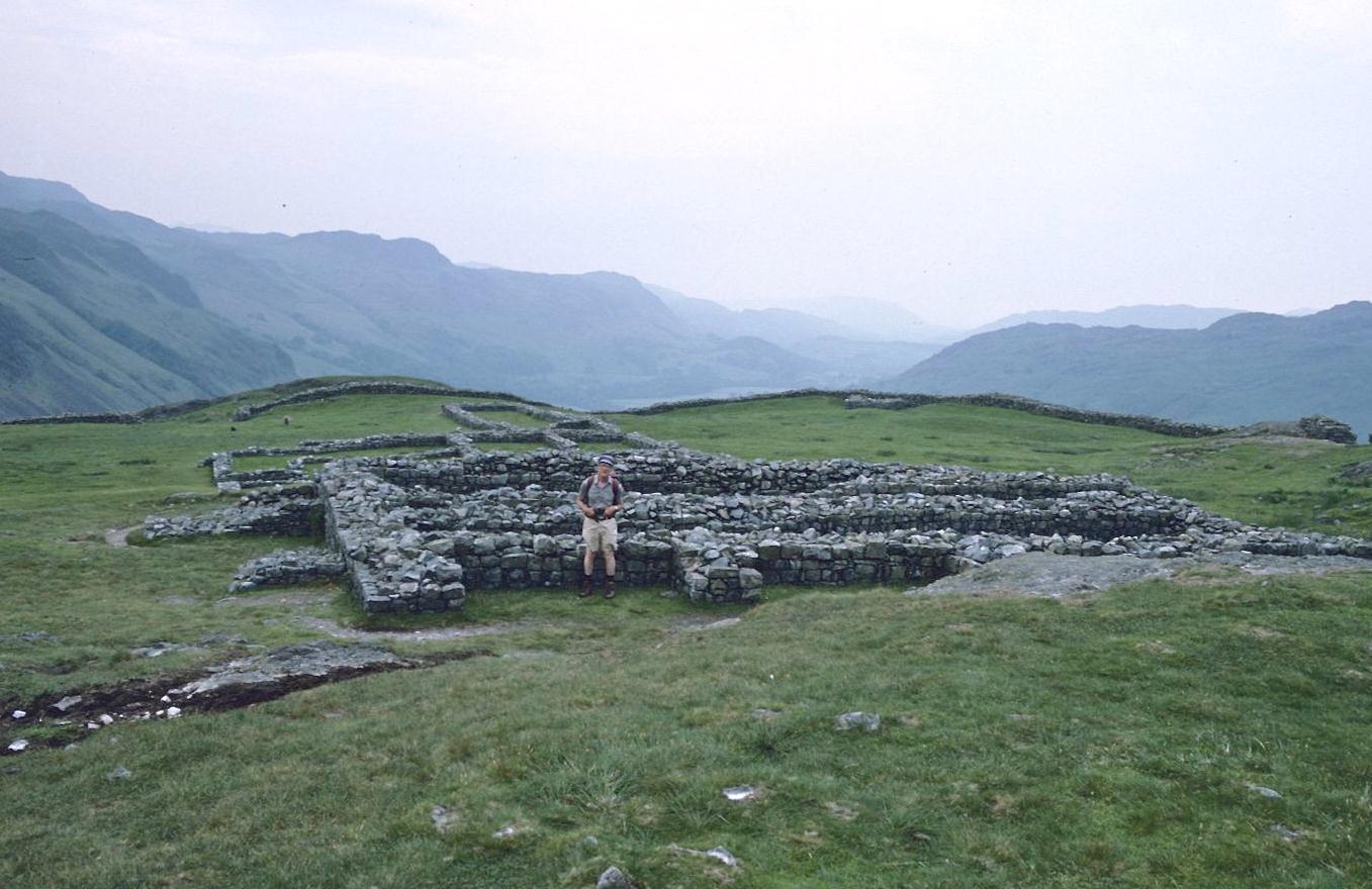
Harold at Hardknott Castle
We then scrambled down to the road, just at a spot where a stream crossed. I climbed down to it to refill Harold’s canteen – as we were getting low on liquid on such a warm day. Then we continued along, down the steep motor road from Hardknott Pass, escaping some of the twists by heading out on a path that circled around to arrive at Hardknott Castle via rough, wet ground north of the road. I say path for, again, one is promised in Dunn, but we found nothing on the ground and had to improvise – with the fort itself as our marker. This very impressive Roman ruin was reached in due course and here I took Harold’s picture in honor of his 400th mile, reached here. It was 3:00 or so and there wasn’t another soul at the site when we arrived.
A steep descent from the southernmost corner of the wall brought us back to the highway and we did one last stretch of road walking to reach a cattle grid and a turnoff over another charming bridge. We followed an old packhorse track here but shortly after the bridge one branch departed to follow the infant Esk (though hidden most of the time by a screen of trees) and we took this fork, stopping almost immediately for a rest at the first shade tree. Thereafter, as we worked our way westward without great difficulty, we were often grateful to be in woods – for open stretches in the sun were quite oppressive. Several streams crossed our path, draining the steep flanks of Harter Fell. At one of these, supplied with a footbridge, we had another rest. Tosh even took off her boots and put her feet in the water.
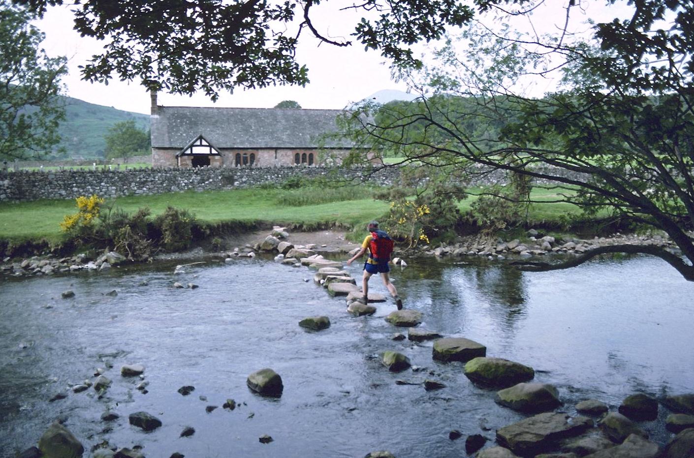
Stepping stones over the River Esk near Boot
Near Penny Hill Farm there was some marvelous old farm machinery abandoned to rust; the farm itself – described as spartan by Tosh, who had a glimpse inside as we walked by – gave access to a lane down to the Esk at the Doctor Bridge. Two youngsters from the farm were returning from a swim here and we had a long rest on the north bank of the river (where I soaked my head) before returning to the south bank to follow our track by Low Birker farm and additional woodland. Views of the fell-cradled valley were superb and none better that that from a little tarn, screened from the path by pines, just off the route to the south. Our map contained no reference to Birker Beck, our turnoff, but I chose a spot at a footpath sign and took a small track downhill to the Esk again – just at the stepping stones needed to cross to St. Catherine’s church, opposite. We crossed the river on these stones and proceeded along lanes to the motor road, where we discovered the vine-covered walls of Boot’s Brook House – our immediate destination. It was 5:20.
We were shown to our rooms and bathed. Then we met in the little bar for drinks and at 7:00 went into dinner – sweet and sour pork and Chinese cabbage – most unusual b&b fare. As a matter of fact, no one had offered us lamb at all on this trip – but then this was a period following April’s explosions at Chernobyl – when excessive radiation had been detected even in the local flocks.
We had a tour of Boot after dinner and a drink at the Burnmoor Inn. It was a lovely warm summer evening, idyllic. I phoned Dorothy one last time and also said goodbye to Tosh, who now had to return to London – early next morning– starting on the Eskdale and Ravenglass railway, in order to make her rehearsal. The only music I heard was from a teenage transistor in the street below. “Well no one wants an ugly girl,” was the topic of conversation accompanying this serenade.
To continue with the next stage of our walk you need: