
June 28, 2001: Rye to Winchelsea
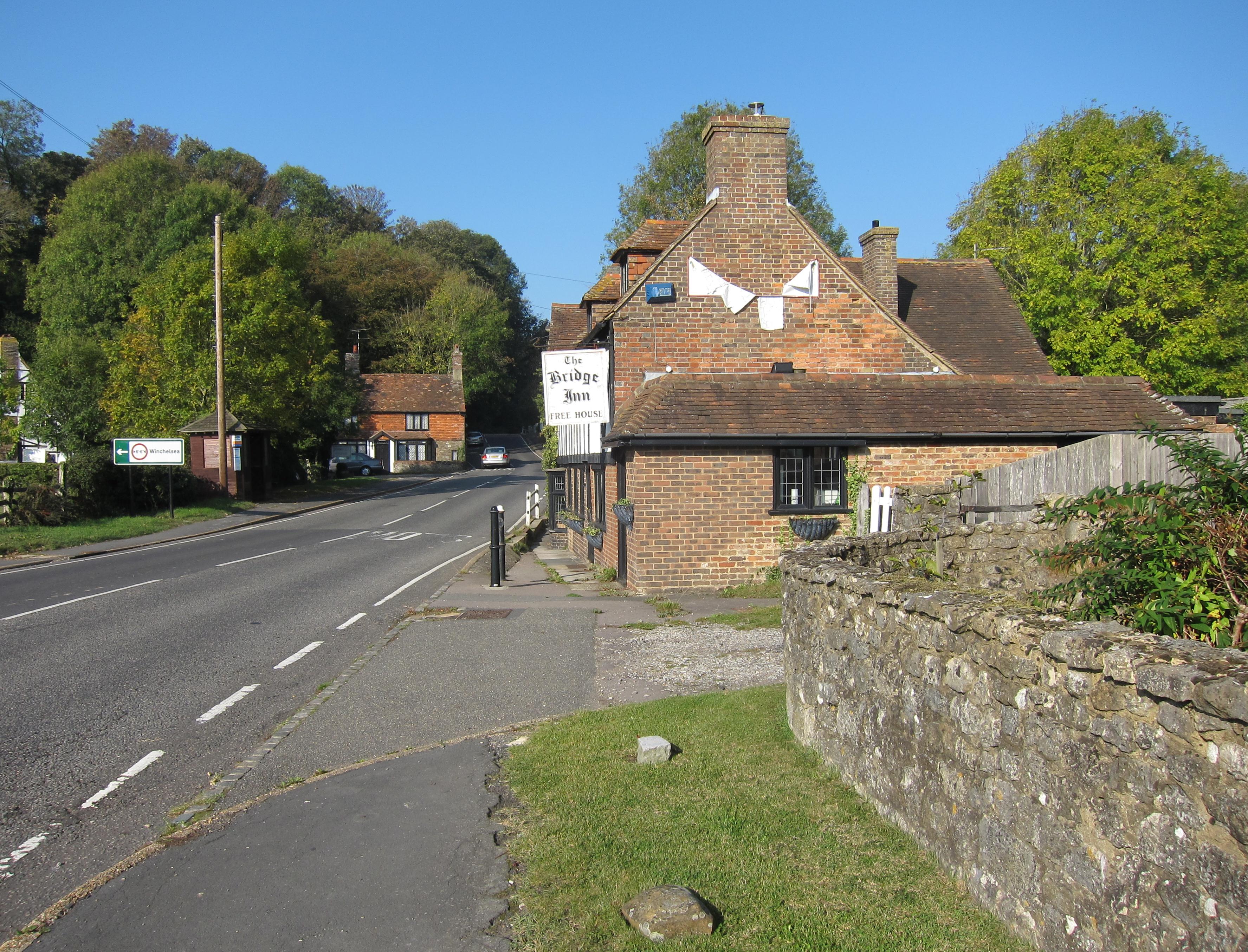
The Bridge Inn, Winchelsea
For our second outing in the much-delayed walking season of 2001 I now proposed that we attempt to complete the last stage of the Saxon Shore Way. I had checked a government map on the Internet to see if there were foot and mouth closures in the area, but all of it seemed to be “provisionally open.” A lot of travel time is needed to get all the way to the south coast, to walk twelve miles, and to return at the end – so this seemed to be a good time of year to travel because there was so much daylight. The Lees and I were even considering the idea of having our evening meal in Hastings, at the end of the route, before returning to London.
I met my companions in Charing Cross Station, where I had just bought a day return to Hastings –using my senior rail card, which I had renewed in May. I went into the Whistle Stop market for two bananas, a Snickers bar, some sesame crackers and a bottle of water – for which, I determined afterwards, I was monstrously overcharged. The Lees were pursuing coffee, which I disdained this time, and we soon boarded a 9:30 train for Dover.
There was plenty of time for school gossip (Dorothy’s recent retirement at the top of the agenda) as we sped toward Ashford International. I drank my bottle of water. A Hastings train was waiting for us and shortly after 11:00 we were off for Rye, which we reached within twenty minutes. It was alarmingly grey outside, not what I had expected from weather forecasts at all, and when we left Rye station there was a real mist descending.
We headed for the public loos across the street and I put on my rain jacket and loaded the guidebook into my new map case in the doorway. My task was now to get us back to the spot where we had entered Rye last November. I improvised a route that seemed to work – but it was obvious that a number of changes had taken place hereabouts, particularly in the traffic flow, which now included an endless series of coach parties being ferried about the town in juggernaut buses. Against the stream of this traffic we marched back to the bridge that had brought us into the town and began our walk, back on the SSW again, on a pavement between a park and some local fisheries.
We then dodged across another highway and climbed some steps in the direction of Ypres Tower. Guidebooks are often rather unhelpful when it comes to urban sections of the route and at the top I soon ran out of useful hints in Bea Cowan’s volume. This didn’t bother me nearly as much as the rain, which kept up a steady spray. I had the OS map in the book to help me with my own improvisation through a town that clearly had a great deal of charm – particularly for the French, who seemed to be here in great numbers today.
We walked down the hill and rejoined the traffic for a hairpin that took us southeast, opposite the mist-shrouded town. At this point, in the shelter of an overhanging bush, we all paused to put on our rain pants as well. This was not at all what I had expected from the weather forecast. We turned off on the Rye Harbor road and crossed a lock gate over the River Brede. On the gravel track to Castle Mill Cottages we saw something else unexpected, a hand lettered sign indicating that footpaths were still closed. It was leaning up against a field gate (not our route) at right angles to the road (it would have been easy to miss it) and there was no way of telling how long it had been there or whether it was still accurate. We turned off at the cottages, as advised, finding no sign at all. We walked forward on a grassy and soon overgrown embankment, with fields on the left and the Brede on the right – but Tosh was already getting nervous about our right to be here.
We persevered on tracks that lead us in the direction of the ruinous Camber Castle, encountering turnoff points and a stile that took us closer to the monument – but nothing to indicate that we didn’t belong here. The same wind that had whipped rain into our faces now began to dry us off and I opened my rain jacket so that the breeze could get at my wet t-shirt. The skies were getting brighter and it did not rain again this day. We returned to civilization after two miles of rather bleak marshland and I was eager to see what signs had to say at this end. We did discover one or two of interest. One was from a local angling club suggesting that its waters were still closed and a second was from a nature trust suggesting that, though its paths here were not “officially” closed, they preferred that the public stay away.
All this was very perplexing. We passed by several farms and took a wrong turn (a SSW blue arrow having led us astray), ending up at sewage works instead of reaching the head of Sea Road – as we had intended. Tosh was complaining about hunger as we returned to the highway, heading west toward Winchelsea, where I expected to encounter a pub. Just before reaching a junction with the A259 I crossed the street to see a sign just at the spot where I expected our route would continue after lunch. It too was from a local angling club and it too advised that its waters were closed. Still puzzled I followed the Lees into the friendly confines of the Bridge Inn. It was 1:30.
Tosh had a stilton ploughman’s and Harold and I had egg, beans and chips. My feet were wet, of course, and I kept my rain pants on. The publican was a very accommodating chap who was soon called on to assist an elderly lady whose car had broken down up the hill – she was having a difficult time communicating with the AA in the Midlands and the landlord had to get on the phone to give directions. The stranded motorist, it appeared, was just one of a dozen geriatric ladies, all in their eighties I would say, who were just finishing up lunch in the restaurant. I drank a Diet Coke and joined the Lees in a cup of coffee.
When we emerged from the pub about 2:15 I noticed an official looking sign across the street. This was indeed from the council and it did indeed confirm that footpaths were closed. I decided to ask the publican if this warning were still in force and he confirmed that it was. He said I could walk along the military canal for the next two miles but then I would have to turn around and come back. “Let’s go home,” Tosh said. We were standing next to a bus shelter.
I was obviously quite disappointed, although I have had walks of only four miles in my walking career before this, but the next stretch, which would begin at the Bridge Inn, would now be an easily manageable eight miles. The publican thought there was a bus at quarter to and Tosh wanted to sit in the pub until then – but I was worried that we would miss the promised vehicle while we were inside. She then announced that she would get some coffee to go and actually returned to our bench across the street with two cups and saucers –which was all our host had in the matter of takeaway. “Just leave them on the bench,” he added, “if your bus comes.”
Across the way the stranded driver had gotten a ride from one of the other little old ladies (not wanting to walk up the steep hill into town) and this party now attempted to make its getaway from the parking lot. Unfortunately the driver chose to come down the steps rather than the roadway with her vehicle and there was an awful clunk as her car collapsed on an abutment. So the publican had to come out and phone the AA a second time and the first little old lady asked us to come and get her if our bus came.
It did, but we almost missed it because it came at 2:30 and we couldn’t see it speeding toward us because of the shelter itself. I held out a despairing arm at the last moment and the driver stopped. “Do you go to Hastings?” I asked. He did, and we had soon climbed to the top of a double-decker for an inland ride to our destination. I suggested we walk a bit at the end (somewhat queasy from my ride) and so we departed the bus at the seafront. There was a bit of blue in the sky but there was a chill wind blowing in our faces as we faced a pond full of empty swan boats. We marched west past endless fish and chip shops and amusement arcades while buttoned-up Britain attempted to enjoy its summer. Once again I was using the OS map in the path guide to navigate.
We passed trough some shopping precincts and climbed a hill where we at last saw the train station. It looked like our best bet was a Cannon’s Park train and so we sat in front of the station cafe for twenty minutes while the Lees drank another cup of coffee and I ate some biscuits.
Our train departed shortly before 4:00 and reached London at about 5:30. It was sunny now and I put on my new prescription sunglasses for the first time (however my eyes had stayed closed for much of the journey – as I tried to doze.) At Cannons Street it was even possible to use the underground interchange (this being a Thursday) and we were soon on our way home after a very unusual outing indeed.
To continue with the next stage of our walk you need: