
August 18, 1992: Ivybridge to Holne
Gavan heads for the track of the Redlake tramway
On Tuesday, August 18th, I began to walk the Two Moors Way. This expedition was to be the third time that my former student, Gavan Meehan, would accompany me on a hundred mile summer odyssey – and he had arrived in London after a round-the-world tour with the Harvard Din & Tonics only a few days earlier.
The Two Moors Way is essentially a Devon route (although two nights are spent in Somerset); it crosses this southwestern county from Ivybridge in the south to Lynmouth in the north as it makes use of picturesque countryside in Dartmoor and Exmoor national parks. I had been interested in completing this route for a number of years, having first encountered its existence when I discovered a Two Moors Way plinth as I was out walking Toby the Schnauzer near the Bonnicott Hotel in Lynmouth on the second night of our conquest of the South West Coast Path.
At 104 miles, our footpath would be longer than the Wicklow Way by four miles and only shorter than last year’s West Highland Way by two. Undoubtedly Gavan was the only one of my walking companions with the stamina and interest to complete a route of this length in one go. But because I wanted to spend only eight days and seven nights away from London it would be necessary for us to get in a full day’s walking on day one as well as day eight. This explains why it was necessary for us to make a very early start from Maida Cale on this cloudy Tuesday.
Gavan was wearing one pair of my cords and carried another in his pack – which turned out to be my blue green and grey knapsack. He had another pair of my trousers stowed away for evening wear and he had claimed some of my t-shirts and the Harvard sweatshirt he had given me two years earlier. I was back to using my original blue backpack, purchased for my first Pennine Way trek in 1974!
A few days earlier I had purchased two second-class singles to Plymouth at Paddington, which we now reached at about 7:30. At over £40 each these were ferociously expensive (in 1992), but this was part of the price we paid for a 7:45 departure. We had seat reservations in car A and were well-ensconced with coffee and chocolate doughnuts when the train pulled out. Rain had been predicted for the southwest today and I cast many an anxious glance over a well-remembered countryside as we sped forward.
The journey lasted a little over three and a half hours. Gavan, still jet-lagged, dozed a bit after giving up on an attempt to get me interested in a table-slapping card game that had been all the rage among the Dins this summer. It would not be the last time that he would have to brood over his failure to make me 20 again.
At 11:23 we marched through the Plymouth station as I tried to get us launched on the TMW as early as possible – by engaging the first in a long line of black cabs outside. Our cabbie knew all about the start of the Two Moors Way so it was with some confidence that we arranged ourselves in the back seat for a nine-mile journey eastward to Ivybridge. Unfortunately I spent some time now trying to adjust my map cases as we sped around Plymouth roundabouts and it took some time for my stomach to settle as we drove onto the motorway. I think I held out the hope that our driver would take us to the spot where a plinth marks the southern terminus of the route – but he seemed interested only in depositing us next to a parade of shops in the village of Ivybridge and, at 11:43, we were on our own to begin our walk. The cab ride had cost £12.00.
This early start had been needed because we now had thirteen and a half miles to go, the longest distance yet attempted on the first day of an out-of-London walk. The trek began along the western banks of the River Erme (whose estuary we would wade across while doing the South West Coast Path three years later). We crossed over on a bridge to the Harford Road and began a very steep climb past a paper mill and some public buildings. Gavan got well ahead of me here but I was reasonably confident my legs would not let me down – after a month of running on the Paddington Rec track. Breathing rather heavily we reached our first plateau at a junction of routes, including one suburban street so new that it appeared neither on the Dartmoor OS map nor the official guidebook. Here we found the Two Moors Way plinth and paused for some ceremonial photos.
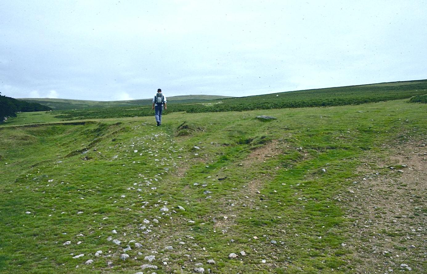
Then we walked forward, still on the Harford road, over a railway bridge – turning right opposite the elegant estate of Stowford. In spite of the predictions about rain, visibility seemed to be excellent; it was cloudy bright and there seemed to be no imminent threat of moisture. We continued up a green lane that made several twists and turns as it gained elevation. The foliage prevented any views but as we reached a gate onto the open moorland this was about to be remedied. The maps indicated a choice of routes but Gavan, after taking a compass bearing, headed us off in a northeasterly direction as we used grassy sheep-filled clearings in the bracken to climb the hillside in search of the roadbed of the old Redlake tramway. On this climb Gavan told me about his recent adventures on Hong Kong footpaths where he had encountered huge spiders and butterflies in the midst of a typhoon – but had not turned back because, he said, he had learned from me not to do so.
At the top of our climb we encountered the trackway, one that we would follow north for quite a few miles. There were a number of other people about – not TMW walkers, whom we spotted only infrequently, but rock climbers scaling the limestone tors on the ridgetop and daytrippers, including a troop of Downs Syndrome kids. Having covered about a mile and a half we sat down on a grassy bank at the edge of the trackway and had a snack and some water. Then, still gradually rising, we continued on a very firm and easy surface past Weatherdon Hill and Hangershell Rock. There were a number of Neolithic stone rows and ancient crosses still standing adjacent to our moorland track – which was increasingly dominated by wild horses. Gavan and I did speculate on what those huge black and white structures on Piles Hill might by; they turned out not to be petrified penguins but ordinary Holsteins.
The temperatures were relatively mild and visibility, as we crossed over Ugborough Moor, was excellent. While I had trained on the Paddington track I had chosen a different TMW landmark to commemorate the completion of each 100 meters and Ugborough Moor had been the first quarter-mile post. I could now suggest to Gavan that, as we had the four mile mark in our sights, that we ought to think about a lunch spot as well. It took us some time to find some rocks (not otherwise covered in sheep pellets) and here, on the flanks of Three Barrows Hill, with the infant Erme still winding its way below us, we paused for some ham and cheese sandwiches I had made this morning. I couldn’t eat both of my sandwiches (let alone the beer nuts, apples and candy bar) and two days later I had to throw it out.
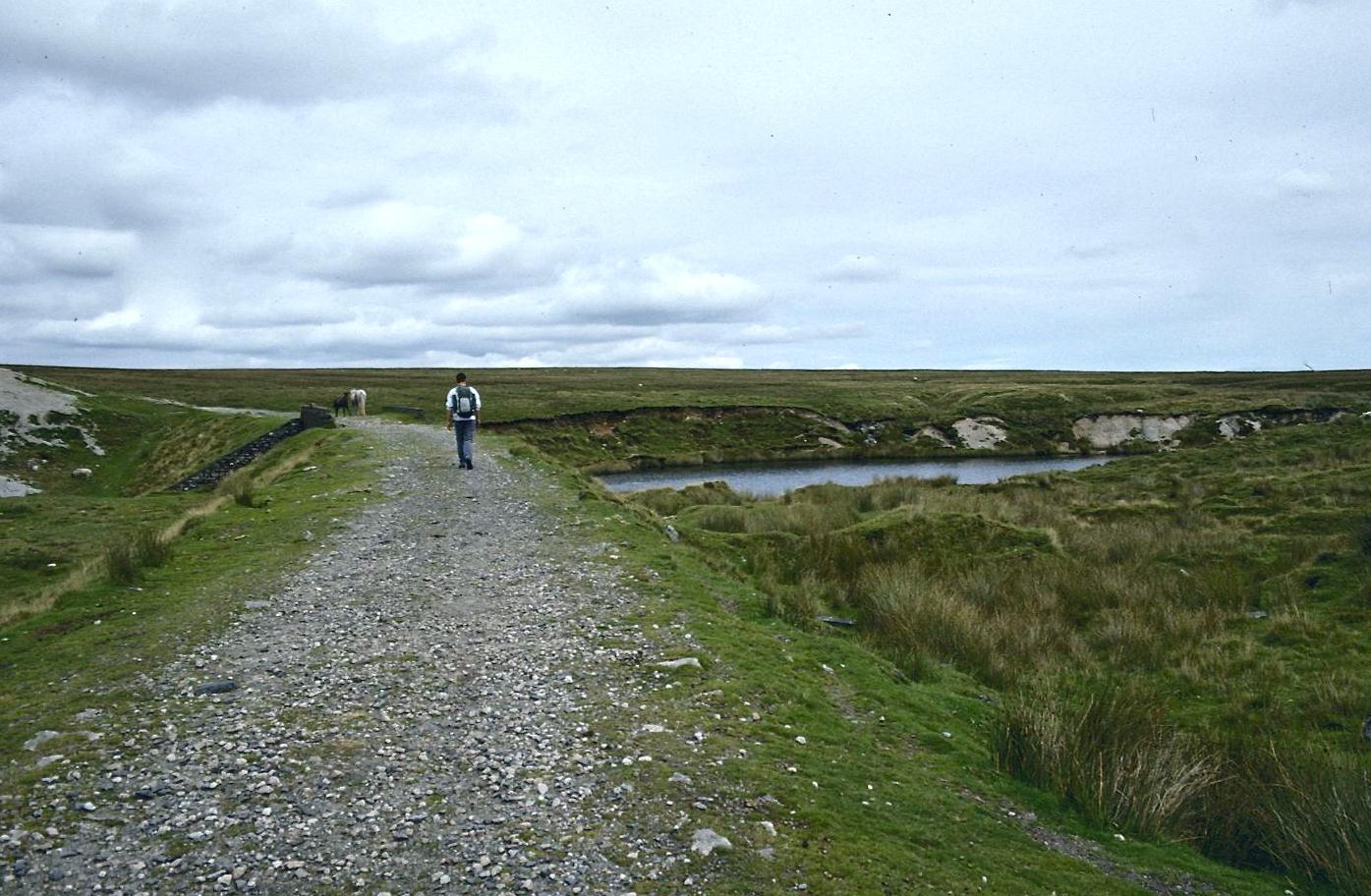
Old Clay Bridge
After lunch we continued north on the track, using a bridge over the flooded clay pit at Leftlake Mires. Wild horses were guarding the edge of this bridge but they scattered – never coming forward for a handout – as we got close. We had a second rest and water stop at about the halfway mark, just after passing some filter beds on our right. The skies were a bit darker now but there would be no problems with route finding even in moisture because of our excellent track. This part of the walk, however, was about to come to an end. We had one final hairpin bend as the roadbed swung to the east and shortly after passing the foundations of an old ruin we spotted a Two Moors Way sign directing us onto the open moorland as we joined forces for a mile or so with the ancient Abbot’s Way.
Unfortunately, although we knew where to leave our old track, it was not quite clear where we were to go next. There seemed to be two paths swinging away to the east and this confusion, we later learned, had undone many a TMW walker. We chose the higher, less muddy path but it took us a bit too far to the south, up to the foundations of some old mine workings adjacent to the trackway of the Zeal Tor Tramway. We knew where we were, both from the official guidebook and the OS map, but where we should be was not quite so clear. In the event we headed north, following the line of the tramway, before heading east over rippling grassland without benefit of any path. A hut on our right was a good landmark and we passed to the north of it to parallel the lovely Avon River down below us on the left.
August is a good month for walking in Britain because of the heather and the Avon valley was resplendent in the purple blooms of this acid-loving wild plant. We were looking for a way to descend to the river as we encountered a family (including a tiny toddler on her first outing). There weren’t any signs about, though evidence of a footpath was returning, and I followed instinct in choosing a gulley down to the river. This proved to be exactly right for we came out, as expected, a few hundred meters down stream from a clapper bridge meant to take us over the river. Ancient stone circles decorated the opposite side of the valley as Gavan decided to leap across the swift stream, using stones, while I circled back to use the clapper bridge in order to keep my feet dry.
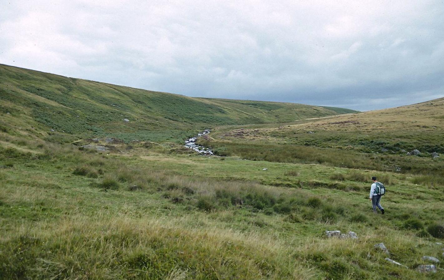
In the Avon Valley
He was waiting for me when I had made this circuit and we continued eastward next to the stream until we had reached some campers at Huntingdon Cross. Our next task, after fording Western Wella Brook, was to cross Hickaton Hill – but there was no path, no waymarkings, and very little on the horizon that could be used as a target. Gavan got out the compass and we headed in a northeasterly direction up a grassy channel, displacing several scurrying rabbits. This was a difficult climb because the footing was not easy: tussocky grass, hidden declivities, ditches that had to be leapt. At one point we mistook a heather covered circle of bushes for an enclosed hut group. As we neared the crest, however, our choices became more obvious. We were aiming for a junction of paths, including a crossing track and a path up Pupers Hill. We could now see, as one or two drops fell, other walkers on these paths and this helped us orient ourselves.
When we had reached the union of paths we could see a marvelous scene to our east, with green river valleys winding through hillsides checkered in hedgerow-edged fields and villages and farmsteads dotted throughout. But it wasn’t completely clear which track we were to take down a boulder strewn hillside in order to cross the River Mardle. There were many paths, some with more daytrippers strolling about, and I just followed my instincts in carving a line through the bracken, along sheep trods, and around trees down to the river. I was guided in my efforts by what I correctly guessed to be a tree covered lane to Scorriton on the opposite side of the valley. At last I found a grassy ride down to the bridge over the Mardle at Chalk Ford.
Gavan wanted to take a picture of me fording the river so this time I splashed across and he took the footbridge. We then paused for a rest and a snack, finishing off the apples from our lunch. We were now only two miles or so from our ultimate destination. We went through a gate and briefly uphill before beginning a long descent on a country lane to the village of Scorriton. It was just going six o’clock when we reached civilization and I proposed that we recharge our batteries for the final climb of the day by calling in at the local pub.
Unfortunately, however, we found no sign of life here. We sat down disconsolately on a bench outside the hostelry and even heard the family inside discuss what to have for tea, but it was soon evident that the pub didn’t open until 7:00 and so we had to go thirstily on. In fact, we disdained the recommended route up a green lane to Holne because we were already on the motor road. I suppose there is less traffic on the former but we didn’t have to squeeze ourselves up against the ripening bramble bushes too often as we completed a very steep ascent on tarmac. We were well out of breath by the time we reached the southern outskirts of town. As we passed a restaurant and the 14th Century church and drew level with the Church House Inn I recorded an arrival time of 6:30 on the little yellow underground ticket left over from my morning ride to Paddington. I kept it throughout the trip in my front pocket and carefully noted arrival and departure times which, like today’s, often indicated a quite expeditious pace (well, for us).
Holne was quite a charming village, with many half-timbered buildings. A teenager was just unpacking all his books from the family car as we checked in. The Church House Inn was already open but we passed up the bar in order to unpack in our own room, which had the luxury of private bath and toilet, on the first floor. Gavan always claimed the first bath on this outing; I was happy to relax and get my gear in order while he did this.
After my bath we went downstairs and had our first end-of-trail drinks. I used the local call box to speak to Dorothy; I was particularly eager to know how little Toby was doing, following minor surgery on his left foot the previous day. I had some mushroom soup and some rather unsuccessful plaice fillets. We never seemed to order dessert on this trip; perhaps we had enough sweets in our pack, including some Devon toffees which, like coals to Newcastle, I had brought with me from Sainsbury’s.
We had another drink or two and Gavan smoked the first of the cigars I had asked him to bring from America. Unfortunately I wasn’t in the mood for a smoke yet and he got out of sorts over my refusal. As usual we retired rather early but it wasn’t easy to get much rest. We were perched over the kitchen and the staff had Radio 4 on at such a volume that it was possible to hear the Book at Bedtime had we wanted to. Eventually I solved this problem by putting in my earplugs and some time around midnight the place finally grew quiet.
To continue with the next stage of our walk you need: