
April 22, 2005: Forest Row to Blackboys
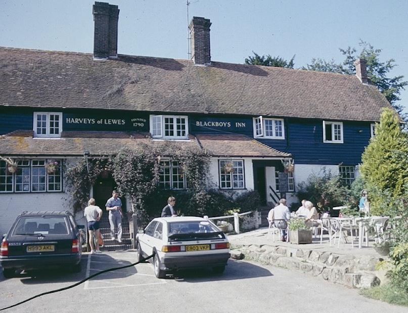
A welcome oasis at the end of a strenuous day – the Blackboys Inn
Ten days after reaching the half way point in our progress along the Vanguard Way the Lees and I set about to complete our fourth day on the route. In the interim I had been wrestling with two walking-related problems, booking accommodation for our June walk in Lakeland and purchasing the next Explorer map needed to assist us in our route finding here in the South – the elusive sheet 135. I had visited five book stores in search of the latter, having had no luck at a Books Etc., two Waterstones, Daunts Travel Books – even the rack at Stanfords was empty. Noticing some unloaded boxes in the latter emporium, however, I had persisted with a clerk who told me that 30 copies were on order but that he had one laminated edition in a drawer somewhere. It was with this precious and expensive object that I set out today.
Originally (and overoptimistically) I had planned to set out on a long day with the usual 9:00 tube entrance. But Tosh, already foreseeing a late return, suggested that we might just as well forego the privileges of Freedom Pass and Senior Rail Card and make an earlier start. So I left the house at 7:15, after taking out a protesting dog for a brief street run, and made my way by tube from Maida Vale to Baker Street and hence, via the Jubilee Line, to London Bridge.
Here I came up with still another plan for rail tickets, buying a regular single to East Grinstead and a return (using pass and card) from Uckfield. Harold followed this strategy and we just had time to buy snacks and coffee before boarding our 8:25 train. It was a lovely sunny morning with temperatures that would reach 60 (that is if you are still wedded to Fahrenheit).
On our southern journey I filled the Lees in on my successful attempts to secure map and accommodation and we gossiped contentedly while drinking our cappuccinos. I ate a small bag of peanuts – remembering that I do not do well hiking on an empty stomach. Everybody used the space age loos on this train (the conductor even pushed the button to open the door for me) and then we gathered our stuff at the end of the line, after a 50-minute journey, in East Grinstead. I knew there was a cab rank outside this station and so we were soon aboard, assuring the cab driver that our request for a trip to the Foresters Arms in Forest Row represented a desire for a starting point for a day’s walking, and not an early drinking opportunity.
We were able to begin our walk, therefore, at 9:30, about an hour and a half earlier than I had originally planned. What the consequences would have been had we really started so late – on a day that proved to be very strenuous and full of adventure – I cannot say. I was still wearing my old navy puffer vest, though I did take my scarf off before starting out. In my map case I had folded Saunders’ text and the relevant section of sheet 135, though I told the Lees that even after thorough study I couldn’t always link the text description with the map (where, supposedly, the Vanguard Way is marked in green diamonds) and that I hoped it would all be clear on the ground. I was often disappointed.
We turned east along the busy B2210, passing shops – including one that offered fish and chips and pet food. At a telephone kiosk we crossed the road and took a footpath that wound behind gardens and took us up to a suburban road heading south. At a post box in the wall we crossed our street and used a path to reach a road entrance to the Royal Ashdown Forest Golf Course, a sprawling complex full of the usual ambiguities for walkers – though there was an ornately carved brown wooden Vanguard Way sign pointing in the right direction – even though it seemed to offer a footpath where Saunders keeps us on a road. I followed the road.
We headed east around several bends, descending all the while. The instructions called for a rendezvous with two houses, Warren Heights and Fernroyd, but our pursuit of the latter caused us to veer off-route slightly for when we reached the bottom of our hill I couldn’t get things to compute as we turned south on another road and began to climb a hill in search of a third house, Shaleshurst. I stopped an elderly couple out with their dog to ask them if they knew its whereabouts and they did, telling us that all we had to do was reverse our progress and follow a path along a stream to our left. The chap actually tried to save us some time in reconnecting us with the VW by attempting to penetrate Saunders’ text in mid-flight, but this proved impossible and I preferred to make sure of my orientation by reaching Shaleshurst first. It was only two minutes away.
When we arrived, and I felt confident about my position again, I realized that, by accident, I had been on route after all, so we re-forded the stream, re-reached our uphill road again and, only a few yards after the spot where I had stopped the couple with the dog, we were able to make further progress by turning left – now with woods on our left and a fairway on our right. There were no VW waymarks at all and each landmark reached was the occasion for a sigh of relief – first a tee on our right, then the crossing of several more footpaths, then a tee on our left, then a march along a woodland track, then the crossing of a metaled track, then a descent to a second ford, then uphill on a rough track with the golf course on our right. We were now heading south, the dominant direction of this walk, but the incline was quite steep and I was getting warm. We left behind quite a few golfing parties – these people must have thought us mad.
A house with garage was our next sighting, another sign that we were on the right track. The golf course remained on our right for a long time, though we never saw another golfer, and, as we at last left its precincts for further adventures in Ashdown Forest, we did so by continuing on another steep uphill section (good views behind us) to reach a crossing track. Here we turned left and after 100 meters (or so it seemed) reached a turn off to a nearby road. We had the briefest of rests here as I took my vest off and stuffed it into my pack; with food (that I never touched) and all this extra clothing my bulging pack was much too heavy for a day trip. I told the Lees that in a little over an hour there had been 35 separate route-finding instructions in the guidebook.
We crossed the road and curved around two sides of a bowling green. Then it was along the edge of a cricket pitch and forward on paths and tracks through a delightful woodland – with open spaces and glades and wildflowers in the sunshine. A brief descent to a road at a farmstead at Newbridge put us briefly back in civilization. We were now meant to use the road to head south to a famous local road ford, one called the Splash. We found it but I missed an instruction to turn left on the road covered by these waters, and continued forward looking for a right-hand turn. This soon didn’t make any sense – as a right turn now would send us off at the wrong angle, and so I had another look at the text (“TL to cross ford”) and so we were able to correct our line.
Unfortunately we now had another very steep climb – past houses and a horse training ground and so on up our track. A girl on a horse came plodding up behind and soon passed us, four legs proving far better than two on such an incline. Tosh, as last time, was usually out in front today, with Harold bringing up the rear. She stopped when she reached a crossing track in the coconut-smelling gorse and when we joined her we all sat down and had some water.
Saunders talks about a five-ways junctions of tracks (I could count only four) but we seemed to be heading in the right direction as we followed tracks and paths toward the summit above us, the wooded enclave of Gill’s Lap Camp. Tosh found a bench here and sat down next to a trig point and we joined her for some magnificent views to the west. Just to prove my point about the disconnect between text and OS map, I noted that the latter doesn’t have the Vanguard Way climb to this point at all.
It was past noon now as we set off on a far more level route, using trackways to head south in an open country with nearby roads and many bridleways. I had mentioned to Tosh that at the next parking lot ice cream vans had been spotted in the past but the only commercial vehicle we encountered as we neared the B2026 was a Rentokill van. We crossed to the east side of the road and continued forward, still climbing slightly and passing more car parks (there were lots of people and their dogs strolling about) and at the last of these there was an ice cream van, though Tosh had only wanted a cup of coffee. We had just passed, at right angles, a section of the Weald Way that we had completed fifteen years earlier.
We passed around another bit of woodland, King’s Standing Clump, and started in a southeasterly direction along a spur that gradually lost elevation. I wasn’t at all certain that we were using the options outlined in Saunders, and once I called Tosh back as we searched for a half-right turn. I couldn’t be sure we were doing the right thing, though I could see across the valley a ridge with a road – which I believed to be our ultimate destination. So we climbed down (there was a stream here) and while the Lees rested I began another long uphill pull, passing some woods on the right, and at last reaching Old Bell House and the A26 at Poundgate. Here there was a VW marker at last.
When the Lees reached this spot we turned right in search of our noontime pub but something made me have a second look at the text – we were meant to be heading left on the A26, not right. No sooner had we turned around than the desired watering hole was staring down at us and a few minutes later we were at the Crow & Gate. I didn’t see any activity and this bothered me but the parking lot was hidden away on our left and there was a sign promising good British food all day long – so, reassured, we entered a very busy establishment for some refreshment. It was 1:22.
We found a table (unfortunately next to a room containing a large number of women and screaming babies) and ordered our drinks and food. I was drinking a Diet Coke but it had been consumed and a second one ordered before we noticed that our food order had gone missing. Tosh was into her second pint of bitter shandy before that lady had some cross words with the bar staff (“They’re doing your order now”) but another half hour passed and everyone else in the pub had been fed. “‘Good British food all day long’ means it takes all day long to get any,” I explained. Harold was growing very angry when, after an hour plus, his schnitzel, Tosh’s fish cakes and my fish and chips arrived, amid apologies. It seems that one of the chefs hadn’t shown up for work (doesn’t help explain why everyone else got fed); the staff offered to buy us free drinks and took one meal off the bill. The food seemed to pass muster, after all we were ravenous – though my fish had been armor-coated in batter last used in the Boer War. We paid up (even Tosh knew not to ask for coffee at this late juncture), used the loos, and prepared to leave. It was 3:05 and we hadn’t quite reached the half-way point in our thirteen mile walk.
This was, indeed, a walk of two halves, and – the Ashdown Forest section behind us – we now faced some six and half miles in agricultural surroundings, with lots of woodland about and many stiles. On the positive side the route forward was actually waymarked – most of the time.
We crossed the A26 at a telephone kiosk whose glass lay in little shards and crossed our first stile, passing some houses and threading our way along a hedgerow with many more stiles before turning left, downhill, to reach a wood. We used paths here to walk among the bluebells. After passing a cottage we approached the white eminence of Stroods House, where the landowners, protective of their privacy, had secured a diversion that took us quite pleasantly down to their pond, across their greensward, past their tennis court and so into fields again.
Again I wasn’t quite certain if we were following the intended route downhill but we were – as a VW marker soon confirmed. Before beginning our descent to a stream we encountered a sign (bearing the legend of the Country Landowner’s Society) welcoming “considerate walkers.” As the slippery sunken path was very sloppy I wondered if we couldn’t count on some help here from considerate landowners. At the bottom of the hill we crossed a footbridge where I was welcomed by a friendly pooch named Minnie. The Lees soon caught up and we used an access road to reach the hamlet of High Hurstwood.
We took a left to reach the interesting church here, then escaped via the first in a series of kissing gates that lead us by houses and out to a road. Here I discovered a VW waymark pointing left but I suspect that the original off-road route had been extinguished. It wasn’t too difficult to figure out how far to proceed along the road before our next turn off – which put us on a concrete track and lead us south to another road, where we turned left. A farmer was mailing something from the post box and a Tesco truck was bouncing along the rutted roadway as we reached Ironcastle (which must be the name of an adjacent house – all we needed to see was this name on a trashcan) where we turned right for more adventures with fields and stiles and footbridges as we continued south.
The late afternoon sunlight was delightful; it gave to the countryside a smoky appearance that we rarely see. We crossed the infant River Uck and passed through woodland that lead us to an underpass beneath the Uckfield-Crowborough line, one that we planned to use ourselves if we ever got to the end of this walk. There followed, however, another long uphill pull, with houses offering variety to the scene and, after our track became Redwood Lane, we reached the A272 at Pound Green.
We turned left here briefly, entered Limes Lane and soon encountered more stiles and fields. We were all getting quite weary and I had to stop for a few seconds every now and then when I felt a bit lightheaded – especially when I bent over or got up too quickly. I was counting down the paragraphs (nine) between our lunch spot and the conclusion and each did seem to take so long that Tosh (who had never been in her new boots this long before) was in despair. Nevertheless we reached the end of paragraph seven and after a brief stint on a road, began another cross-country section.
This lead down to a stream that we crossed and then followed for a while, leaving it behind to enter a farmyard that was a monument to rusting and abandoned machinery. The Lees agreed that such rural squalor would certainly not pass muster in Coon Rapids, Iowa. Things had been altered a bit since Saunders had written his description but we did find a VW sign directing us to climb an access road and so reach Pound Lane.
Here I announced that we were beginning the final paragraph – by turning right on the lane before deserting it to descend to the large millpond of the Tickerage Stream. This was a delightful site, a quintessentially English scene with country house and swans afloat. We were joined for 200 meters at the bottom by the Weald Way, parting company with it as we climbed a road and scrambled up a hillside (there seemed to be so much more up today than down) to continue through more fields and even through a large section of allotment gardens, where I had to guess where to make a left turn and the Lees were enchanted by the artichokes. At last we reached a road next to a village hall – was this the former Scout headquarters mentioned by Saunders? We turned south on this hard surface and reached a crossroads at Blackboys. Continuing ahead on School Lane we soon reached a familiar corner for on our right was the Blackboys Inn – which we had visited during our earlier walk on the Weald Way. It was 6:45 – one of our latest ever concluding times for a London-based day walk.
Harold remembered the place well – I couldn’t recall if I had even been inside since I knew we had been seated at one of the picnic tables with our dog Toby during our earlier visit. Now we all headed for the saloon bar of a very crowded establishment – where all the tables were reserved for diners lining up to decide whether to have the Crab Mornay or the Crab Salad. The Lees took positions on bar stools and I found a little bench. I had Dorothy’s mobile phone with me and with it I attempted to call one of the many cab numbers I had taken off the Internet. I got no signal and the bar lady said, “You’d be lucky” when we asked for some help in securing a taxi. The barman did loan me his phone and this time I reached Fairline Cabs in Uckfield, but the cabbie said that it would be forty-five minutes before he could be in Blackboys. I agreed to this and settled into my double Bells. Harold did too and Tosh had a double Jack Daniels.
At one point I went outside and this time I was able to call Dorothy – who was mightily puzzled that I was still in deepest East Sussex. On my way back I noticed that this pub (which seemed to be populated by the braying gentry out for a Friday night feed) had a sign with a baby on it and the caption “No Screamers.” The Lees freshened all of our glasses and we began to chill out after a very eventful day – maybe it was just as well that the cabbie had left us forty-five minutes drinking time.
He showed up at 7:45 and off we went. Hearing our mileage totals he suggested that he had driven over 200 miles this day and when I asked him how many fares that meant he counted them all out and reached fifteen. And you could tell that he still had plenty of clients to go. He pulled up at the Uckfield station just before 8:00 and we rushed onto a train that was parked at the end of the line. Fortunately this was the 8:04 and we were soon off, almost the only passengers in our carriage. The train made a lot of stops at places we knew well – Crowborough, Edenbridge Town, Hurst Green, Oxted, even East Croydon. As we neared London Bridge at 9:15 there was a magnificent display of fireworks on the Thames. “Maybe they finally found a buyer for the Millennium Dome,” I speculated.
Together we stiffly marched down to the Jubilee line, the Lees (as game as ever) deserting me at Green Park. I changed at Baker Street again – at this late hour there was no problem with finding a seat. It was 9:55 before I reached home at the end of a very tiring day. Then I had to walk the dog and even when I went to bed my mind provided a kaleidoscope of trail scenes spinning around for hours – until I took a pill. The next day I took two naps and walked stiffly about for a few days after that as well.
To continue with the next stage of our walk you need: