
August 6, 2005: Blackboys to Berwick Station
The church at Chiddingly
Only eight days after completing a stage on the London Outer Orbital Path the Lees and I agreed to use this 60th anniversary of Hiroshima (a day I remember well) to undertake our penultimate journey on the Vanguard Way.
We needed an early start and so I suggested a rendezvous at London Bridge at 7:45. I had no problems with the underground on this morning (and I could use my Freedom pass at this hour on a weekend) but the Lees had discovered that both the District and the Piccadilly lines they would normally have used were undergoing engineering works and they therefore arrived by taxi.
Harold and I stood in the ticket queue but there was only one window open for some time – and the line was growing ever longer behind us. When we at last reached an opening the clerk didn’t want to sell us our return tickets from Berwick, arguing that it would be cheaper to buy a return from our destination rather than from here – and insisting that there would be a ticket counter at the other end as well – I think he didn’t want to spend the time looking up the discounts we were entitled to – and so we just bought singles to Uckfield for £5.50 each.
The Lees went off to use the loos while I disappeared into an Upper Crust to buy a cappuccino and an egg mayonnaise sandwich. This I ate for my breakfast once we had boarded our Southern train (remembering to walk forward to the right carriages this time) and at 8:07 we were off. Tosh opened the Independent and shared highlights with us for the next hour or so. The Lees had been outraged that a Bush apologist had been allowed too much time to discuss the recent London bombings on Newsnight and had written a letter of complaint. We all used the space age loos (no water in the taps, however) and I attempted several times to rouse a taxi company in Uckfield on Dorothy’s mobile phone. At last I was successful and the chap promised me that a red Skoda would meet our train at 9:21.
Uckfield is the end of the line for our train service and for once there wasn’t a rush to be ready for departure. As we walked along the platform I could see our cab pulling into the station and so we were soon speeding toward Blackboys. Our cabbie said he had played golf yesterday and that his punishment was having to work on a Saturday morning now. In five minutes or so we were outside the Blackboys pub and after I had paid the driver I used one of the outdoor tables to organize my guidebook and another new OS map in the Explorer series (sheet 123: Eastbourne & Beachy Head). It was great to get under way so promptly – a 9: 30 departure at a site so distant from London was unusual.
Saunders had warned that there might be some rerouting in the section that began across the street from the pub so, after we had crossed the B2192 and climbed a stile, I paid close attention to the footpath signs and the OS map as we moved forward on a grassy path that turned sharply left downhill. As we neared a path junction adjacent to a road I spent a lot of time staring at my compass (in constant use today) before determining that the road in question was Hollow Lane and that we needed to follow it in a southeasterly direction.
Skies were quite cloudy, though the scene was bright enough, and there were extensive vistas of gentle rolling farmland at a number of points. At a turn in the road we turned off on a more southerly line along a grassy track and continued forward to the next paved road, Bushberry Lane. Here we turned left and continued on tarmac as far as the flowery Pear Tree Cottage – where a little jog to the left put us out into open country to walk along the right hand side of a field.
We reached another road and headed south, woods on our left. At a road junction we abandoned paved roads for a short time and turned half right into a bare field with an obvious path leading up to the corner of a woods. Here there was a spot for peeing and water drinking and I had warmed up enough to take off my maroon sweatshirt; I was wearing my red Old Navy t-shirt underneath.
We walked in a southeasterly direction again and soon reached another road – where we turned left for a short distance, abandoning its surface for progress through a number of fields and down to a stream crossing. Vanguard Way signs often helped in route-finding on this day (yellow, red and black styles all making an appearance) but often, when you really wanted one, there was no evidence at hand.
We now had a hill to climb, with a grassy track at first and then a wet and muddy one, dark under tree branches. At the top we reached another road and this time, dodging the occasional vehicle, we made a southerly progress past cottages and farm buildings, marching an easy kilometer before meeting a road junction at Scallow Bridge. There was a brief dogleg to the right here and then we continued in our dominant southerly direction (for today and the entire route) for a second kilometer.
At a second road junction we headed off, in posh surroundings, into woods on a faint path that soon improved as we caught distant glimpses of houses and their yards and emerged next to a wonderful cottage on a private drive. Here I had to refold my map – one of the disadvantages of the two and a half inch to the mile format is that you cover sections – at least on the map, not on the ground – more quickly than on the one inch to the mile plan. I was having a lot of trouble squeezing the map back into my plastic case but at last I succeeded. There had been a few changes in the surroundings hereabout and I was glad to encounter VW signs, but after a bit of woodland we had some difficulty making certain we were on the right southeasterly line.
At one point we were pressed right up against the grassy border of a caravan camp, the lumbering giants circled around a large green as though they were ready to resist an attack by the Comanches. We said hello to a few of the campers but they stared back at us as though we had come from outer space.
More on instinct than as the result of any signage I persisted on my line as we crossed several more fields, with rabbits scurrying as we advanced. Eventually we reached a track, which I took to be the one mentioned in Saunders, and here we turned left to reach a road. It swept through a little settlement, first in a southerly direction then in an easterly one. Saunders refers to the place (two large farms and some cottages) as a hamlet, but it has no name on the OS map.
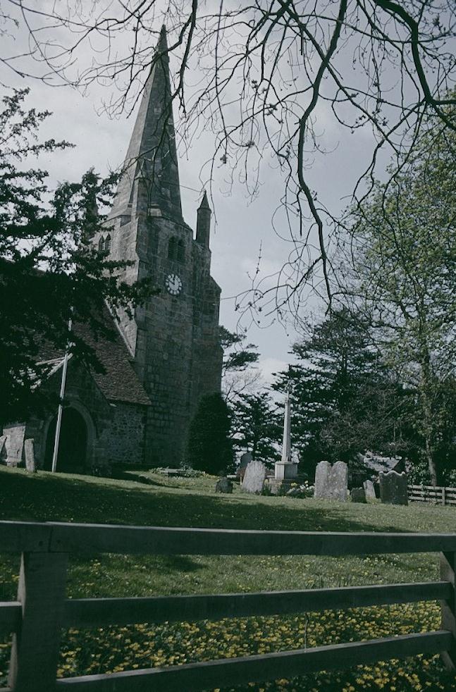
A finger post directed us up to a field and here we caught our first glimpse of the spire of the church at Chiddingly, our noontime destination. Indeed behind it, still at some distance, you could see the dramatic rise of the South Downs themselves.
We were following a lady out exercising her dogs as we drew level with a telegraph pole and continued forward through three fields. When we reached a road we turned right for only a short distance before climbing into another set of fields. Many of the latter were ripe with stalks and a few were already being harvested – but of course we city folk had forgotten our lessons on the differences between wheat, oats and barley. “Let’s just call them amber waves of grain,” I concluded.
Sometimes we were on the right edge of fields, sometimes on the left. A horse trough was exactly where Saunders said it would be and that was a useful waymark too. After several more fields we entered a grassy path and at its end we stood facing the church across the street. We had reached Chiddingly and just to our right was the famous Six Bells. We had made such good time that, after six miles, it was only about 12:20.
The roadway we used to reach the pub is also shared by the Weald Way (the only time on this day that the two routes coincided) and so we had been here once before. I remembered that the bar staff had been very kind to Toby, bringing him a bowl of water, as he cooled off on the cold brick floor, and that the pub itself was a museum of ancient photos and advertising signs. None of this had changed.
We found a little table next to the bar counter and ordered our food. Harold had chili (which he pronounced better than the chili in Coon Rapids), I had lasagna and salad and Tosh had a jacket potato stuffed with brie. “This is the first time I’ve had a jacket potato and it’s really good,” she said when the food arrived – quite speedily for once. “You’ve had jacket potatoes many times,” I argued, “You had one in Canterbury.” “Did I like it?” she asked. “Not so much – since you poured sugar on it instead of salt.”
The bar scene was presided over by the attractive Emma, who kept everything turning over (“Wait your turn!”) as the bar soon filled up with locals and strangers who needed driving directions. She complained that it had been even busier the night before and that customers, taking pity on her, had bought her a lot of drinks. It had been very hot and she had gulped these down – the result being that she was quite shaky by the end of her shift.
We left at about 1:30, half of our walk over, and returned to the church where our route passed through the churchyard and into the village cricket pitch. When we neared our exit a lad asked us if we could help push his friend into the field – since he had gotten his car stalled on the entrance incline and the irate gentleman just behind them didn’t want to damage his bumper by giving a shove with his car. So we all put our shoulders to the back of this vehicle (it was fortunately a small car) and with a mighty heave managed to propel the Corsa onto the pitch.
We climbed a stile and headed across a field in a southwesterly direction. There was a chill wind and I paused to put my sweatshirt back on. At the far end we found a stile and continued forward to a stile and plank bridge that lead into a thin strip of woodland and, having cleared this, we turned south. Tosh was out in front during this section and I told her to look for a pond as she marched southwestwards but our thin trod (against the side of the woods and then along a hedgerow) seemed to me to be shifting directions and my compass confirmed the problem – we were heading due west. After five minutes or so I called a halt and ordered a retreat. We had to retrace our steps almost back to our original passage through the woodland strip before I spotted the pond in the woods. Directions suddenly seemed to make more sense – for we could now pass to the left of the pond, across a footbridge and over a stile into a field. Here nothing made sense.
Saunders writes, “Turn half right across field, ignoring more obvious field edge path to walk uphill towards horizon roughly R of centre between two woods.” This was not possible on this occasion because the hillside in question was planted in densely packed rows of burgeoning corn. There was no evidence of any way through and the stalks were too tightly packed to attempt one of those slashing attacks (i.e., the walker gets slashed) along the rows. We were faced with a serious rural crime – after all, the right of way for our route is even memorialized on the OS map – but there was nothing to do but find an alternative way forward.
At first it seemed that we could walk around the field on the left-hand margin, where a path existed, but when this petered out I began to have my doubts about this strategy – for there was no way of telling what obstacles might lie ahead if we persisted in staying with the corn. There was the beginning of a well-established footpath into the woods on our left and I decided that this must at least lead us back to civilization, that is to a road, and so we took it. The only problem was that we wanted to be heading southwest here and this path was taking us due east.
Soon we could see the buildings of a small hamlet and we emerged onto a road where there was a school and a telephone call box; beyond these there was a road junction with signs pointing to a variety of destinations and I took my map out of my case and, with the help of my compass, attempted to figure out just exactly where we were. We were in a hamlet evidently called Muddles Green, an outrider of Chiddingly to the north and, by following a road to the southwest, we could reach Golden Cross – within striking distance of the Vanguard Way. So this is what we did, paralleling our lost route on tarmac but at least heading in the right direction. Tosh put forward a claim for an additional mile to be added to our day’s total and I acquiesced readily. Today we would walk thirteen, not twelve miles.
There wasn’t too much traffic on our country lane and I was happy to encounter landmarks that confirmed our position. I told the others that there was one happy dividend to be derived from this diversion – there was a pub in Golden Cross! And there it stood – the Golden Cross Inn – across the whizzing traffic of the A22. We found a traffic island we could use to cross this highway and entered the pub, welcomed by a sign reminding everyone that its toilets were for customers only. Perhaps there was also a sign like this at the petrol station across the road – for there was a caravan camp just to the south.
Harold and I ordered Diet Cokes while Tosh had half a pint and a cup of coffee. This was actually a painful process because the barman seemed to have great difficulty in hearing anything that was said to him – and, under any circumstances – he was immersed in the crossword puzzle in the day’s newspaper. We were in the pub for half an hour or so, used the loos legally, and left to resume our search for the Vanguard Way. I decided not to march along the A22 for this reunion (even though this would have permitted a visit to the Mohair Centre), electing the much more straightforward march along another road that lead us in a southwesterly direction from the back of the pub. In a few minutes the Vanguard Way joined us from the right.
Soon we left the road for a series of fields, often with rather derelict stiles and not much evidence of footpath, as we worked our way south. On our right a heavily laden lady was emerging from a visit to a fishing hole and when Tosh asked her how she had got on, the woman replied, “Nothing today.” We passed through a little car park and reached another road. A dogleg to the left inaugurated a similar stretch of field walking but when we reached the next road we were invited to turn right for a very long stretch of road walking.
The sun was making a stronger appearance in the mid-afternoon skies and there was very little traffic on the paved lane. As we neared Mount Pleasant Farm, however, there were increased signs of activity, human and ovine. First there were cyclists (one mother and daughter came up silently behind us but the mom offered a pleasant greeting in order not to startle us). Near the farm entrance kids were standing in the middle of the road and I soon discovered why – a large flock of sheep, pursued on foot by the farmer himself, was heading at speed straight for us. They somehow knew enough to turn into the farmyard, however, and when the panting farmer followed them he turned to the assembled crowd and said, “You all wanted a bit of a rest, didn’t you?”
Our roadway ended at a cottage called Selmeston Croft but a track continued in the same southwesterly direction. I had been looking at my watch and I had concluded that if we didn’t dawdle there was a good chance that we could make the 4:47 train from Berwick. Since there is only one train an hour on this line it was obvious that such an arrival would be very useful and Tosh was all for having a go. Unfortunately, the track was deeply rutted and waterlogged and there were pools of stagnant water to dodge as we tried to find dry ground on either side. I got far ahead during this stretch, trying to lead by example, but I was only successful some of the time and my boots were soon caked in mud.
We emerged at last in the bright sunlight on another road and this carried us forward, still moving in the same direction, up to a road junction. Here we turned right briefly and then climbed a stile into a bare field. We followed the field edge up to a stile but at this point I saw before us a sight that wrecked all our plans! The pathway should have lead directly up the hillside below Mays Farm but we could see no way forward at all – the entire hillside was choked in corn.
Dispirited, we reached the foot of this vegetation and, finding no way forward, again began a flanking tactic, edging our way around the left side of the green expanse, climbing in and out of field corners and eventually reaching the top – where a Vanguard Way sign meant that we had again rejoined the original route.
It was a little hard to figure out where we were in the guidebook instructions but we headed downhill on a well-marked footpath, encouraged by a Vanguard Way sign. I still thought we had a chance to make the 4:47 train and so we ploughed on, soon entering the well-landscaped grounds of Ludlay Farm. Saunders speaks of a planned diversion that would avoid a stretch of walking through the gardens of this establishment but signs were ambiguous and we wandered around a good deal, backtracking in places, until I was satisfied that we could use the access lane to reach the next road.
Here we turned south, the sight of the railway tower and the cross bars of the Berwick Station already in view. We had about five minutes to go and I pushed on at a great clip against the traffic, ignoring the calls of the Lees, who had discovered pavement on the east side of the road. It was therefore a great disappointment when, only seconds from the crossing, the lights began to flash and the bars descended and we were trapped on the wrong side of the line! Had we wanted to go to Eastbourne we would have been okay but here there was no bridge over the line and so we had to watch in despair as our train to Lewes pulled in on the other platform and soon departed without us.
After the bars were raised we walked over to the deserted spot and I reread the schedules. These confirmed that we would have to wait for the 5:47. There were also signs warning of heavy fines for traveling without a ticket and so, since there was obviously no ticket office here, we spent a lot of time wheedling three tickets out of a machine. Even though we experimented with price categories the cheapest we could get one for was £12.30. (Why £5.50 down and £12.30 back?) The Lees used up all of their cash in this fashion and we all ended up with pockets full of pound coins.
Across the street was the Berwick Inn and we now entered its friendly precincts to drown our sorrows. Tosh said she would have to use her credit card but the publican said she could even get cash back on her purchase – and so she did. She ordered us all double whiskeys but before I could drink mine I saw something in the back yard that commanded my attention – a young woman was playing with an Old English Sheep Dog puppy and I had to go outside a give him a cuddle. Eight month-old Ollie reminded me strongly of my own Ozzie at the same age, the same black body and the same fluffy white head. Ollie belonged to the pub owners and so he was soon allowed inside to be cuddled by everyone. Then we finished our drinks and headed across the street to take up positions on our unmanned platform. Behind us there were marvelous views of the South Downs.
We had plenty of time to apportion proper blame for missing the earlier train – i.e. to excoriate the farmers who had obscured the public right of way with their fields of corn. We had only a short ride to Lewes and here we had to wait about twenty minutes for the 6:18 to London Victoria. The Lees said they planned to have a nap but no one dozed off – indeed Tosh had her sixth cup of coffee from a girl just arrived with a refreshment cart. I got a decent signal on the mobile phone as we neared Gatwick Airport and called Dorothy. We reached Victoria on time, 7:29.
The Lees had been spending some time trying to figure out how to get home. They convinced themselves that the track work would not affect westbound traffic on the District and Piccadilly Lines and so we said goodbye as I hived off to take the Victoria Line to Oxford Circus. But as I was heading for the Bakerloo Line here I encountered my friends again. They were wrong about the District and Piccadilly Lines and were now seeking a far less convenient transfer to the Central Line.
As I was walking home along Grantully a few minutes later I had an odd encounter. Tosh had been in contact recently with one of the veterans of our very first walk with students, three days on the Cumbria Way during Alternatives Week in 1984. Tara McEldowney was heading for London and Tosh was going to ask her along on one of our walks. As I passed Leith Mansions, however, a young man just parking his car, got out of the driver’s seat and said, “Mr. Linick?” It was Marty Cornelius, another veteran of the very same walk. He and his wife Danielle, also a former student, own a duplex here and they had just returned from the States to refurbish it, prior to rental. Danielle soon emerged and so did Marty’s sister Stephanie and her husband. Marty said how much he would like to go on a walk with me. I gave him my phone number and headed for home, arriving while it was still light at about 8:10.
The next day I started to feel a bit unwell, with dizzy spells, headache and some problems in walking a straight line. What role dehydration had played in this (I remember twice refusing liquid offered me by the Lees), what effects the hour-long sprint had occasioned, what role too little sleep had played – there was no way of telling. But I was concerned with this outcome, hoping that it would not interfere with the scheduling of our next expedition – with now only one day needed to complete the Vanguard Way.
To continue with the next stage of our walk you need: