
June 16, 2005: Great Ormside to Shap
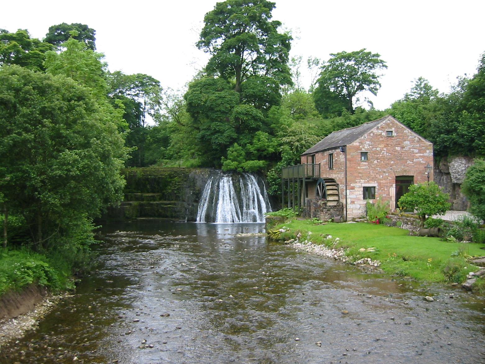
Rutter Force
Skies were still grey when I looked out of my window early on the morning of this June Thursday. Slowly I made my preparations and at 8:30 I went downstairs to see if my walking companions had emerged. Tosh and Margie had already done reconnaissance in the market square – indeed Tosh was absentmindedly reading her paper in the lounge of the Tufton Arms while the rest of us were waiting for her in the dining room.
Breakfast on this trip was almost always a spartan affair by local standards – the others would have poached eggs on toast and I would have mine scrambled. While these were being prepared I would drink a little orange juice and eat a bowl of Alpen; the women filled their bowls with stewed fruit. When Tosh piled the prunes on I said, “I’m not walking behind her today.”
We had been promised a ride at 9:30 so this gave me time to do a little lunch shopping and to enter a news agent where I could buy some labels for our backpacks: once again we would have these cumbersome objects sent forward for us, not by taxis, as I had long assumed, but by a new carrier, Brigantes. I had tried to see if Sherpa, our old carrier, could undertake this project but they don’t do the Westmorland Way and weren’t interested in those sections of our route that parallel the Coast-to-Coast Path – because they only move bags west to east and we were heading in the opposite direction. As late as forty-eight hours before our departure I was still searching the Internet and that is how I found Brigantes – who did carry bags along the WMW.
My conversation with J.M. Schofield had been an interesting one. After he had taken down our details I asked him if he were really stationed in Kirkby Malham – for I had stopped for a pint here on my very first day on a British footpath, thirty-one years earlier, while walking on my first Pennine Way expedition. When Mr. Schofield confirmed that he was just a matter of yards away from the PW, I asked a further question – “Didn’t Bill Bryson used to live in Kirkby Malham?” “He was my next door neighbor,” Mr. Schofield replied. I said I had read that the Bryson family had returned to the UK after some time in the States. “They’re in Norfolk now, my daughter talked to them last week,” was the reply. In fact, Mr. Schofield’s suggestion that we could just leave our money in an envelope for his carrier after we had reached Shap was made redundant by the arrival of the Appleby crew itself, a couple who were on their way to do some climbing in the Lakes, with Shap on their way. We gave them a check for the services of the company (Tosh serving as trip treasurer again) and sat down to wait for our own ride.
I had been under the impression that we were waiting for the proprietor’s mother, who was at the hairdressers, but our host, Nigel, was just waiting for her car, and he himself soon had us moving along the byways at last. He would take no money for this service (Tosh had left a generous tip for the staff) and within five minutes we were standing on the roadway in Great Ormside, ready to begin a very long day indeed.
The first mile or so was a recapitulation of the roadway that Nigel had just carried us over, though now we were heading southwest over several easily ascended hills in farming country – under gray skies. It was a pleasant enough beginning, with lots of wildflowers and cottages lining the road. The former included the purple blooms of a form of wild geranium, one of my favorites. At the crossroads with the Kirkby Stephen-Appleby Road they were shearing sheep. Up the hill ahead of us was our next target, an isolated house where we would climb a stile and leave the tarmac behind.
There wasn’t much evidence of pedestrian use in the field to which we were admitted, but I headed west in wet grass – that managed to soak my socks. Behind me worse was to come, for Tosh, crossing a boggy patch, had sunk to her thighs with both legs. This was explained to me when the Lees caught up; now the women stayed behind for some privacy while Harold and I climbed over a wall and onto another paved lane, one that was bordered on its western side by a pine plantation.
The girls caught up as we reached a turnoff marked Rutter Falls. I suggested that Harold ought to stand in front of an additional sign promising refreshments nearby but, even though there were customers at picnic tables when we reached this attraction, Tosh surprised me by not asking for a coffee delay and we were able to use a footbridge over Asby Beck, with an attractive waterfall and mill wheel in the background. Light wasn’t great but I was able to take a number of pictures this morning.
As soon as we had passed the outbuildings we entered a gate and climbed up a steep path to the top of the falls. Our way forward followed field paths along the bank of the stream until we reached a farm bridge. Even though there were no gates to negotiate at either end – as Hannon had promised, I put us on the opposite side and began a short climb up to a line of trees, turning right here and reaching a fence. I was using my compass at every point where there might be ambiguity today, and here I noted that we were required to use a second gate to pass next to a small wood and out to a road where we could resume our fast trod toward Great Asby.
An ancient chapel was our first landmark on this road and here we paused to put on our rain jackets, for the occasional dot of moisture was now turning into a real mist. Walking was pleasant enough, however, and we made easy progress up to a crossroads where we were warned not to damage the indigenous red squirrel population; a little later this injunction was translated as “No Dead Reds!” In fact we saw no squirrels of any color (just lots of rabbits) and, with the sun making an attempt to join the light rain, we arrived at the village of Great Asby soon thereafter. We passed the church and looked up the hill at the Three Greyhounds but it was only 11:40 and we still had at least ten miles to go. Had our train not come to a grinding halt yesterday we would have walked up to this point last night, perhaps even having our evening meal here as well (this under the bland assumption, however, that taxis were easily obtainable in this part of the world). None of this had transpired and the best we could hope for now was that the pub in Crosby Ravensworth might still be open after another five miles.
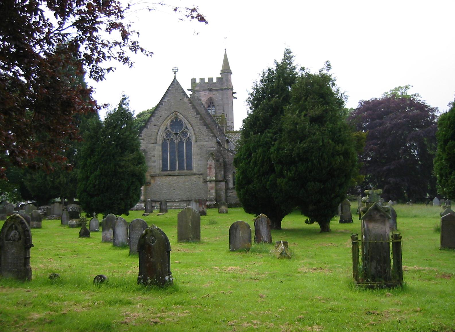
The church in Crosby Ravensworth
We sat down in the bus shelter and added our rain pants to our walking ensembles. Then we continued walking through the village, turning off after crossing Dale Beck and ascending on a track past a farmstead and out into open country. There was a considerable climb now – though the walking surface was still good as far as the entrance to Halligill Farm. Here we entered open moorland again and route finding became more difficult. A thin trod lead in the direction of a forested combe, which I took to be that of Halligill Wood. There was a stream to be crossed here and a steep climb up to a stone wall, but the view ahead, obscured by mist, wasn’t that easy to penetrate. I believe that some footpath rerouting had taken place since the republication of Hannon’s book in 1986 but by using his maps I was able to fabricate a plausible route down the hill to Greythorne Hall. Tosh wanted to have a snack in the yard of this establishment but I always feel uncomfortable just taking over someone’s private space like this – and she had to eat part of her lunch on foot.
We followed the farm’s access route along Scale Beck, emerging at an open space where we were invited to climb steeply uphill onto Bank Moor, with no path or prominent landmark as guidance. Margie was out in front here and I would urge her to aim for this or that sheep sitting in the grass, but in the event our breathless arrival at the open road of the B6260 was a bit too far to the south. Hannon does suggest that our next turn off is at the highest spot on this road, so here was a clue to turn right and head north on tarmac.
We then turned in a northwesterly direction on a faint bridle track, which was just a slightly paler color of grass than the rest of the moor top. It was mostly level and delightful to follow and we continued to make good time toward Bank Head Farm. An access track was picked up here for the long descent to Crosby Ravensworth, with sun and mist continuing to battle it out.
When we neared the bottom and crossed Lyvennet Beck (whose source we had visited on the Shap to Orton section of the Coast-to-Coast Path) Tosh paused to ask for some directions to the pub. Her advisors were not very sanguine about the pub being open, but I persevered up a side road and drew opposite the Butcher’s Arms at 2:30. We had made it a half an hour before closing time, according to my Internet source, but these days, it now transpired, the pub opened only in the evenings! We were bitterly disappointed. Once again we took refuge in the town bus shelter – this time opening our lunch sacks for a late repast. We had covered nine miles.
Our route next followed the Shap road, a steep climb on tarmac past the Haiberwain farmsteads, with trees sheltering us from the elements. When the road made a sharp turn to the north, however, we were ejected onto shelterless moorland again. We never encountered a stone circle on the brow of this hill but instead plunged downward into a walled lane that emerged onto the Oddendale-Shap road. The sun was at its strongest here (though it was still drizzling too) and the limestone pavements on our next ascent were glistening on the hillside.
We were entering the confines of the huge Hardendale Quarry, where trucks were at work on our left. Instructions were somewhat vague here – perhaps someone had moved some of the quarry debris that was supposed to serve as a landmark. At any rate what advice was available proved to be almost useless for just as we reached the heights the mist intensified and the rain pelted our faces and the way forward was unclear. There were wire fences everywhere and we thrashed about in several directions looking for an escape.
I was quite frustrated – but my companions were in good humor at least. I did find a trackway made of crushed rock and eventually I decided to follow it uphill and around a left hand bend, hoping that I would at last encounter another unenclosed road ahead. No sooner had we set off then the weather improved and visibility with it. At the top I could see several roads (always an encouraging sign) including one directly below us – which I now headed for over the grass. The odd thing was that some of this landscape, like the building on a road below us, seemed familiar to me – and so it should have been. By straying just a bit too far to the south we had emerged at The Nab, a farmstead we had passed several years earlier heading in the opposite direction on our Coast-to-Coast walk to Orton.
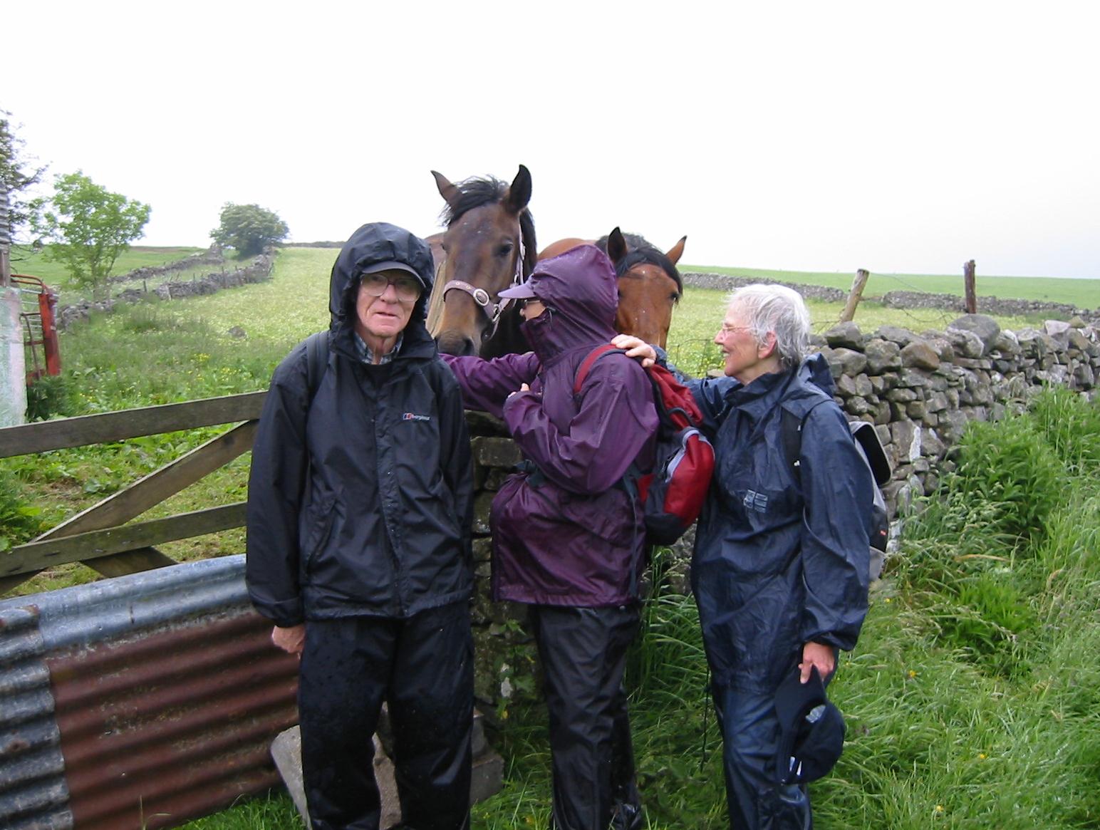
Harold, Marge and Tosh pause to greet some horses on the descent to Shap.
Rather than hunt for a continuation of the WMW itself I decided to rely on my memory in order to use the C-to-C route, even though I had no guidebook with me, in order to drop down the hill toward the M6 motorway. At the bridge over this motorized madness the WMW did indeed join us from above and we made our way over wet fields, with interested horses putting their noses over their fences, as we pressed on toward Shap. It was getting late and, after a tip from a local resident, we now had to trek to the southern edge of this ribbon village along the pavements of the A6 in order to reach the Greyhound Hotel at last. This additional mileage and the wandering about on Hardendale Nab caused me to modify the day’s total – we had walked fifteen miles and, since it was now 6:45, it had taken us nine hours to do it.
The Greyhound was a lively spot with a large number of Coast -to-Coast walkers, and their leader, in residence. Because of this kind of competition I had experienced considerable difficulty in obtaining accommodation in Shap and elsewhere, and, with the Lees’ agreement, I had booked the last two rooms in this establishment, two twin-bedded rooms. This meant that Margie would share quarters with Tosh and Harold with me. Our hostess showed us to our quarters and, just as importantly, to the drying room where we could lay out our wet clothes and deposit our newspaper stuffed boots. My green sweatshirt was particularly sodden. Fortunately our packs were waiting for us.
Each of us had a shower and at 8:00 we met in the bar for drinks. I had a well-deserved pint and started a second one when our dinner orders seemed to take forever and there was nothing to assuage our hunger but Nobby’s Nuts. At last, when we were comatose with fatigue, our food arrived (I had another fillet). We were all quite tired, though not dispirited, and I had promised us a shorter day on the morrow. By 10:00 or so we were all in bed after a very strenuous but rewarding outing.
To continue with the next stage of our walk you need: