
June 18, 2005: Askham to Patterdale
On Arthur’s Pike
We had reached the midpoint in our trip for this summer and this meant that we were about to encounter the full glories of the Lake District (and all the challenges accompanying such a terrain). We met at breakfast – where I had to make another choice of sandwich filler – the staff having run out of tuna fish. (A phone call to the Howtown Hotel had not been very promising, since they wanted me to book a lunch table for 1:00 and there was no way I could guarantee such an arrival time).
Outside it was rather gray and I kept searching the heavens for any sign of the weather’s intentions, for our progress today, even our choice of route, depended on this factor. Leaving our bags behind us, we made a visit to the doomed Askham Stores for some additional snacks – they had two packages of cheese and onion crisps left. Then, at 9:30, we turned our backs on the Queen’s Head, rising up along a second green – with a magnificent tree in its middle – and passing all the other cottages of this attractive village.
Our route soon exhausted the tarmac but there was an easy track to replace this as we continued to head uphill in a west-by-southwesterly fashion. Behind us we could now see Lowther Castle nestled in its trees and on our left a forestry plantation accompanied us for quite a distance. I was concentrating on our position with extreme care, following it not only in Hannon’s book but also on the old Northeast Sheet of the two-and-a-half inch to the mile OS Lakes series, because, after passing through some gates and obtaining a hilltop view of Ullswater below us, I intended to abandon Hannon’s book – at least for a mile.
Officially, the Westmorland Way makes its way over Heughscar Hill and Scar and then, crossing the Roman Way, descends for the night to Pooley Bridge. Since we had twice visited Pooley Bridge, walked the Roman Way, and climbed back to the moorland of Moor Divock (not once but twice), I suggested that we could now forgo another visit to these parts and eliminate enough mileage in the process to make the Askham to Patterdale stretch a manageable one. I now had to figure out which of the many tracks (crossing the moorland from north-east to south-west) would take us to a resumption of the Westmorland Way at the Cockpit Stone Circle – only a mile or so in front of us. Already I could see the path to Howtown at the northern foot of the High Street Range – and so off we went.
It wasn’t long before we reached a junction with the track ascending from Pooley Bridge. I told the others that I rarely improvise on our walks but that now we were witnessing my third attempt to make sense out of this one piece of obscure moorland – the first coming twenty years ago when I fashioned a low level crossing from Pooley Bridge to Bampton Grange, and the second, a few years later, when I floundered around searching out the Roman Way path up to the High Street ridge top, and now today, when I was inventing my own passage between two sections of Hannon’s route.
I think I was just slightly too far to the south here for when we reached the Howtown path we had to turn right for a short distance before reaching the stone circle. Off in the distance we could see riders from the pony trekking center at Pooley Bridge and ahead of us a number of walkers were taking up their positions. We now had another decision to make.
Hannon disdains the low level route to Howtown – except when low cloud obscures the higher elevations – and takes his followers steeply up to two adjacent summits (Arthur’s Pike and Bonscale Pike) with excellent views of Ullswater below. This will explain why I was so preoccupied with the weather today. Indeed mist did obscure a number of distant summits and I would have been happy to accept the safer and shorter alternative but as we neared the foot of our ascent (again missing the exact point where the Roman Way takes off), the skies began to brighten and visibility seemed to improve considerably. Moreover Tosh was eager to conquer some real Lakeland summits and, though Harold was obviously not too keen on the project, she swept away all objections and so we crossed Aik Beck, found our track, and began our climb.
I must say that I seemed to be in pretty good shape for this trip and I often lead the way forward, unusual for me when we are going uphill. The guidebook instructions mentioned a number of strategic cairns (still pronounced “carns” by Tosh), and this helped us plot our progress, but there were a number of false turnoffs – out to viewpoint crags or back down the hillside to the Howtown path. I paid special attention to the latter, since, if route-finding foundered, we could always retrace our steps.
We also had the good example of other walkers who were making this climb too and after an exhilarating ascent, with marvelous views down to the lake and north to many other Lakeland sites, we reached the summit of Arthur’s Pike (elevation 1747 feet) around noon. There was a brief rest here but I was already anxious to press forward to the second summit. This required a descent to a sheepfold on Swarthbeck Gill and another breathless climb to the cairn atop Bonscale Pike (elevation 1718 feet). I was well out in front on this stretch too – I told the others that they were lucky I was wearing my new Old Navy red t-shirt – which made it easy for me to be seen at great distances.
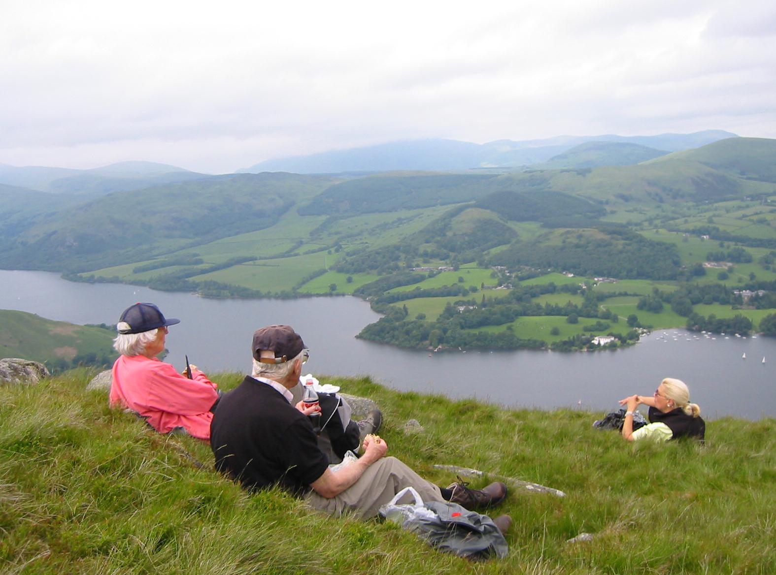
It was 1:00 and, with Ullswater (and a corner of Howtown) far below us, we sat down to eat our lunches. I had my ham sandwich, ate some crisps and drank some Diet Coke from a screw top bottle. There were two other walkers, also having lunch, off to our right but, now that I could have used some human targets to base my movements on, the route ahead was empty and obscure.
Hannon suggests that you need to travel south on a mostly level path (up and down I would say), resisting the temptation to begin a descent to the right until a dry grassy gully appears ahead. I didn’t find this altogether helpful – everything is grass up here – and I wasn’t at all certain that I had picked up the right gully to begin my descent. Nevertheless I worked my way into a rocky chute and began to look out for any of the footpaths mentioned in Hannon or charted on the OS map. The curious thing was that I could see, far below, the end of the path we needed to use to reach the intake wall at Mellguards, so I knew that I wasn’t lost. The sun was now shining brightly upon us as we began a very steep descent indeed. I congratulated myself on the deep knee bend regimen I had adopted in the weeks leading up to this trip; my legs would have to survive quite a challenge.
I left the others behind while I followed a transverse path back to the north. This indeed seemed to be well situated above a steep grassy slit in the bracken and I gave a toot on my whistle, a sign that the others could now follow me. Nobody did, and I had to go back to fetch them. There followed an excruciating mile of steep descent, one that served as a severe strain on toes and ankles. It never seemed to come to an end, indeed we were still snaking down at an acute angle, the last through a bit of bog, until we had run out of hillside at the Mellguards wall. By now our knees were like jelly.
Here we turned left, passed through the farmstead and, disdaining a quick return to the moors, used its access road to reach the lane down to Howtown. It was 2:30 and I pushed through a huge throng of walkers and tourists as I made my way into the hotel garden and into its tiny pub. There was room for us to sit down (in a humid heap) and Tosh spent much of the restful forty minutes or so plotting how to escape another six miles of walking still ahead. The Lees even got a copy of the ferry schedule from the barmaid but, in the event, at about 3:30. they agreed to join me in the second half of the day’s journey. Harold and I now unzipped the legs on our walking trousers (I walked in shorts for the rest of the trip) and we set off.
Walks along lakes can offer some easy miles and so it was along Wastwater, Buttermere and Derwentwater. But the walk from Howtown to Patterdale along Ullswater is a scramble, full of ups and downs, often on surfaces that can punish tired feet.
First we retraced our steps to Mellguards and crossed a stile, a footbridge, and the Howtown road again, to climb up against a wall that curved around and sent us forward at the foot of the Steel Knotts ridge up the valley of The Combs. Much of this was uphill again but, after reaching a crest, we descended a short distance to reach the church at Martindale Hause. A man asked Tosh for directions here and she said he would have to wait for the man with the map to arrive. I had to break the news to him that the height he sought was the steep one behind him.
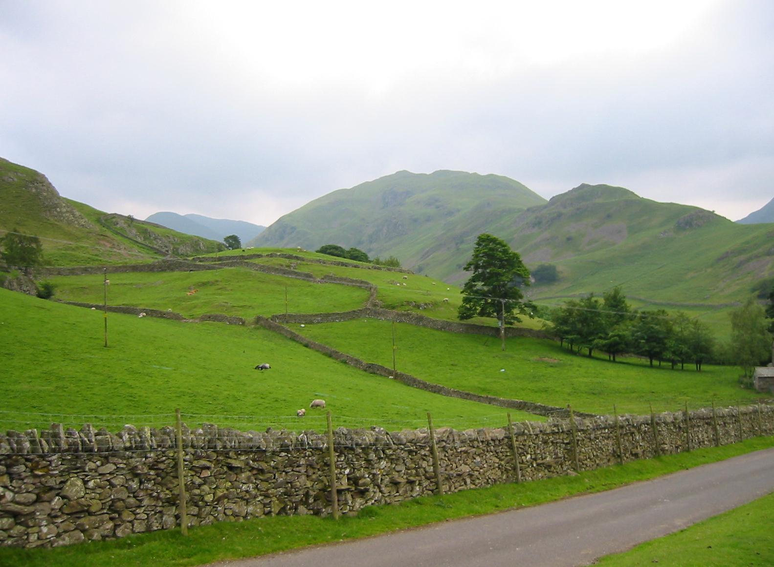
In Martindale
This was very lovely countryside in the late afternoon summer light and our way forward was mostly level through a series of gates and stiles adjacent to houses and farmsteads. Eventually we began a descent to a beck and after reaching a house at Bridgend we used its access road to cross Howe Grain Beck and Boardale Beck in short order – and so reach the road to Sandwick.
Before reaching this village, however, we were directed to take a track sheltered by a wall and we used this to climb westward. The reward at the end of this stretch was Scalehow Beck, where we sat down for a well-deserved rest. A lamb (sort of a teenager in size I would say) was bleating its heart out in separation anxiety here – but mom was nowhere to be seen.
Hannon says “here commences a walk in heaven,” and indeed, as views of the lake improved you could sympathize with the sentiment – but Tosh and I agreed that there was still too much up and down for heaven. That lady kept asking me for landmarks – “What are we looking for?” – but it was hard to be specific since much of the route was simply a slog along an undulating shelf heading increasingly in a southerly direction. I tried to suggest how many miles we still had to go (and this number fell ever so slowly) but often I could not say for sure where we were in our progress.
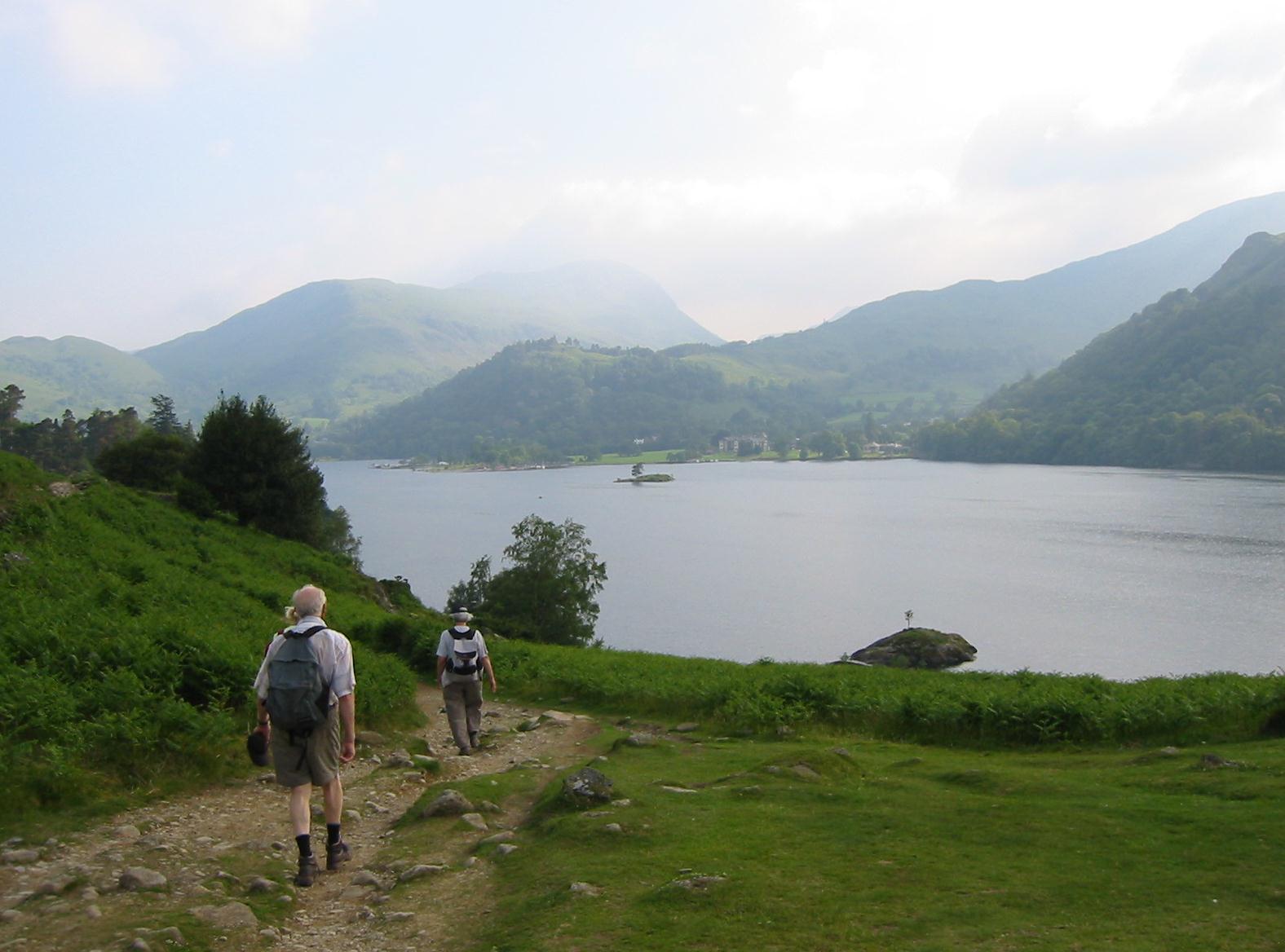
With Ullswater on our right, the Lees near Patterdale.
There was a right turn at Silver Point and as we rounded this spot the path seemed to dip a bit more closely toward the water’s edge. It was dinnertime and I was full of admiration for the many people who passed us in the opposite direction; they were lucky there was so much lingering daylight. Our legs were very tired now and this may explain why a simple misstep developed into a face first fall as we were attempting to speed toward the end. My glasses went flying and I hurt my right wrist, which had been wonky for a year or so, but otherwise I felt okay and was soon standing again. I must have bruised my chest a bit but I was lucky not to have been even more discomfited.
With half a mile to go we approached Side Farm (my mile 3800), which had become a city of tent dwellers. The popularity of this site will also explain why we were now encountering vehicles – including some rough looking bikers on expensive motorcycles. Here also were two young women with a dozy dog – but because he was not on lead and there were plenty of animals about, including two curious pigs, the girls were getting a scolding from another farmer with deficient teeth.
We could now see Patterdale across the valley and we followed roads out to the A592, the setting sun in our eyes, and at last approached the White Lion Hotel. It was 7:15 and we had survived a very strenuous thirteen-mile day.
Our backpacks were bellied up to the bar, waiting for us, and there were plenty of other customers fighting for attention here as well. Nevertheless the chap behind the bar detached himself and took us upstairs. Once again the girls shared a room (“High Street”) while Harold and I were in “St. Sunday’s Crag.” The room was very warm and we searched for ways to open windows.
We soon returned to the melee below and found a table for four. The place was full of bikers, walkers and what appeared to be a stag night octet. Once again there was an interminable wait for our meals (more Nobby’s Nuts) – it took almost an hour and the food did not arrive until after 9:00. I had a nice lasagna and, though I was offered garlic bread and a choice of potatoes as well, I managed to offend Dr. Atkins only the one time. I congratulated my troops on a job well done. We were all exhausted.
Harold and I each took a shower but sleep was not easy to come by. First there was the whizzing traffic and the headlights crisscrossing our ceiling, then there was the heat – and we still had plenty of bar noise below, especially from the guffawing young men. Finally, just as I nodded off, the fire alarm went off. A kid, experimenting with a boot warmer, had attempted to dry out his dad’s footwear, melting the latter in the process. We were soon informed that there was no need to evacuate and so, with the airwaves freighted with the tang of burnt boot, we fell back on our beds again.
To continue with the next stage of our walk you need: