
June 20, 2006: Underbarrow to Crooklands
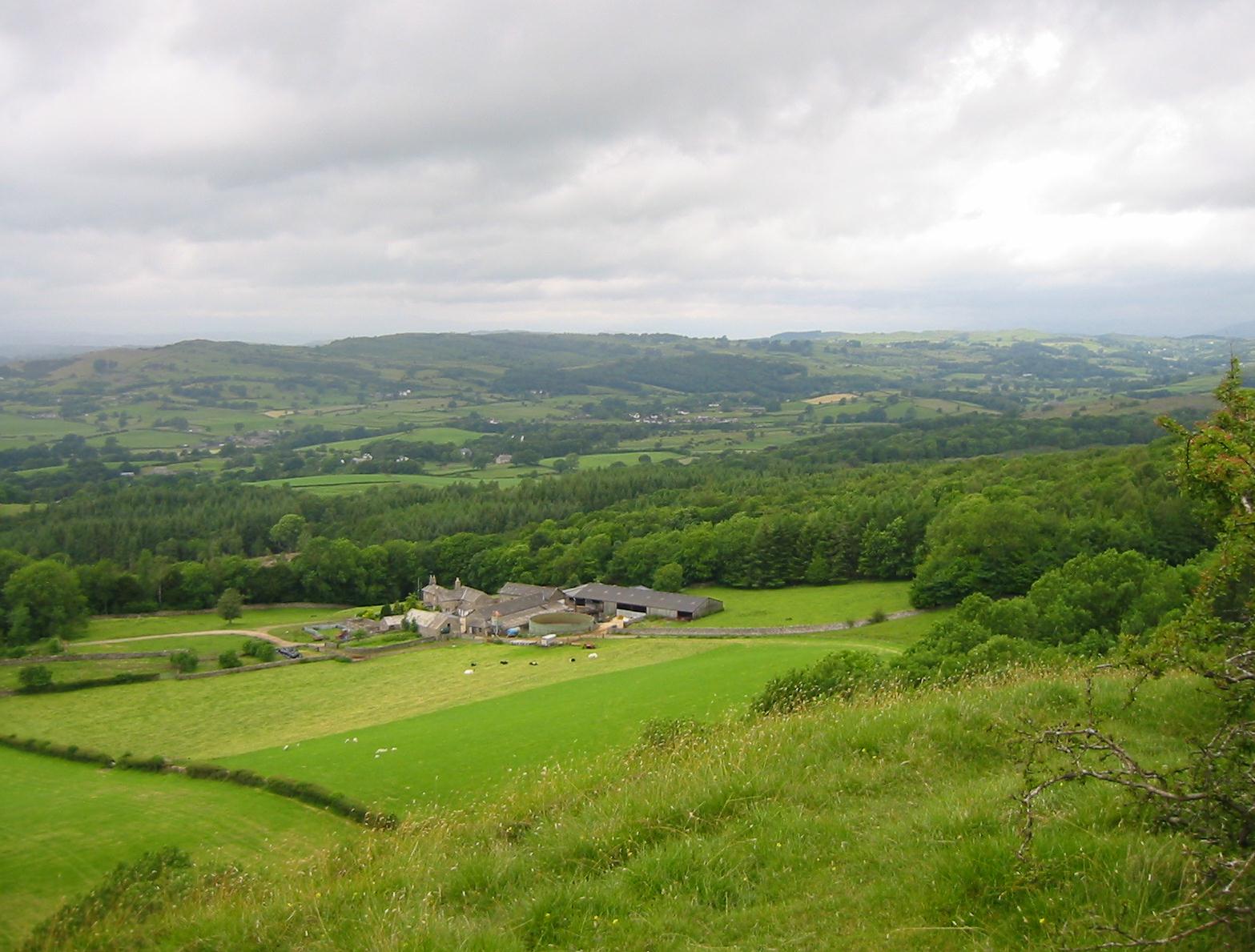
As we climb Scout Scar, a retrospective view of Barrowfield Farm
The weather was still cloudy bright as I pushed back the shutters of my window at the Highgate Hotel and peered into Kendal’s high street. Since our cabbie could only fit us in at 9:15, it was fortunate that they had an early breakfast hour here; we met at 8:00 and there was still some time for me, after my sausage and eggs, to have a stroll as I scouted out possible lunch locations for us later in the day – and took some pictures. I twice passed an authentic bearded lady; she was in the company of a small gaggle of damaged folk participating in some group outing. When I returned we brought our bags down for the Brigantes carrier (a woman, I later learned) and at precisely 9:15 Mr. Atlas pulled up.
Tosh, again unsettled by the drive here, took the front seat, but the most casual remark about the speed of yesterday’s journey seemed to do the trick – and things went far more smoothly. Our cabbie warned us that we would encounter rain just as we were climbing from his car at the Punchbowl in Underbarrow – where we started our walk at 9:25. This began with a tarmac turnoff on the Brigsteer road. There was still good visibility and much sun about so we were hoping that we could get the more strenuous portion of our thirteen-mile day over with before more bad weather.
After half a mile we left the roadway to climb over a stile and into a field on a path that brought us out on a new road, the one bearing the aforementioned Tullythwaite House. After passing this establishment we turned south, into a field, and began a bit of cross-country walking on grass. Ahead of us and on our left we now had the lengthy panorama of Scout Scar, a long north-south escarpment that dominated the eastern skyline. Climbing to its top would be our only substantial bit of uphill today.
As we reached a road we now passed an ancient lop-eared barn and I took several photos as we waited for Margie (one of the members of our party was always dropping back on this trip for some privacy). We took a dogleg to the right and headed for some houses, passing to the right of them and climbing onto a grassy hillside. The local footpath signs and Hannon’s directions did not quite match here, but I persevered in following the outline of his map and soon we had doubled back to face a stile into a large woodland, Barrowfield Lot, above us.
You could say that our ascent of Scout Scar had now begun for our route through the trees and out to a bracken-choked open area was mostly uphill. Hannon says that at the far end of this space the walker is confronted by a steep bank – and that the way forward is to slant off to the right. We found such a path but it was soon obvious that the next section of advertised woodland had been felled, and I was a bit anxious about following this path until it righted itself and headed for a stile on the eastern boundary of the former woodlot. In the field below us was an unusual sight: two male pheasants were having a duel in honor of the darting brown female at their side.
We crossed another grassy field and climbed up into another section of woods, this time intact, and then up another grassy field to the precincts of Barrowfield Farm. Some of the farm roads were quite muddy but we managed to dodge these as we climbed above the farm and approached more woods. A bleating lamb, menaced by our presence, leaped across the road in search of its mom, diving in for a drink as soon as the latter identified herself. Never a better example of food as an anxiety-suppressant.
We now began an ascent of Scout Scar proper, though our contour to the right did not have to go on for too long – as we had already made considerable upward progress. Views, backward to Lakeland and forward to the sea, were wonderful up here, and after turning back to the left we reached a large cairn that meant we had achieved the long summit plateau. There were lots of people up here and many rival paths, but these all headed north and we were soon moving forward on an exhilarating march over turf.
The Lees got well behind here, first because Tosh was examining rocks and second because she fell into conversation with some of the other walkers up here. Margie was out front and for a while I could see Harold behind me, but a few drops fell and he paused to put on his wet suit and I lost track of him. I wasn’t too worried because I had told the others to aim for the distant shelter and this Marge and I did ourselves. It was an interesting round structure with seats at the four corners and a mushroom roof – though quite open to the elements. At 764 feet, Scout Scar had been no more exhausting an ascent than School Knott the day before.
The Lees finally arrived, together, though approaching us on yet another path, and we had a bit of a rest. Then I began searching for a way through the stone wall on the east of the plateau and found it without too much difficulty, down to our left. There now began the easiest of descents into Kendal, spread out before us, with lots of nice turf to cushion our footfalls and stone walls to serve as guideposts. We encountered quite a few people and their dogs chugging up in the opposite direction as we reached flatter territory at Fisher’s Tenement Farm. Our route swerved around this large place before using its access road to swing around to the Brigsteer-Kendal Road.
We now had quite a bit of road walking, first over the Kendal bypass and then, as we reached the town itself, past houses and gardens, often with the assistance of pavement. After a turn onto Gillingate we descended rapidly past many a house and place of business sporting the red and white English flag – a symphony of patriotic display due to football frenzy. Margie darted across the street to mail some of her myriad postcards and we were soon at a corner of Highgate itself – only a block from our former hotel. We turned right, however, because I had spotted on my morning walk, just beyond the parish church, a likely looking noontime pub, the Ring ‘O Bells. Here we settled down in the snug and ordered our drinks. It was 12:20.
The lady publican was quite a character, though she must have thought we were too when Tosh asked her to turn the television set off. Harold and I had the battered cod and chips (he passed on the mushy peas) though there was more batter than cod by the time this food arrived. The bar lady spent a lot of time in our room since she was trying to escape from a chap “who could talk the hind leg off a donkey – give him six Drambuies and he’s anybody’s.” We still had about seven and a half miles to go, so we didn’t dawdle. Everybody visited the loos and we left at 1:25. It was still bright enough for me to wear my sunglasses.
We had to cross the Nether Bridge over the River Kent and hunt for a crosswalk that allowed us to walk along the pavement of a southerly highway. We passed outlets and factories (or outlets in former factories) and then reached more suburban surroundings. I was looking for a turnoff to the right and at last it appeared, though the path in question lead only to the parking lot of a working factory. Hannon had warned us of this development and so we persevered in substandard surroundings and at last reached more open country near Watercrook. Still, our path passed through rather mucky territory before approaching the river itself, where prospects improved. Indeed we stayed too close to the river and had to double back to reach an escape stile onto a high bank separated from the swift-moving water by a line of trees.
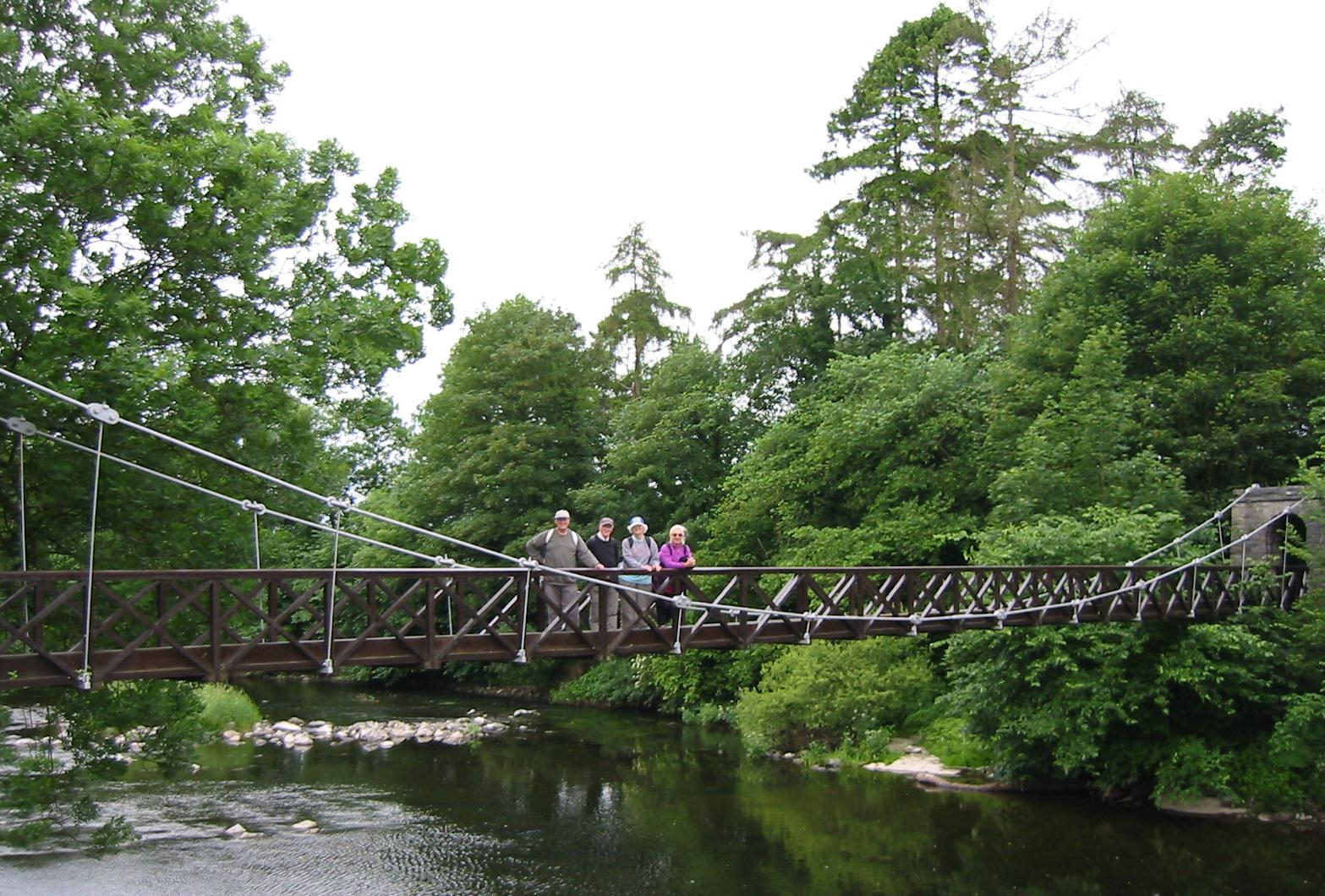
Our party on the suspension bridge over the River Kent
We headed south for quite a distance on easy paths that allowed a relatively fast pace. At Hawes Bridge we had a peek down at the gorge below us, a very impressive sight. Then there followed another long section with the river over on our right. In this section we often met up with a woman who walking with the assistance of a cane and a Westie. But when we left woodland behind and began to edge along a large field she turned around – not wanting to manage her dog in such close proximity to cows. Just before reaching the buildings of Wilson Place we spotted a suspension bridge that would take us to the west side of the Kent. I took a picture of the others approaching this structure but some other trippers were here and one guy offered to take a picture of all four of us in mid-river (“and I won’t run off with your camera”) and so we posed in this fashion before I retrieved the camera and followed the others in a bouncy fashion over the bridge.
We continued in our southerly direction on roads now, dodging the caravans and ruing the fact that a teashop was off route. After a turnoff on the Sizergh road we crossed the Kent for the last time and climbed into a field at the foot of Sedgwick House – here we sat down for a rest in the long grass. The skies had been darkening in the last few minutes and we could now feel a few drops of rain, but the decision to put on our rain gear had to wait until we had climbed up to the Hincaster-Sedgwick road, where it started raining in earnest. Unfortunately I now forgot to take my sweatshirt off – but I did remove my cap and soon I was swathed in the rubberized hood of my rain jacket, with visibility extremely restricted and my glasses useless once again.
We were now on an overland transition stage, moving between the River Kent and the Lancaster Canal. There was a bit of a path up to an old redundant bridge here, but thereafter there was considerable ambiguity about how to continue up and to the left. Tosh wanted to escape via the nearest gate but I kept insisting that we needed to make progress to the brow of the hill. At last I found the right stile and we crossed a second Hincaster-Sedgwick road. We now had only a small hill to climb to obtain a view of the railway line and again I was full of trepidation over this moment, especially so since I now realized that the South East Sheet did not, in fact, cover this territory and that Sheet 97 was still in my big backpack – not my daypack. If we were blocked here it would be quite a struggle finding our way forward.
From my restricted view (no lateral vision whatsoever) I could just see the railway line and Margie and Tosh moving off to the left. This was puzzling until I reached the spot myself and realized that a pedestrian bridge had been built over the line here and that our crossing would not be impeded. I was delighted. On the other side, however, our way eastward did not correspond precisely with Hannon’s maps (he has us on one side of a fence, the waymarks pointed to the other side) but the fences themselves hadn’t changed position and I was able to find a route out to the Natland Road. Here we turned south again on tarmac and continued down to a road junction, where some steps lead to the start of the Lancaster Canal.
I was a bit confused here. Although water and towpath lead us only one way I had expected a southerly direction and we were heading east (much compass work here). Finally I realized that the canal did indeed begin with a brief east-west section and soon we had rounded a corner and assumed the right direction. Almost immediately we encountered a lovely swan family, mom, dad and six cygnets. Margie had been saving bread for this occasion and it was charming to see how the adults let the kids dive for these morsels without grabbing any for themselves.
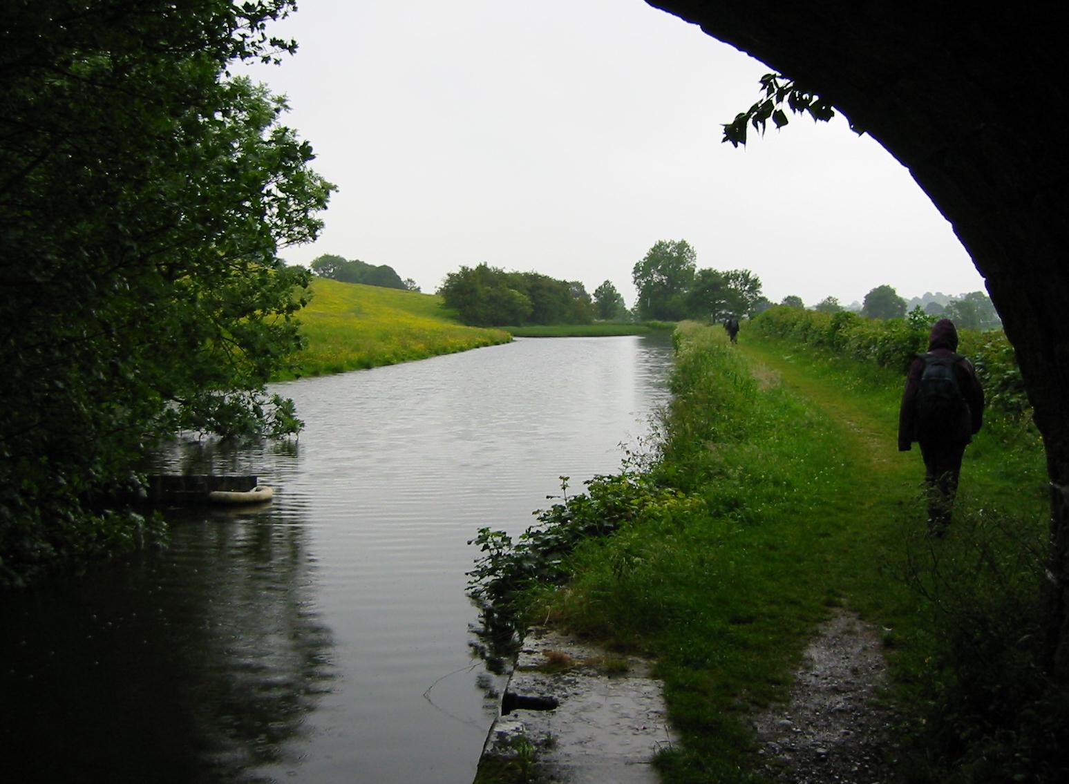
The Lancaster Canal in the rain
The remaining two miles of our journey would have been easy walking had it not been for the rain, which now increased in intensity, and the wind – blowing in our faces and slowing us down. I think I took only one picture, storing the camera in the rain jacket pocket, the one that didn’t already contain my glasses. Progress was measured here by bridges and we encountered five of these before approaching the Crooklands bridge itself. I had several options for leaving the towpath but I chose one just before the bridge, which we now crossed against heavy traffic, soon encountering the Crooklands Hotel across another busy street. It was 5:45 and we had walked thirteen miles.
This large motel, which catered for the business and M6 traveller, was designed with only the motorist in mind –and we had a devil of a time finding an entryway for mere pedestrians. Inside the layout was quite confusing – the Minotaur must have had a hand in putting this floor plan together – and things weren’t made any easier for me when the others darted ahead and I could not guess which direction they had taken. I wandered through the dining room and the bar and at last found a route to reception, where Tosh had already negotiated a third room. Our receptionist was a larger than life very attractive young lady who seemed to be bursting out of her clothes. Most of her hair was blonde but she had colored the front wings in brown. She now went to fetch our bags (“What have you got in here, rocks?”) and we made a dinner reservation for 6:45 – an early start for us because of the upcoming England-Sweden match.
In my room I stripped off all my wet clothes and laid them out to dry, though this time I could get no heat from either towel rail or radiatior. My boots weren’t too damp but I stuffed them with newspapers too. I took a shower, phoned Dorothy, and reported to the dining room, where we had our drinks while the food was being prepared. Tonight I had the pork chops (or were those my own boots again?). I drank a pint while the Lees sipped wine and debated whether there was time for dessert. Things moved quite slowly, though, curiously, the adjacent bar was clearly not going to be offering any football to its patrons.
The Lees invited us to their room to watch the game, already thirteen minutes old. We had missed Michael Owen’s serious knee injury and, sprawled out on one of the beds, I kept dozing off anyway. I excused myself at half time and turned the set on in my own room (the only time on this trip I did so) and kept myself awake only to see England blow a chance of victory by conceding a late goal that ended the contest at 2-2 (England finished top of their group anyway). Then I had a last look into the parking lot (it was still raining) and went to bed.
To continue with the next stage of our walk you need: