
August 1, 2009: Tralee to Camp
I cross the Blennerville Bridge.
As I ran down the hall at 5:45 on the morning on Friday, July 31, I experienced a small twinge in the top of my left foot. It was one of those nagging injuries (the right foot was acting up in the same way) that seem to fulfill my pre-trip need for medical anxieties these days. Half asleep, I was running down the hall to answer the phone. It was Gavan, calling to tell me that he was already on his way from Heathrow at the start of this year’s major walking expedition, eight days on Ireland’s Dingle Way.
Most of the anxieties in the planning of this trip had centered on the problem of getting Gavan, who had driven to Boston from Hartford after a day of work on Thursday, from his incoming flight at Heathrow to Stansted – in time for our 10:10 flight to Kerry International Airport. It seemed simple enough in the planning stages: Gavan would take the Heathrow Express to Paddington, I would meet him there, together we would take the underground to Liverpool Street – and then the train to Stansted. That was before the train employees of National Express (which was already about to lose this franchise) had decided to help matters along with a little industrial action. For two weeks we fretted by email on alternate strategies before I decided that it would be best for Gavan just to take a cab to my place from Paddington Station – where a second one would be waiting to whisk us to the airport. I was reasonably confident in this approach because Gavan’s BA flight had been running early all week. Today, indeed, he was quickly through arrivals with his Irish passport, his bag was waiting for him, and he had time to take the underground to Maida Vale – even time for a shower.
I finished the last of my packing while he did this and then I noticed that the minicab from Airport Executive Cars was already parked across the street, twenty minutes early. Soon our luggage was aboard (Gavan had brought only a suitcase this time) and we were off at 7:00. Traffic wasn’t too bad but our cabbie kept well within city limits until he had arrived in Hackney – often choosing little side streets with speed bumps to further our progress. Just as we reached the motorway we had the cheering presence of the 2012 Olympics buildings, rising on our right in scaffolding. It took only one hour and five minutes to complete the journey to an airport I had not visited since our arrival on a trip from Sweden thirty years ago.
We had to change check-in areas once and my backpack had to go through a special chute, but we were soon at security, where belts and boots had to come off. A very nice security lady informed me that I couldn’t take a squeeze bottle of sun-blocker with me aboard the plane; I had forgotten it was in my daypack and, since I was going to Ireland, I didn’t expect to feel its loss too acutely. The airport was crowded and noisy, a babble of tongues and accents, but we sat down in front of a monitor and began our wait. Behind us the barflies erupted every time someone recorded a dismissal in the latest version of the Ashes on TV.
It was a long wait – for soon our flight was bearing the ominous designation, “expecting 11:55.” I got out the mobile phone to let Nathan Murphy at Celtic Trails know that the taxi man, who had been ordered for us in Kerry, would now have to keep his eye open for a new arrival time. Then I got out my puzzle book and went to work. When our designation changed to “expecting 12:55” I suggested we have our lunch in the airport, and we were soon seated in a New York Italian deli where I had a black pepper encrusted cheeseburger. We were now up to “expecting 1:55” but this time there were no further delays and we were soon in a crush of passengers waiting to escape the gate and dash toward either end of the plane – since Ryan Air does not assign seats to the ordinary passenger. In the event we were airborne at 2:35, over four hours late – the consequence, we learned, of our plane having had to divert to Gerona to pick up some stranded vacationers. (At least I think that was the explanation; the steward had a strong Hungarian accent.) Skies were lowering when we landed in Kerry, the wings of the plane dipping up and down in a strong wind at 3:45. Late as it was, there still seemed to be time to undertake several errands in Tralee – but first we had to get there. No sign of any cab.
We waited around for ten minutes or so and then I fished out the mobile phone to speak to Claire, Celtic Trails’ rep on the Dingle Way. After several delays and missed calls she reported that our taxi had obviously not bothered to check on the changed arrival time and had left (and that she wouldn’t be ordering us a new one.) So we were on our own. There seemed to be a place for taxis outside, next to the bus halt (all buses to Tralee had finished their runs for the day) but there were no drivers in evidence –and it was beginning to rain. We waited for a while in the overhang of the airport bar’s smokers’ lounge. I went inside the tiny “international” airport to ask if someone could call a taxi for us but this seemed unlikely. After a frustrating half an hour a cab came in with arriving passengers and we joined a woman and her little girl in our escape.
Our driver, John O’Leary, said that an accident at a nearby roundabout was holding traffic up and soon we were in a queue that passed a smashed car whose roof was being cut off by firemen. Our ride lasted only twenty minutes or so, the other passengers getting off in a suburban housing estate first. John could answer every one of our questions on life in Tralee and so we were well entertained. The sun was also coming out as we arrived in downtown and we were soon outside the doors of the Tralee Townhouse on the High Street.
No one answered our ring but a chap from a nearby estate agents had spotted us and came over to let us in. Of course he could find no record of our booking but, while he was fussing over this and other details of our needs, Eleanor Collins arrived from her break and soon found our reservation. We were sent up to a nice room on the fourth floor by lift and here we unpacked a bit before setting off to do Tralee. It was 5:00.
This was a very interesting town, full of antique charm and modern amenities as well. John O’Leary had told me that the best place to find Irish Ordnance Survey Maps was at Eason’s Bookstore. I headed here, Gavan having an errand at a nearby sporting good store where he had been asked to pick up a local football jersey for a colleague. I located sheets 70 and 71 but they had no Dingle Way guidebooks (though Celtic Trails had sent us one already). Our purchases in hand, Gavan next visited a cash machine while I took a number of pictures. Then we walked down to the modern Siamsa Tire theatre where Gavan had booked tickets for tonight’s performance of Oilean, a production of the National Folk Theatre of Ireland, a celebration of the life of the Blasket Islanders – whose abandoned home we would pass in a few days.
Then it was time for our first Irish pint at Quirkie’s bar, where pool players battled away beneath the sports screen. We each had a Guinness and celebrated our arrival at last – all ready for what we knew would be a great adventure.
John O’Leary had recommend Kirby’s Brogue Inn as a place to eat and we found places at this steakhouse around the corner. Gavan had the fried brie and plaice, I the cod and chips. A large family of Spaniards occupied a nearby table. We did not dawdle as it was now close to 8:00 and we had to repeat our walk to the theatre, passing a dole office – where one window had been smashed in by a disappointed job seeker.
The show began at 8:30 and it was very well done; lots of dance (some in the Riverdance mode) and music played on discordant instruments – fiddle, accordion and so on. Gavan has a great fascination for the story of the islanders who, en masse, decided half a century ago to abandon their home off the western edge of the peninsula and resettle on the mainland, and throughout the trip he continued to read the autobiography of Peig Sayers, who was one of the immigrants. Unfortunately both of us started to nod off (Gavan having a better excuse for this than I did) and things were rather repetitious on stage so we decided to depart at intermission. It was dark outside now; we had only a seven-minute walk back to our b&b and we were comfortably tucked up in bed soon thereafter.
In the morning we headed for the breakfast room at eight and here we each consumed a full Irish breakfast, one that included both white and black pudding as well as sausages, bacon, eggs and toast. In our room we made the final adjustments to our packs and I slipped the guidebook and a folded section of the first OS map (sheet 71) into its plastic case. On this trip we would use the Rucksack Reader guide written by Sandra Bardwell and Jacquetta Megarry, the same team who had written the guide to last year’s Great Glen Way. The maps in this spiral-bound production were quite deficient – with many places in the text not visible on the map at all – and distances were measured only in the broadest scope – rather than in the mile-by-mile manner craved by most walkers. As a consequence I had to begin each day by laboriously measuring out the miles (using a scale at the bottom of the OS map), adding these to the map’s surface myself. On the whole this worked pretty well – but it was a nuisance.
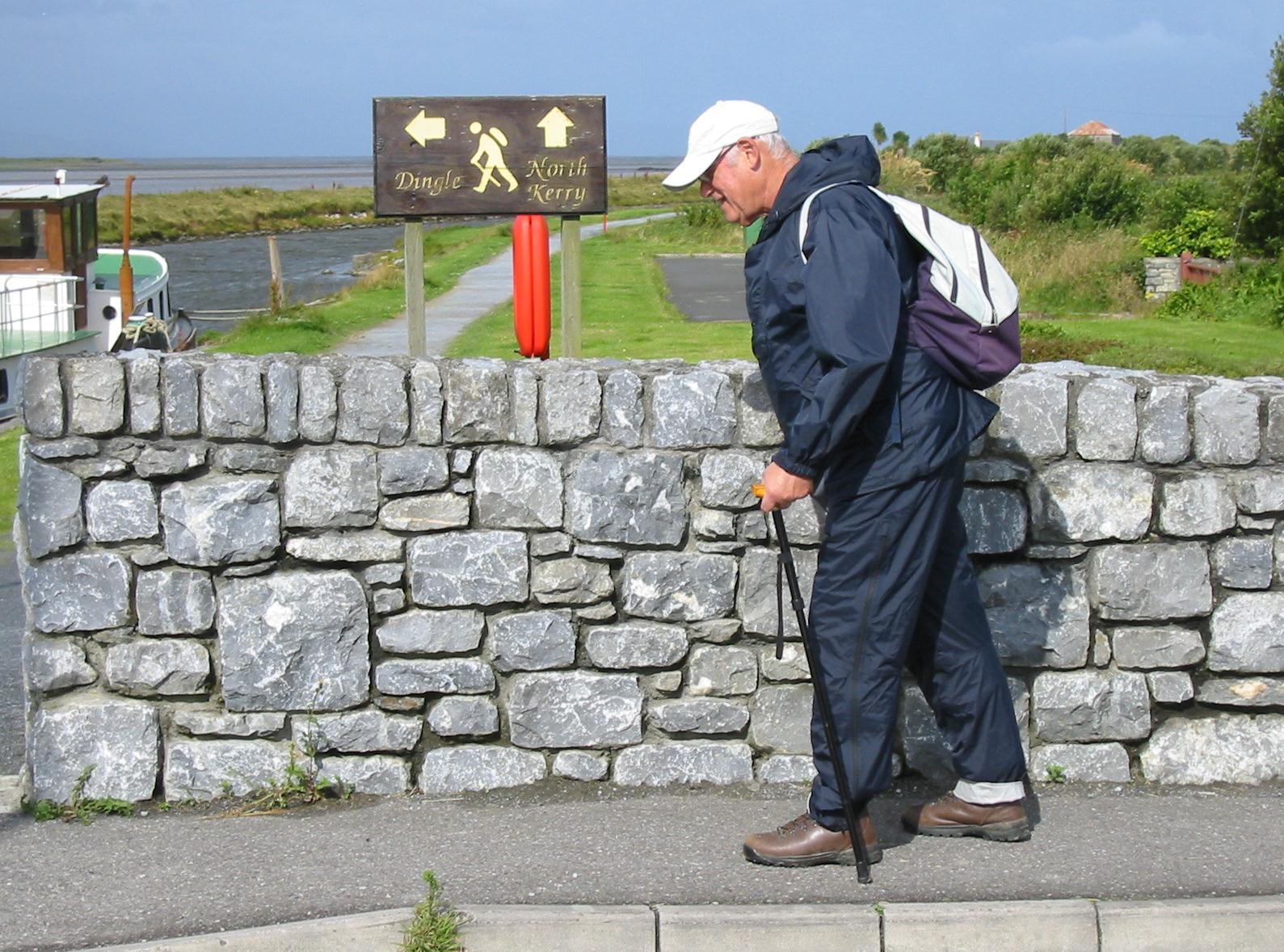
We brought our bags down, leaving them at reception for their eventual transfer to our next accommodation, receiving in return our packed lunches. It was 9:15 but our progress for the next fifteen minutes was slow. It had been raining and I was now wearing my raingear as we made our way though the grey windy air and past the motor repair shop of “Jim Caball himself.” We returned to last night’s theatre since, nearby, was the actual start of our route, opposite the Thomas Ashe Memorial Hall. The latter, which also houses the Kerry County Museum, was decorated this morning with pictures of the forty-nine previous winners of the Rose of Tralee pageant – soon to celebrate its fiftieth incarnation. We posed before the Dingle Way signboard and took one another’s pictures and also shots of the Celtic crosses and statues in the grounds of the theatre. By 9:30 we were ready to make our exit from Kerry’s capital city.
At a roundabout Gavan pointed out to me that some puritanical county official had painted out the word “Dingle” from the road sign. This was obviously a gesture undertaken on behalf of the Gaelic purity of this world – Kerry being one of those regions where the Irish tongue was widely spoken and the use of English (however helpful this might be to the casual tourist) discouraged. There were rumors that this policy may be reversed in the future but it was irksome to come across Dingle Way notices (such as those advising alternative routes) in Gaelic only.
The route we were about to undertake has been described as leaf-shaped, a leaf with a stem, a stem which takes the walker westward to Camp at the start and then back again to Tralee at the end – though we had no intention of walking the stem a second time. We began our westward journey along the N86, soon escaping this busy thoroughfare for a gentle stroll along a canal towpath. Once some other walkers came up behind us but most of those we encountered were locals walking their dogs or jogging along for the exercise. The skies were beginning to brighten and this was a most gentle start. But any resemblance between this route and the Great Glen Way would soon disappear for good.
We passed an unusual large thatched structure, over on the highway, and a line of suburban houses over on our right. Slowly we approached the village of Blennerville, its distant windmill inviting us forward. A bridge brought us over the canal and the River Lee and here Gavan posed me in front of a Dingle waymark, one which featured a walker bent forward with cane and knapsack – in short a figure I could easily resemble. Curious cows with labels in their ears watched as we passed over the bridge and then we continued forward through the village in a southerly direction, escaping to follow a minor road first east then south again. At a junction we turned west, pursued by a few joggers, making our way forward on tarmac to our next southerly turnoff – a road that began to climb steadily for almost a mile as we pulled into the foothills of the Slieve Mish Mountains.
Just before we left the comfortable surface of this road for the footpaths of the Way I paused for a pee, a drink, and a change of clothes – it was sunny at this point and I decided to take my rain jacket off. Then we began the long moorland crossing, one that would bring us, after seven or so miles, into Camp village. It would be a memorable passage in more ways than one.
Of course use of the word “path” was itself questionable here, given the nature of the route we were expected to take. There may have been occasional steppingstones but most of what we faced was at best a wild arrangement of uneven rocky stones and wet, muddy patches, a progress that was almost always rising or falling like a bucking bronco. Since it was such a featureless (though quite lovely) environment it was almost impossible to know how far we had come, though Gavan (who usually carried the map case on this trip) was adept at gauging our progress by studying the indentations of the shoreline below us.
There were not many clues in the guidebook itself and references to signs, which would have been useful in fixing our location, were often useless – since these were by now missing. The suggestion that you had to cross three small streams in order to reach the Curraheen River was insufficient since there were streams everywhere – the path itself was often a streambed as well. A bridge took us over the river and we continued forward, searching for our next landmark, the Derryquay River. There was a brief shower and I had to resume full raingear. At least the route was well waymarked.
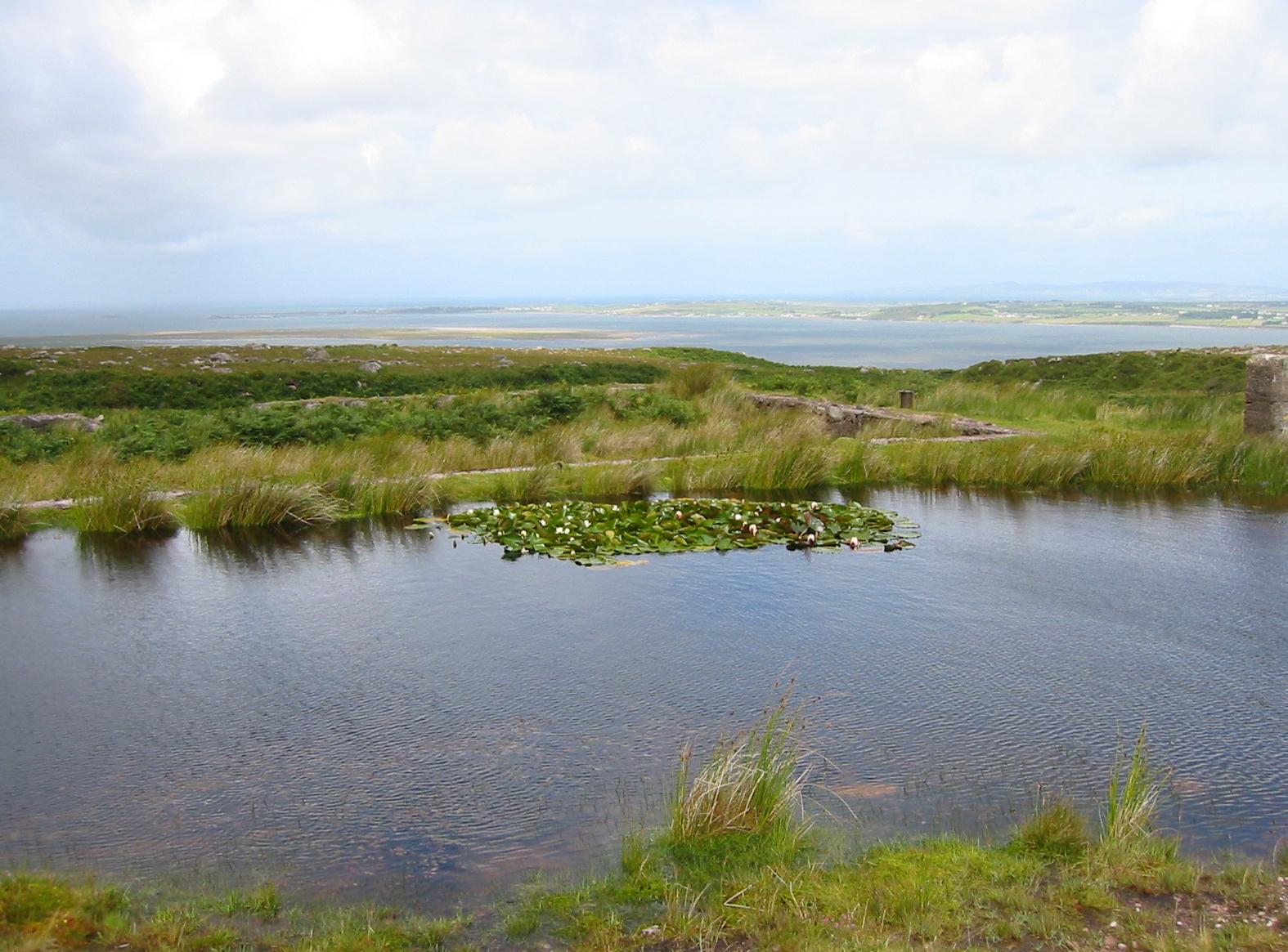
Water lilies on the moorland path to Camp
After a while I began to slip and fall. Once I fell forward and cracked both of my knees on the rocks. On another occasion I slipped into a bog on my left, my entire arm plunged into the gloop up to my shoulder. Gavan had to pull me out of this mess, worried that I would pull him in. (At least I discovered that Dorothy’s Swatch was water-resistant.) We paused only rarely, once for lunch and once before crossing the Derryquay River and climbing steeply up its far side on muddy paths in the bracken. On our left, in mockery, there was a most lovely scene, with many waterfalls descending and on our right ponds with lilies growing on their surface. I was also drinking a lot of water, two bottles worth – partly because of the rigors of the route and partly because of all the salt in this morning’s rashers.
I was using my cane, as I do on all walks these days, and I had many misadventures with this object. It was useful to have it, for it gave me purchase on the rocky surfaces and a way of gauging the depth of puddles, but the rubber tip began to give real problems, remaining embedded in the mud as the rest of the cane was pulled away. Gavan twice helped me dig it out of the mud, using a stone as a trenching tool, but on a third occasion it disappeared and no amount of digging was of any use – it was lost forever.
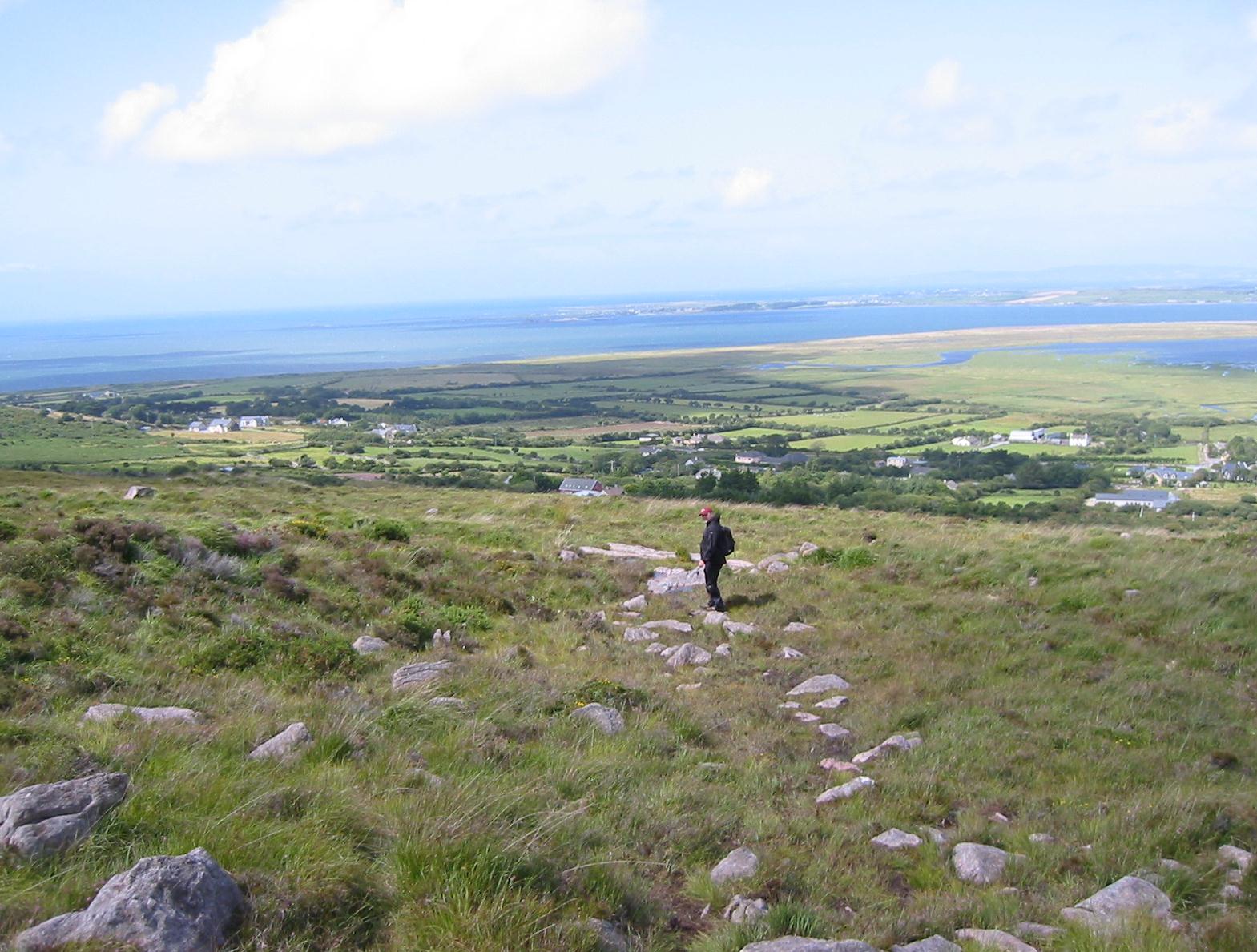
Gavan on the descent to Killerton
Railway sleepers helped us get over some boggy areas but there were plenty of rocks to cross as we headed for the Derrymore River. Something of a track appeared in the region of Killerton and nearby I could see that we were also nearing the main highway as well. Seeking some relief from the treacherous and uneven surfaces we had been wrestling with I proposed that we complete our journey on the N86 itself. Gavan crossed a field and we found a track down to a gate, which we climbed. Here was the highway itself and I crossed this – prepared for a quick march into Camp, still two and a half miles ahead of us. It was already 4:00 or so.
Gavan hung back for a pee but when he joined me it was obvious that he was agitated by our dangerous proximity to all the whizzing traffic. Tosh shares this phobia and so it did not surprise me that he now asked if we couldn’t return to our original route. I agreed and so we retraced our steps, re-climbed the gate, and used a track to rise to the “sometime” road, one that we would follow for the next few miles. Once this had been the Tralee-Dingle road itself and so surfaces were a little more humane than out on the moorland, but there were also more stiles and gates.
We passed the ruins of Killerton church and pressed doggedly forward among growing signs of civilization: fences, farmhouses, even an add for our own b&b, though there was no way it was only one kilometer away (after another mile we found the sign again; it too said the b&b was only one kilometer away). To our surprise our way forward was now to be shared with two teenage girls, one with an American accent. It was adding insult to injury to note that they were able to negotiate this portion of the route in flip-flops!
We began a descent to the Finglass River and my heart sank when we saw signs suggesting that when the river is in spate a complex detour would be needed to reach Camp itself. To our relief, however, the steppingstones across the swiftly flowing river were all above the surface and we were soon bouncing across them on our way to the other side. It was extremely dark under the overhanging foliage but Gavan had me pause so that he could take a shot with his new mini Canon camera. It flashed.
We now climbed up to the junction of our route with the road to Camp, on the right, and to Dingle itself on the left. Photos were taken here too and Gavan then took some shots of the two of us in one of those roadside mirrors that drivers use in dangerous corners. Our descent to Camp was gentle enough and the skies were still bright. Near the bottom a family made up of several generations (including a little girl in a pink coat) dashed past us and Gavan received a nod of assent from the dad when he said, “Late for the 6:30 mass?” A minute later someone was speaking to Gavan; this was our landlady, Kathleen Daly, also on her way to mass, but anxious to identify her lost lodgers and to advise them how to locate her husband Peter “in the bar.” It had taken us nine (real) hours to walk eleven (alleged) miles.
We assumed that the bar in question was that of James Ashe, on the corner, and as we knew we had an evening meal booked here, we entered to look for Mr. Daly. The proprietor said that we could come back for dinner whenever we wanted – but that Mr. Daly would be found in his own bar, across the street. Sure enough next to our b&b, the pink Finglas House, stood Daly’s Bar; its proprietor, in suspenders and shirtsleeves, was just emerging from the b&b and he let us in. We took off our boots and found our way to a comfortable room on the first floor – Gavan lugging my heavy pack upstairs for me, as he did on most nights.
We each took a shower and I attempted to rinse a layer of muck off my rain pants at the same time. Unfortunately the shower drain was somewhat clogged and all this grit was slow to disappear. I kept having to rinse more of it down at odd intervals, even the next morning. I was now able to have a look at my knees and this was not a cheery sight. The right one had a black and blue mark but the left had a pink welt on its surface – though my feet were just fine. I used some Deep Heat, Gavan beginning his ritual objection to its strong minty odor and, at 7:30, we crossed the road to enter Ashe’s bar for a second time.
I got our drinks from the bar – often a protracted process since Gavan’s Guinness required a bit of quiet time before being filled to the top. The waitress explained that as Celtic Trails clients we could have any starter, main dish and dessert we wanted. Tonight we each ordered the salmon and had a very nice and relaxing meal. Gavan had a second pint and, light at last fading from the skies, we returned to Finglas House for an early night. We deserved one.
To continue with the next stage our walk you need: