
October 22, 2000: Hamstreet to Rye
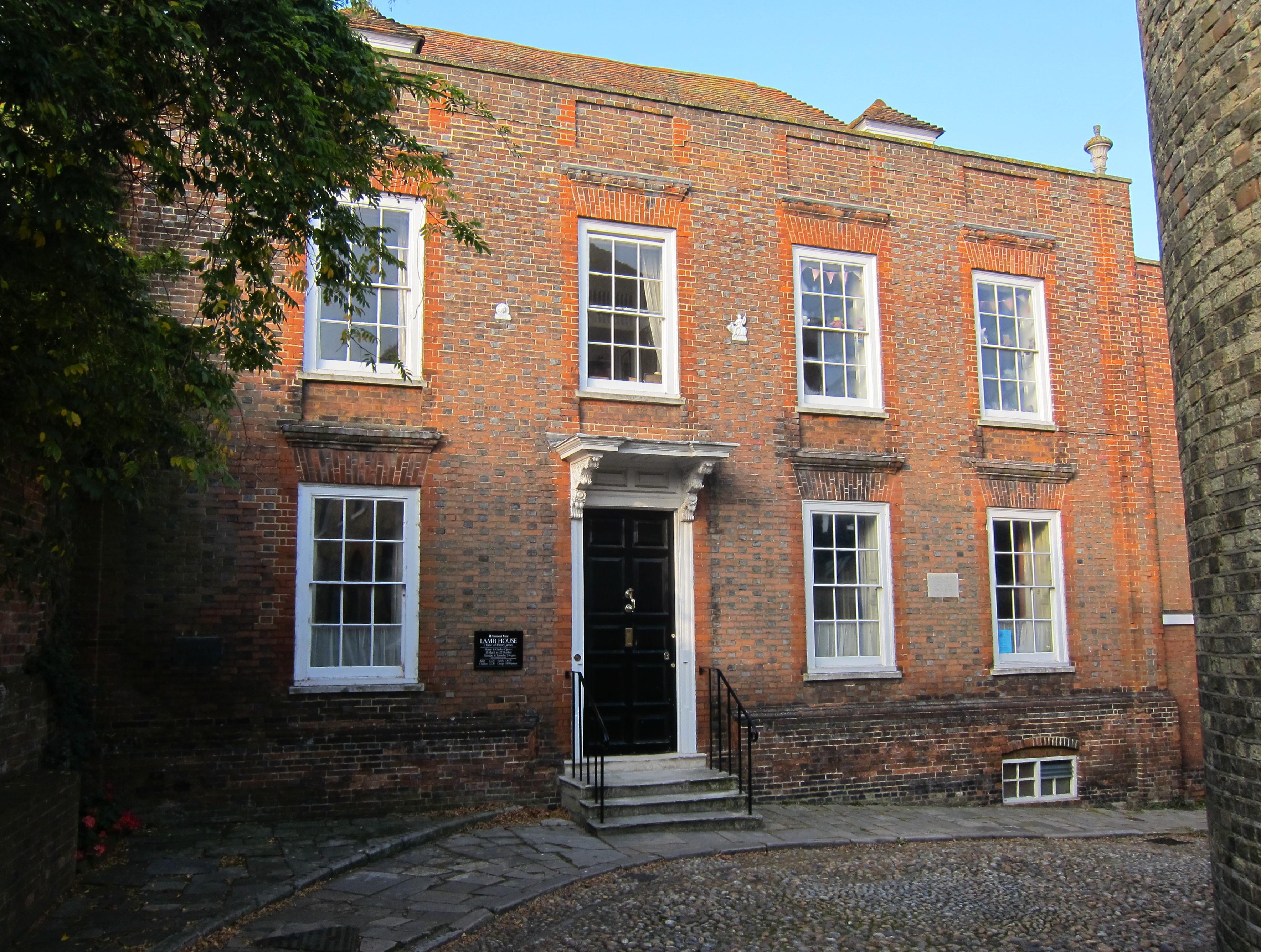
Lamb House, the home of Henry James, in Rye
Some two months after the completion of our Coast-to-Coast walk, the much-traveled Lees agreed to join me in the next-to-last stage of the Saxon Shore Way. The weekend had been extended for me by a two-day October school break – and so I was happy to note that a strenuous Sunday march would be complimented by two days of rest.
Over the Internet I had done some research on travel arrangements, and the news was not good. Coastal Kent is a long way from north London, under any circumstances, but on this Sunday (at the end of a week in which there had been two derailments) Railtrack was promising only one decent morning connection to Hamstreet, a 9:22 train from, of all places, Elephant and Castle.
I set out at 8:00, not at all confident that I could get south of Piccadilly Circus on the Bakerloo Line, but in this case engineering works had shortened this to no further south than Paddington. At the latter I switched, after a nine-minute wait, to an eastbound Circle Line train. This came to a halt west of Farringdon, but the delay was not too long. I switched again at Moorgate, where the down escalator was not working, and reached the foot of the lift at E&C shortly before 9:00. I wasn’t quite sure how to find the Thameslink Station and wandered about in the mist outside before discovering a sign that suggested a likely transit through a nearby shopping center. When I got to the station the Lees were just arriving (They too had been discomfited by the Bakerloo Line and had, at one point, jumped into a cab.) There was nobody about and though the monitors did list our train to Ashford you couldn’t buy a ticket there from the machine, nor were they willing to tell us which platform to use until two minutes before departure time – when we had to complete a mad dash to platform 4. With the conductor I confirmed that this is where we wanted to be – and we threw ourselves aboard one of the train’s grotty compartments.
We then stopped at every station in suburbia and Kent as we crawled southward. The conductor, a cheery young lad with a brown forelock, a yellow tie and a blue coat, eventually agreed to take some money from us on Connex’s behalf – though he punched the wrong buttons and had to start all over. He was looking forward to reading the Sunday papers and he had forgotten all about us – after having been troubled by some young layabouts who wouldn’t produce tickets and therefore had to be thrown off the train twice. I had a lot of school gossip to share with Tosh so things weren’t too boring and, shortly after 11:00, we reached Ashford.
The Lemon Tree Cafe was closed and so was the ladies loo, though Tosh was shown into the baby’s changing room – only to be followed by an indignant punk who also wanted to use the facilities. “Fucking hell,” he exploded. He was wearing a white jumper that had been slashed and dotted with red paint to simulate blood and he had made sure that these stains decorated his bare arms as well.
We headed for our platform, found an open Lemon Tree here and bought some food, just in case the pub I was aiming for was closed. Our train took off a bit late but shortly after 11:30 we stepped off at Hamstreet, where we had last been in June. (Apologies, incidentally, for the lack of consistency in the spelling of the name of this village on this website. The OS map and the guidebook have it as Hamstreet; the platform sign clearly prefers Ham Street.) On this day we were making an extremely late start for us, and, with over twelve miles to go, I knew that we would really have to keep on trucking if we were to make it to Rye by nightfall.
I found the path, actually the final steps of the Greensand Way, and we followed it east, back to the parking lot where we had parted company with the Saxon Shore Way last time. Then, with a lot of Sunday drivers about, we headed south on tarmac, entered the village of Hamstreet for first time and then turned west to cross a very busy road, and to continue by road ourselves toward our first adventure with mud. It was grey and a bit damp this morning, but it was not raining today; the region had been beset by heavy rainfall in the last few weeks and there had been much flooding – so we were anxious to see what the surfaces were like today.
We passed beneath the railway line and turned left up some steps. I paused to roll up my pant legs, which was just as well – because, after a climbing a stile, we had to take off in a southwesterly direction (our compass point for most of this day) across a grassy field that swept moisture into the boots. These never became sodden, but the feet remained damp from this point on. We could already see the buildings of Warehorne village ahead of us and by the time we had climbed up to its church we were on solid footing again and almost opposite our noontime stop, The Woolpack. It was 12:10.
I warned the Lees about the need for a swift stop (and Tosh not to advertise the presence of our damp boots) and we were lucky enough to have ordered our food and got our drinks before the noontime mob arrived. The pub was very nice, with hops hanging from the rafters, and we were served rapidly. Tosh had liver, Harold cod and chips, but I, who had eaten a Twix on the platform at Ashford, had just a spicy vegetable soup, roll and butter (plus a handful of Tosh’s chips, too). The Lees were very good about not ordering coffee and so, after we had all used the loos, we were able to depart at about 1:50.
At the access to Tinton Manor Farm, just beyond the village, we turned off the road, squeezing ourselves through a very muddy patch next to a gate, and turning southwest again. I noticed that the wet grass cleaned the mud off my boots a treat. All around us was Romney Marsh territory but our footing seemed solid enough, if damp. Our object now was St. Mary’s, Kenardington, but to reach it we had to cross one of the many feeders into the Military Canal (the Horsemarsh Sewer) and climb a hillside to approach the church on our right.
The waymarking was again quite good today, but after passing the church and crossing a field we missed a sign, following other public footpath arrows, evidently, to reach a bit of tarmac farther east than we were supposed to be. The same thing had happened on our last walk, and so I was sure that our heading west would eventually lead us to a crossing of the lost SSW. We passed a lovely cottage, the Firs, and I was soon reassured to see other walkers in the field on our right; they were heading in a direction opposite ours, but I was certain they must be on our path. Sure enough, after several hundred years, we reached a crossing point, more green SSW signs, and here we turned left to enter a field of low crops bisected by a sinuous trail in the clay.
This path climbed up to a dramatic hillock and we edged ourselves around the right hand side, just as we began to get some patchy sunlight, to pick up a continuation on the other side – though the descent lead through a field of turnips, or so it would seem. We crossed a plank bridge and made our way through several additional fields, observing the direction of the arrow on the Saxon Shore Way badges very carefully –and before long we had reached the outskirts of civilization and the road into Appledore. Here there were some loos that we all used. In the urinal a dead frog (still half tadpole) was floating disconsolately.
I was a bit disconsolate myself because we really didn’t have time to visit any of Appledore’s pubs; instead we made our way on pavements past the ivy-covered buildings (the fall colors had turned these a lovely red) and turned right at a T-junction along Court Lodge Road. Some wooden steps lead up to the ridge known as Mill Mound but at the highest point I could see no way forward. Here I decided I needed to have a look at the compass. The scene below was full of fields and canals but in the grey light I wasn’t quite certain which direction to head and when I looked at the compass I discovered that we needed to turn to our right to pursue the westward course of the SSW. There didn’t seem to be any path down there but we persevered in our descent and were rewarded by a sign pointing forward along one of the canals. Footing was often rough along the margins of this waterway, with only a suggestion of a true footpath, and our feet and legs were beginning to ache.
When we reached the road at Stone Ferry I suggested that we now had an alternative. I had noticed that the SSW made a wide western sweep before returning to the road at a spot where it reached the village of Stone-in-Oxney. We could save ten or fifteen minutes and maybe even earn enough time to have a quick drink at the town pub if we took to the road immediately. This was agreed to and shortly after 3:00 we reached The Crown, which was going strong in a miasma of cigarette smoke. I had a double Grouse on the rocks (my first alcohol for the day) and we again used the loos. The publican himself was just two urinals away, and I complimented him on the role of the Crown as an oasis for walkers. He agreed that he did get many of this tribe. I told him we were trying to make Rye before nightfall. “Should do,” he replied, “It’s only five miles.”
We left at about 3:40 and took a minor road uphill and past yet another St. Mary’s Church. (Today’s walk would be a great one for admirers of country churches, for they were all lovely – and for admirers of a lovely pint as well.) At another T-junction we climbed a stile and headed to the top of Stone Cliff, where there were wonderful views over the Rother Levels ahead – though on this murky day we never saw the sea. We now began a steep descent, often guessing a bit on the right route in the grass, and followed minor drains in a southerly direction. We turned left at the Kent Ditch – the border between Kent, which we would now be leaving behind after almost twelve days of walking, and East Sussex. A bridge over a minor canal brought us out onto the Military Road, where we improvised a crossing of a fence in order to climb the embankment of the Military Canal itself.
Here we turned right, following a path that appeared in fits and starts under the canal side foliage. Across the way fisherfolk were packing up for the day. We were forced back onto the road at Iden Lock, but soon we were waterside again. The footing was very rough and when we reached the Boonshill Bridge I suggested we abandon the embankment for some straightforward if tedious road walking. Tosh was reluctant to walk into the traffic in the gloaming but this was a long open stretch and her pink sweater was certainly visible at great distances. At Scott’s Float we resumed our walk along the embankment, the River Rother now on our right. I would have liked to take a shortcut to the distant railway bridge, but Tosh was reluctant to try this. Ahead we could see the buildings of Rye looming in the distance.
I was doing a lot of looking at my watch, since I not only wanted to beat the darkness but make a 5:51 train. We passed beneath the bridge and followed one more field path out to the A259. This we crossed to take a path over the bridge reserved for walkers and cyclists. The SSW turned left to follow the water and we sped ahead, the River Brede on or left, pausing every now and then to ask for directions to the train station. As we wandered around at the summit plateau of this very charming town I was surprised to discover a site that would hold particular interest for any teacher of American literature – Lamb House, the home of Henry James.
We were holding a debate over whether there were likely to be loos at train station when we passed a set of public conveniences on our left. The station cafe, I noticed, was called The Fat Controller. I remember when station caffs were proudly called The Belly Buster.
It was 5:36. We had just climbed over the bridge to the other side of the tracks to wait for an Ashford train when I happened to notice that, at this time of day, the best connection was via Hastings at 5:47. So we climbed over the bridge a second time (the red orange sun was just setting) and joined the other passengers who were waiting for a westbound train. It was slightly late but we climbed aboard and squeezed into our seats. Quite a few stops followed, but a Charing Cross train was waiting for us at an adjacent platform when we arrived in Hastings. We still had a two-hour journey. During the first few minutes we ate the food we had bought in Ashford. I phoned Dorothy and we all dozed a bit.
Dorothy had advised me not to bother with a repetition of my arduous underground journey so at Charing Cross I waited in a short queue for a cab. It was shortly after 9:00 when I at last reached home, quite tired from the adventure. Except for our two pub stops we had completed twelve miles without once stopping or sitting down and the feet and the legs really felt it. I had a hot shower, drank a bottle of beer, and went to bed soon after 10:00
To continue with the next stage of our walk you need: