
August 2, 2012: Cley-Next-The-Sea to Cromer
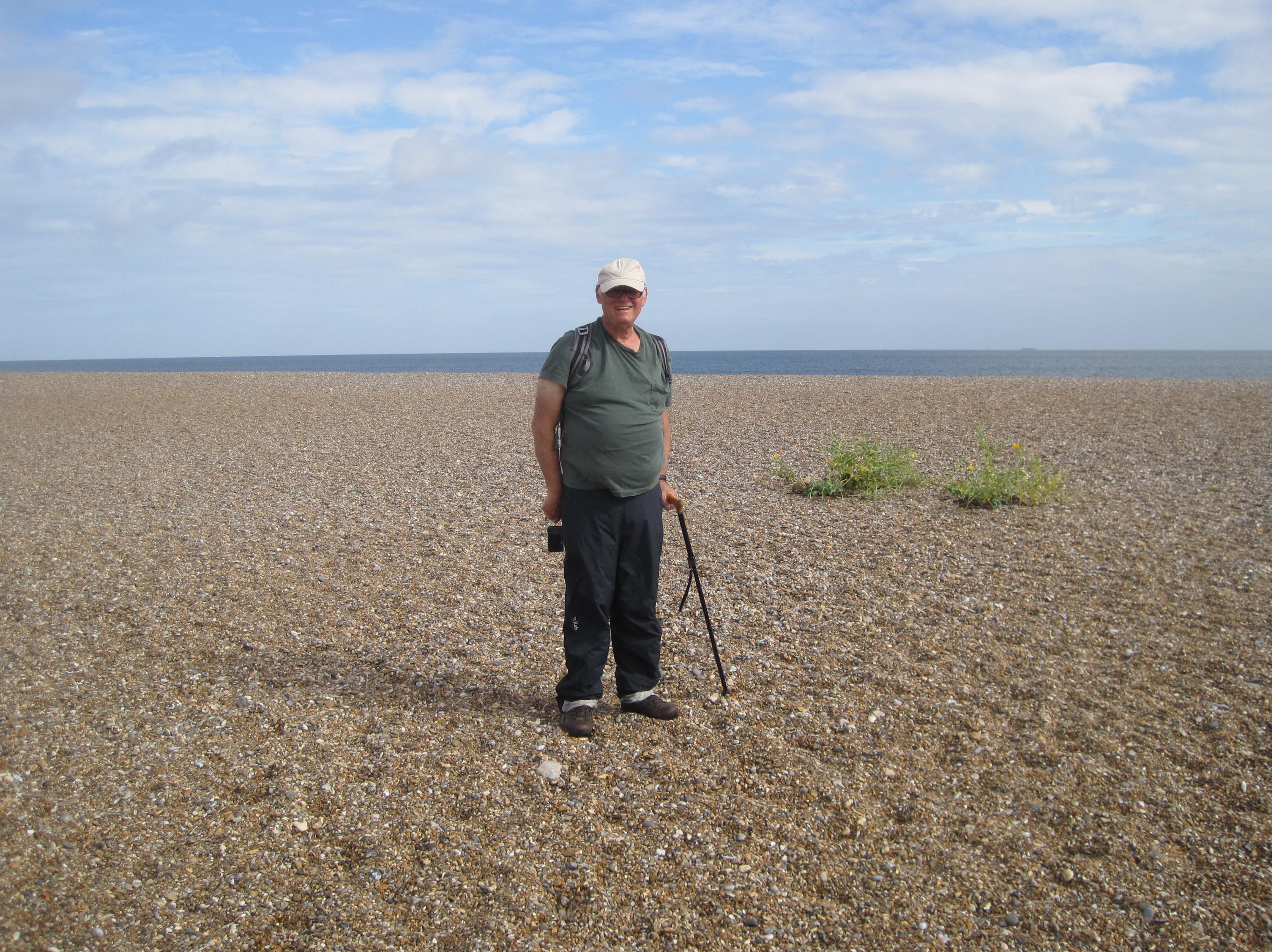
I wouldn’t be smiling for long as we encounter
our first taste of shingle a mile or so after leaving Cley.
The weather seemed bright enough as we arose for our fourth and last day of walking on the Norfolk Coast Path. It would be a very long day and, in order to outrace the competition at breakfast, we made our way into the dining room of Cookes at about 8:25. An efficient young woman soon had our orders – I was back to straight scrambled eggs on toast. She told us we could leave our bags in our rooms and by 9:10 we were able to hit the streets.
Just a few yards down the road there was an alleyway that permitted us to return to the coast path, the windmill now on our left. Now we could head out to sea again and begin a northerly journey atop the sea bank. This was very easy walking and just as well – for my right foot, which seemed to have no problems in my trainers, was again in protest mode. We passed a wartime gun cupola, with flowers growing out of its turret, and gradually reached the sea itself – how unusual that a “coast path” did this so rarely.
On our right we had the Cley Marshes, a famous bird sanctuary and, indeed, we saw many members of the twitching fraternity setting up their observations posts as we made our way in an easterly direction. The stretch ahead of us was inhospitable in the extreme – not because of the views available in every direction for these were wonderful – but because footing was uncertain a best. We passed through a parking lot with a sculpture that looked like a bedspread and faced a scene of and dunes and shingle…our fate for the next four miles!
Occasionally there were solid sections on the inland side of the dune, where a little grass grew, and the dune tops themselves provided some smaller versions of the rocks that covered most surfaces but, on the whole, there was nothing to do but march forward resolutely – with every footstep sinking into the shifting shingle. I found it easier to step heel first and after an hour or so my foot gave up its protests and it was not heard from again on this day.
The sun was often quite strong here (my face accepted a deep tan) and I had to pause to take on liquid a number of times. Both Gavan and I also paused to take a lot of pictures, particularly when a sudden rise in elevation permitted panoramic views up and down the coast. On the inland side the scene was again dominated by a large windmill – this one near the town of Weybourne.
Eventually the path began to rise and fall as we entered a region famous for its cliff tops. Each time we reached another elevation rise I held out hopes that we had seen the last of the shingle but I was often disappointed. There were lots of people, and their dogs, to share the path with as we struggled up some of these heights. Off to our right we had a golf course (with several balls landing quite near us) and in the background we could see the smoke rising from the whistling steam railway, the North Norfolk Railway’s Poppy Line.
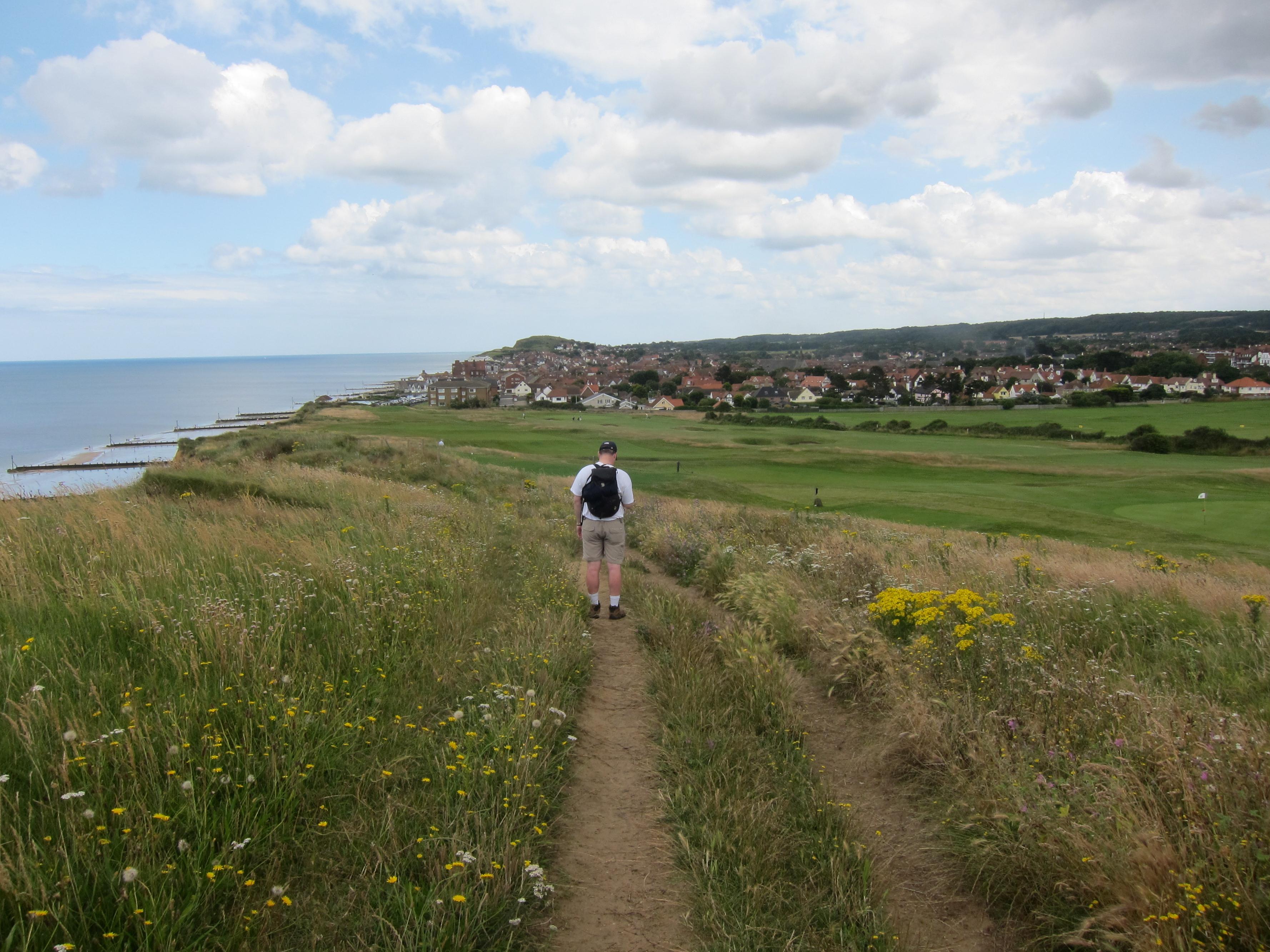
Is Gavan studying Sheringham – or his phone?
A lookout station on Skelding Hill was our last summit before a dramatic view of Sheringham came into focus. This quite large town was now very near and we bounced downhill with thoughts of cold beer urging us on. It was already past 1:00 and we had covered close to eight miles. We walked along a seafront esplanade, past a large tank meant for miniature motor yachts, as we searched on our right for a likely looking pub. We could see the entrance to the bar of a large red brick hotel, the Burlington, so we decided to give this a try. Other people were still eating in the almost empty place and this was encouraging but the ladies at reception told us that chef had gone home early – at 1:20! Nevertheless one of these efficient staff members said she should make us some sandwiches and she wrote down our orders and drew us our pints.
I had a tuna sandwich and a pint of Kronenbourg. When Gavan sipped his beer he noted, “This one actually tastes like cider.” “But Strongbow is a cider,” I had to advise him. We ate our food and relaxed a bit and at 2:20 we were were able to resume our trod, with five and a half miles still to go.
We now passed the rest of Sheringham’s seafront – with all of England, it seemed, busily enjoying the holiday scene. Most of them were eating something… fish and chips and a turquoise-colored ice cream among the great favorites. We fought our way through this mass and climbed some steps to pass a pitch and putt golf course and climb yet another steep hill. This was Beeston Hill and from its summit we could see all the way to Cromer.
We could see all the way to Cromer but there was no orderly progress along the cliff tops to reach this destination – for the Norfolk Coast Path, for some reason, has a sting in its tail. Instead of a straightforward march on Cromer we would have to turn inland and complete a semi-circle, whose apex was a wooded hilltop high above us on the right. To reach this spot we descended our hill and turned right to cross the rail line and a highway, heading away from the sea on unpaved roads past farmsteads, old and new, and gradually rising on the sunny slopes ahead of us. We passed Beeston Hall and an old cottage and continued our climb, with a huge field on our left. A farmer in a tractor was bringing some food out to the animals and he was soon being trailed by cows and sheep – even some huge horses condescended to trot forward slowly in order to see what was going on.
It was quite warm in the sun and I rested every time I could get to some shade. But this problem soon came to an end as, after a stretch of Calves Well Lane, we entered woodland, following paths and large trees ever upward. Some of our track was very wet and our boots tasted mud for the first time on this trip. At last we reached the ridgetop road and headed in a southeasterly direction on it – soon entering a posh neighborhood with some fine houses. On our left a flagpole, with National Trust colors flying, stood atop a little hillock – evidently, at 346 feet, the highest elevation in Norfolk.
I often enjoy inland diversions while walking coast paths – for they do provide a needed variety to the scene – but Gavan and I were soon less than happy with this one and the reason was obvious – we had to share our road surfaces with a large number of cars (even a taxi). In addition to the traffic that was part of the local agricultural scene we also had a number of caravan compounds and tented campsites to add to the traffic. Our direction was an easterly one, on the whole, and we had a good deal of downhill – but we were forever stepping off the track in order to permit the passage of another vehicle. We passed beneath an attractive railway arch and Gavan found a bench for us to sit on – while a huge tractor backed up in front of us.
There was even one last hill to climb in the hot afternoon sun as we neared the suburban outskirts of Cromer itself. We now walked along a street of a new housing estate – where an Indian mother and two children stared at us suspiciously. Crossing this street and rounding a corner brought us near a graveyard and the railway station and then we followed busy streets around a complex dominated by a Morrisons, using Beach Road to reach the seafront at Runton Road.
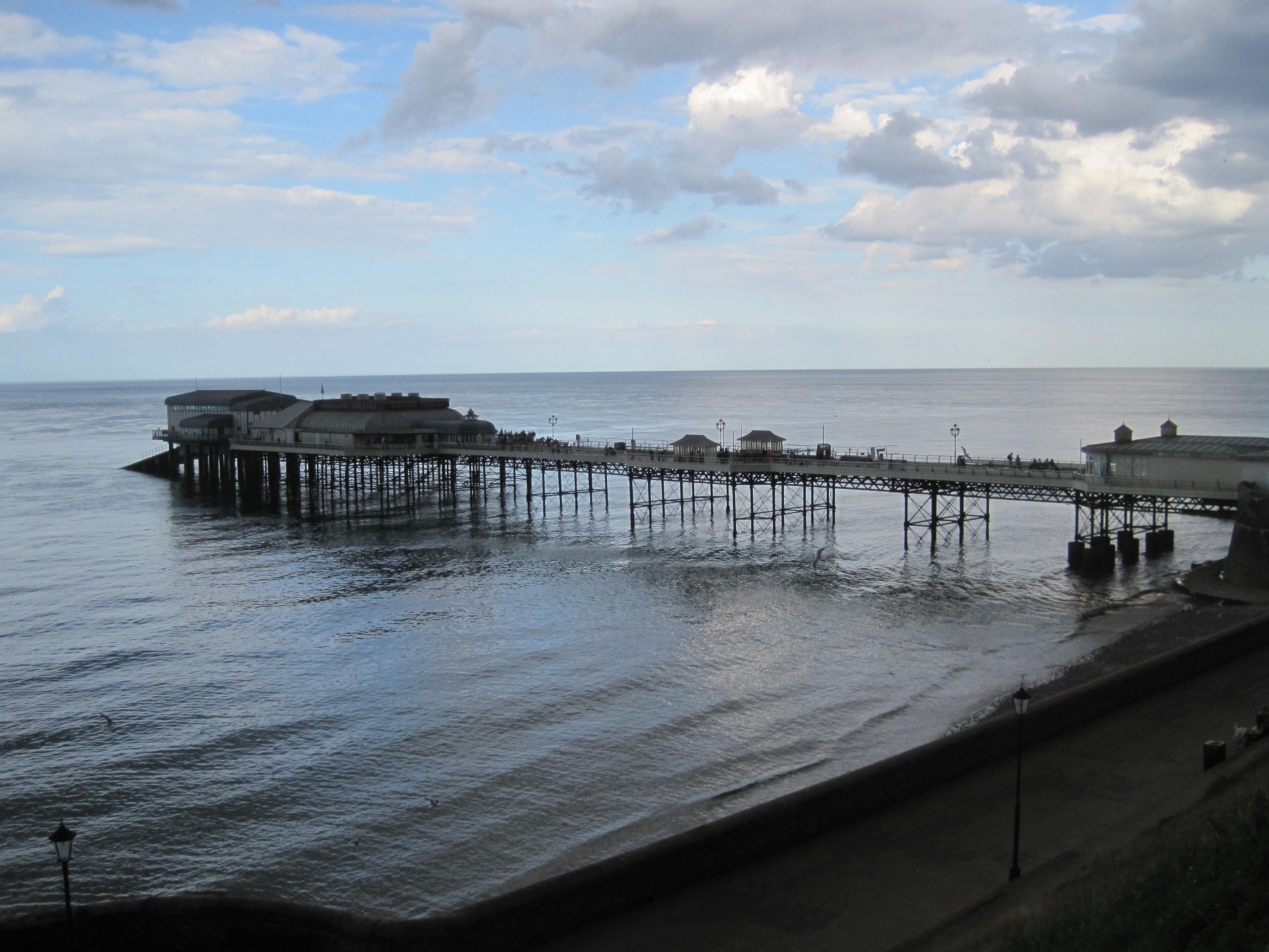
The end is in sight: the pier at Cromer.
On our right we could see the Cromer Pier and we walked along the promenade toward this spot, arriving at 5:35 – after another 13.5-mile day. Celebratory shots were taken against the backdrop of the finger post pointing back to Hunstanton – but these were poor examples of the photographer’s art for it was impossible to ignore the fact that, after such a sunny afternoon, skies were darkening rapidly and that rain appeared imminent.
Sitting at the outdoor table of a pub I fished out my telephone and called the taxi company that was supposed to take us back to our night’s accommodation. I suggested they look for us in front of the nearby Morrisons service station and shop – for here we could find some shelter from the impending storm – and we were promised a pickup in ten minutes. So we marched back to Runton Road and I went inside the shop to buy some more Diet Coke and some candy bars.
We sat on a low cement wall and searched the traffic for signs of our cab and at last it came. No sooner had we climbed into the back seat then the heavens opened! Our destination was the village of West Runton (Celtic Trails having run up against another local festival in Cromer itself when searching for accommodation here) and so we headed west. Our driver, another knowledgeable and accommodating chap, said that he had been part of a rescue team that had spent many a long hour on our shingle beach. He advised us on where to eat and drink in West Runton and maneuvered his cars skillfully into the forecourt of the Old Barn so that we had only a short dash to the front yard.
We were greeted by our proprietor, Karen, and shown to rooms on the first floor – where we could see that the back yard sprinkler was still adding its voice to the rain. We cleaned up a bit in the tiny bathroom (you could sit on the toilet and wash your feet in the shower at the same time) and then we headed out, passing the village church across the street and squeezing through a parking lot to approach the Village Inn.
We dined in the bar and Gavan took on the responsibility of erasing the lobster entrée from the chalkboard menu with a wet cloth – as this famous shellfish was off, dear.
I had the lasagna and a rhubarb and ginger crumble with custard and Gavan had the lamb shanks. The place was very busy but we had a nice leisurely meal at the end of a very successful outing.
Back at the Old Barn we spent some time in the grand sitting room on the ground floor – where miniature framed portraits of the family’s children flanked one of the family dog. Then it was upstairs for more Olympics on the telly.
Karen had agreed to give us an early breakfast, 7:30, for we had an 8:27 train to catch on Friday, August 3rd. We began our march to the West Runton halt at about 8:15, therefore, and it was only a short distance away. I paused for one last photo (of a frog crossing warning sign) on the railway bridge and we descended to the flowery station below. Gavan had already figured out that our shuttle would reverse directions in Cromer and so it did – making many stops as it chugged on to Norwich.
Here we changed trains to one for Liverpool Street, with only five minutes to go before it took off at 9:30. Lads with a huge crate of beer were preparing for a day at the Olympics by getting well-oiled. Gavan too was heading directly for the games but first we had to find a taxi. An Olympics volunteer told us how to do this when we arrived at Liverpool Street at 11:15 and we were soon heading for Maida Vale. At home Gavan got off with our luggage and a set of the house keys – while I kept the cab for a long-delayed visit to Sainsbury Ladbroke Grove. Thus it was 1:30 or so before I reached the welcome confines of my home base – having completed now both halves of the famous Peddars Way and Norfolk Coast Path.
Footpath Index:
England: A Chilterns Hundred | The Chiltern Way | The Cleveland Way | The Coast-to-Coast Path | The Coleridge Way | The Cotswold Way | The Cumberland Way | The Cumbria Way | The Dales Way | The Furness Way | The Green London Way | The Greensand Way | The Isle of Wight Coast Path | The London Countryway | The London Outer Orbital Path | The Norfolk Coast Path | The North Downs Way | The Northumberland Coast Path | The Peddars Way | The Pennine Way | The Ridgeway Path | The Roman Way | The Saxon Shore Way | The South Downs Way | The South West Coast Path | The Thames Path | The Two Moors Way | The Vanguard Way | The Wealdway | The Westmorland Way | The White Peak Way | The Yorkshire Wolds Way
Ireland: The Dingle Way | The Wicklow Way
Scotland: The Great Glen Way | The Rob Roy Way | The Speyside Way | The West Highland Way
Wales: Glyndwr’s Way | Offa’s Dyke Path
Channel Islands: The Guernsey Coastal Walk | The Jersey Coastal Walk