
May 25, 1985: Sandling to Dover
Shakespeare’s Cliff, Aycliffe
Day 15 – the last. Almost a year had passed before the right day came along on which to complete the Folkestone loop and, with it, the entire length of the North Downs Way. To me the time had seemed much longer than this, for in the interval I had managed seventeen days of walking and moved my total mileage from 650 to 800+. Even this day, when the weather and the hours of daylight seemed at last favorable, proved inconvenient for Tosh, who had a rehearsal – so it was just Dorothy, Harold, Bertie and I who met at Charing Cross on Saturday, May 25, 1985 – at 8:10.
Harold and Dorothy went into the burger bar for coffee (forgetting to ask for black) and came back with luscious cream-filled eclairs. These we consumed after we had boarded the 8:25 to Dover. Even without Tosh it was surprising how much school gossip Dorothy could generate. Bertie had his first bowl of water and one bite of pastry.
We left the train at Sandling at 9:45 and re-crossed the bridge – with Bertie balking at the open risers – so that the others could use the loos. These were locked. The station had a deserted air, its lot empty of the cars we had encountered on a weekday on our previous visit.
I lead a steady plod along the tarmac edges as we headed north in search of our NDW turnoff. The clouds were thinning out and it was already 20 degrees warmer than two Saturdays ago. The hedgerows were rich in wildflowers. We passed the “disease-free pigs” of a nearby farm and at last came abreast the spire of the farmyard church at Postling. I was reminded all over again of my chagrin at losing the line of the route near this spot last time.
We had regained our turnoff point near Staple Farm about 10:30. Here we had a roadside rest and a change of clothes. The sun was breaking through and it was time to strip down. I took off my blue sweatshirt but as soon as we started up the hill a cool breeze hit us and I complained of being cold. This condition did not last long. Though I often wore the sleeves of the sweatshirt around my neck I never again put the garment on.
Bertie was not yet off his new green extendo-lead, for the slope was dotted with sheep and he was mighty curious. There was no path on this grass but I kept fairly close to the fence, as the map indicated, and before long we were circling a wireless station’s perimeter fence. High above us a British telecom engineer was making adjustments to the mast.
When we cleared the last fence I freed Bertie and we continued along a saddle, quite close to both edges, with steep valleys on both sides. To the north we had views of Etchinghill and its hospital. A sharp left turn in this direction brought a descent through a lovely wood. At its end we were back in a sheep-filled field and Bertie was re-hooked as he was handed over a stile. This ritual was repeated many times on this day. Only once did we come across animals suddenly – and then he was very good about sitting immediately. Sheep, cows, and horses were all quite common today. The horses, quietly grazing and not making that awful clip-clop sound, raised no voice of protest from the dog today.
At the bottom of our route was the busy B2065. We dashed across it and down the track to Coombe Farm, whose back pasture we descended in pursuit of a promised style in the far right corner. This materialized and we ducked beneath the arch of the abandoned Folkestone-Canterbury railway line. Then we made a diagonal march uphill to the right and located a path that ascended the left side of a narrow sheep-choked valley. These beasts scurried from our path but one, lying quietly on the trail, elicited a series of snap diagnoses. “That one must be dead,” Dorothy said. “Or sick,” Harold added. “It could just be asleep,” I ventured. I steered the dog around the recumbent lamb who, after we had passed, leapt to its feet and ran after mom. The floor of this ever-steeper gulch, to use Harold’s word, was riddled with rabbit holes and many of the bunny-wunnies were dashing between them. “Look, Bertie,” I said, “it’s Watership Down.” The keen-eyed intelligent dog, for his part, never seemed to spot any of these beasties.
There was some ambiguity about how to proceed at the top of the ravine. Harold went up to the fence at the top, but there was no way over it or around it so I felt certain that we must have reached the “swing right on the highest available path and follow the fence south” point in the guidebook. This proved to be correct. We kept next to the fence around a few more bends, with everything well marked again, and in the corner of a field beneath some trees we paused for our first food break. There were no beasts around so Bertie was released. Dorothy tried to get some sun, but it was still pretty pale and there was a cool breeze blowing up the hill. I ate one of my sandwiches and had a swig of bitter lemon.
We then walked through grassy fields next to fences until it was time to enter the lane to Hungar Down. Dorothy, first over the stile, gave a gasp: the overhanging foliage had helped preserve a giant mud puddle for us. Bertie, who found a hole in the fence, rushed through to have a drink and a paddle. Dorothy inched forward along the marshy edge of the lane, while Harold caught his pack on an overhanging bramble and had to be freed by me, bringing up the rear. For this
gesture of good will I was rewarded by a squirt of mud that flew up at me with Harold’s next step. It caught me in the chest, the sleeve of my sweatshirt, my cheek, and the inside brim of my white cap. Dorothy removed some of this when we reached firmer ground and the rest was left to dry on its own.
When we reached the Arpinge road there was good news, for the guidebook implied that the official route uses tarmac whereas the dotted alternative, described only as a path favored by locals, now proved to be the official route. I waved to some walkers on the road below us as we circled a field and continued safely above the traffic. We switched to a quarry road and used some steps to ascend a chalk pit. Above us the first of half a dozen hang gliding enthusiasts lolled majestically in an updraft. His shadow actually startled the dog as he swooped by. I waved and he returned the salute.
We now had before us the full panorama of our cliff top route stretching up the coastline on our right and, sprawling below us, Folkestone. This town and its suburbs remained within our view for hours and miles, with the motorway severing the red rooftops from the green of the fields at our feet. (I suspect that much of this landscape underwent dramatic change with the subsequent completion of the Channel Tunnel project.) When we reached Cheriton Hill we found the launch site for the hang gliders; some of their gear actually blocked the path. We picked our way gingerly around the odd wing or two and sat down on a nearby tussock for our second lunch break. Harold was full of complaints about the town below us. At one point I had even considered breaking this fifteen-mile day with an overnight side trip to Folkestone – but Harold would not have been amused. Somehow the endless miles of suburban sprawl caused him to cry out, “Will no one rid me of this ugly town?” “You should have tried that line while we were traipsing through Canterbury,” I suggested. “I did,” he replied, “only nobody laughed.”
For some distance we now walked inside the fence next to the cliff top road. Near the end of this section Bertie pricked up his ears at the sound of two kennels worth of quarantined dogs, serving their six months sentences – this was also to change. What were they saying to their freed fellow canine – probably “put a file in the next sack of Pedigree Chum.” One of the kennels was called Caesar’s Camp in honor of the motte and bailey of Castle Hill – which the NDW circumnavigates. As we rounded its eastern side we encountered a number of dogs, including an ancient Irish Setter. Bertie had the sense to leave it alone, attacking a shy younger cousin instead. At the bottom of the hill we paused to give him another bowl of water. The sun was coming out strongly now and his tongue was beginning to loll.
We were only just at the half way mark. Before our ascent of Round Hill we came close enough to a suburban street to see the sign for what Herbstein said was the first (and only) b&b on the entire route. It is rather difficult, I have noticed, to pick up the rise and fall of elevation on OS maps when the route follows the crest of crags. Now there was much more up and down, as at Round Hill, than I had expected. Still, nothing was particularly nasty and we were soon over the top and down again and resting – preparatory to an assault on the Creteway Downs.
Dorothy had brought and dropped her cheap walkman today. I now let her use my good Sony, after listening to three movements of Elgar’s First. The walkman, I have pretty well decided, is trail-approved only for solitary walkers; even here, it should not be used indiscriminately – it can shut out the world that one is spending all this energy to visit. It certainly excludes fellow walkers if played at the volume favored on this day by my wife. Often she had to be shouted at and conversations had to be repeated for her benefit. Every attempt at human communication was treated as an interruption of her recorded sound. In one walk Dorothy had elevated the machine to the status of major nuisance.
We now began to pull up the tarmac of East Crete Road, which seemed deserted. We passed the entrance of Yon Farm (no, I’ve not returned to ancient locutions) and climbed a stile to escape the road. Once again we were in sheep country. Some half-grown lambs were actually nestled on the path and when Bertie evinced interest there was a good deal of maternal snorting and one ewe actually decided to see the dog off the premises. She followed us closely for quite a distance. At the top of the down there was a pillbox, one of many to be encountered on this journey. In a turd-free stretch of grass behind it we had another break. It was impossible for Bertie to rest, however, and he only succeeded in tying me up in his green cord.
At the end of the road we reached the Valiant Sailor pub but, at 3:30, his bottle was empty. The next stretch of the route lead us on a lane across a set of sand dunes that served as a bicycle track for local lads, and up to the cliff edge itself. The sea could now be seen below and the coastal rail line disappearing into Abbotsbury tunnel. It was now possible for us to see the French coastline.
It was not always easy to see where NDW walkers were meant to go on the many tracks and paths that paralleled the edge, although it was hard to go very far wrong. Once we had to make a steep descent and climb back on some steps in order to continue behind Eagle’s Nest house on a narrow path fenced on both sides with wire. A Westie saw us on our way from the safety of the first of several backyards that bordered the path.
I had been using some tall transmitter masts to gauge our progress and I was growing increasingly despondent over our inability to pull abreast. But at Capel Court I realized that the masts I was looking at were not those marked on the OS map directly north of us, but those of the TV transmitting station near Church Hougham. At Capel Court we were delighted to discover the yellow tea kiosk described in Herbstein. We found a shady bench and had ice creams. Dorothy asked for a “popsicle,” forgetting where she was, and received only stares of incomprehension. Eventually “ice lollies” were produced. One was for Bertie, who only licked at it suspiciously until I broke it up in his dish. I had a limeade that was actually chilled in the refrigerator. We sat for 20 minutes or so and watched the British, on the first decent weekend day of the season, poach themselves in the afternoon sun.
Then we continued forward, the path edging around a caravan camp on the seaward side of wire netting that served as fencing for Cockers and Corgis. The lawn-proud residents had dumped their grass clippings on the North Downs Way. This suburban stretch of the route ended eventually and we edged nearer the main coastal road. If firing had been taking place at the Lydden Spout Rifle Range a detour along this road would have been necessary, but I saw no red flags flying and we proceeded up a track behind Abbotscliff House and headed east once again. I hadn’t dared suggest the possibility of a detour to my tired troops and fortunately none was necessary today.
Bertie was now showing the effects of the long march and the rise in temperature. His tongue was hanging, he was hunting for shady spots to have a rest, and we were pausing every few minutes to give him water.
The sight of the first numbered targets – huge numerals etched backwards against the sky – showed us we were close to the firing range. After we had cleared this area we were lead by the dog to a shady patch behind some bushes at the entrance to the National Trust’s Great Farthingloe holding. He threw himself down here and so did we – in a nettle bed. It now proved impossible to tell which was causing the stinging sensation on the back of my bare arms – the nettles or the sunburn. A nearby lark was giving a virtuoso performance as we rested, an amazing array of notes, tones, and tunes.
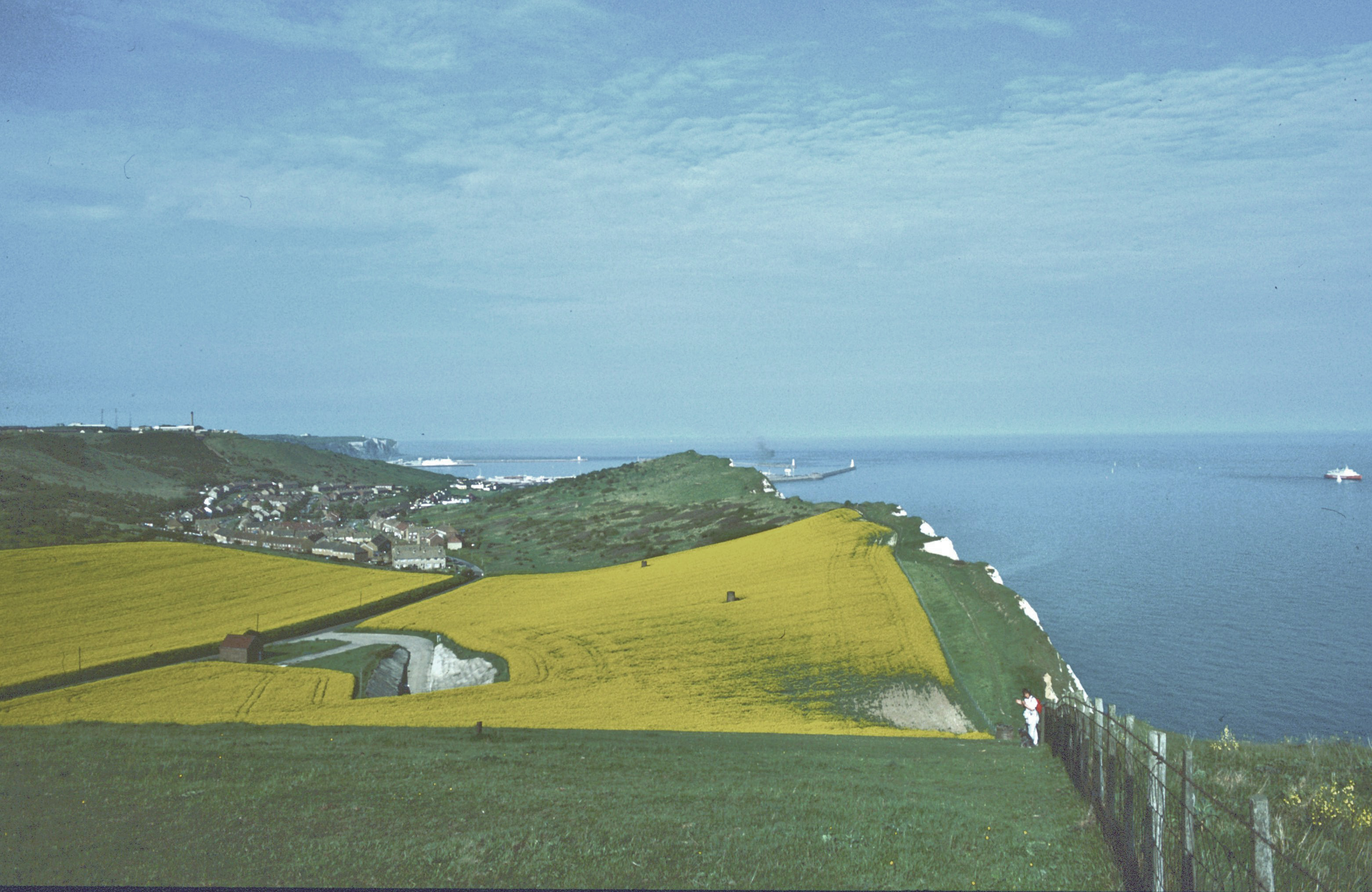
We climbed Round Down. Below us fields of rape lead to the outskirts of Aycliffe, where Rio’s ice cream van was winding through the village playing the love theme from The Godfather. Dorothy was charging along now at a terrific clip, even descending the steep east side of Round Down without assistance. Then it was up the last of the day’s climbs, Shakespeare Cliff. Views of Dover were improving all
the while and we paused for a last rest at the top, where the scene below us was most spectacular. Bertie had a last bowl of water and we plunged down the hill, even finding a paved path to take us past allotments to Sunny Corner in Aycliffe. This was the official end of the path, the end of a journey that had begun for me outside Farnham one rainy morning thirty-eight months and 180 miles earlier. Dorothy took my picture here.
I had been insisting on a leisurely pace and lots of rests today and deliberately avoiding any commitment to train times. I felt we could have a drink in a Dover pub if we had time to kill before a train departure. But now, at 6:30, I noticed that we had a chance to make the 7:10, so I lead a charge along the pavements as we walked into the town and turned north along the motorway. Bertie, on lead, was very game, for he must have been exhausted. He paused once for a green doo doo and a few pees, but kept up with me resolutely for the thirty minutes it took us to round the last corner and cross the street to Dover Priory station. Our train was just arriving at 7:00. Once seated, we pulled out the water for the dog and he made a wet mess of it on the floor. He was so overstimulated that he wouldn’t relax, visiting people in our coach and peeing once in the corridor to the Bakerloo Line at Charing Cross. We got some Turkish takeout at the Lokanta on the way home. This long day did not end until 9:30 when three weary travelers at last reached home at the end of their happy adventures.
Footpath Index:
England: A Chilterns Hundred | The Chiltern Way | The Cleveland Way | The Coast-to-Coast Path | The Coleridge Way | The Cotswold Way | The Cumberland Way | The Cumbria Way | The Dales Way | The Furness Way | The Green London Way | The Greensand Way | The Isle of Wight Coast Path | The London Countryway | The London Outer Orbital Path | The Norfolk Coast Path | The North Downs Way | The Northumberland Coast Path | The Peddars Way | The Pennine Way | The Ridgeway Path | The Roman Way | The Saxon Shore Way | The South Downs Way | The South West Coast Path | The Thames Path | The Two Moors Way | The Vanguard Way | The Wealdway | The Westmorland Way | The White Peak Way | The Yorkshire Wolds Way
Ireland: The Dingle Way | The Wicklow Way
Scotland: The Great Glen Way | The Rob Roy Way | The Speyside Way | The West Highland Way
Wales: Glyndwr’s Way | Offa’s Dyke Path
Channel Islands: The Guernsey Coastal Walk | The Jersey Coastal Walk