
August 25, 1992: Simonsbath to Lynmouth
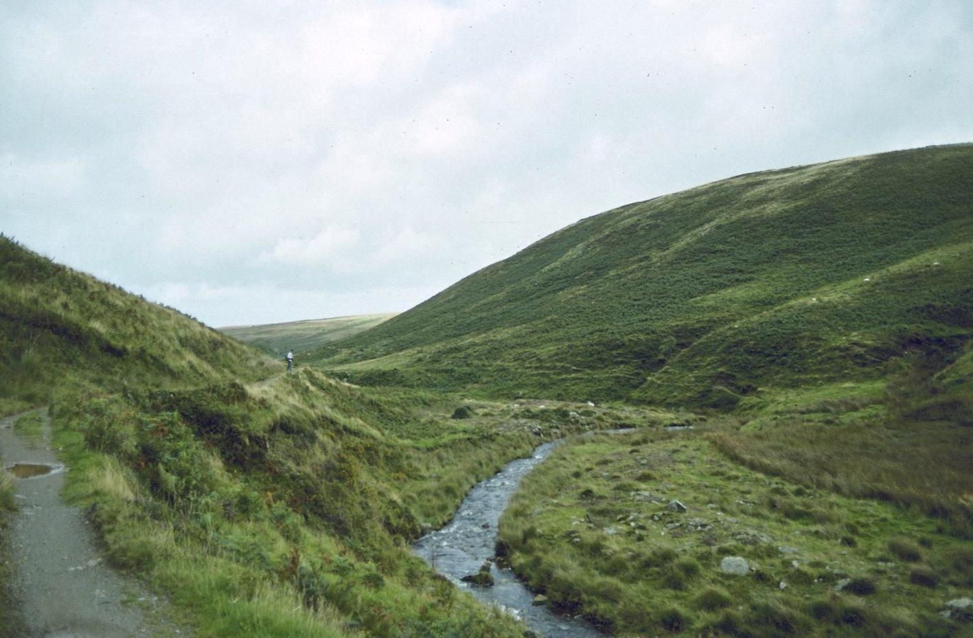
Hoar Oak Water
Already in hot water with the missus after having been away for a week, I was determined that we would make it back to London at a decent hour and so I tried to get us going as soon as possible on the morning of Tuesday, August 8 – the last day of our walk on the Two Moors Way. We were about to undertake a journey of considerable complexity.
We were down for our breakfast of scrambled eggs on toast at 8:00 and this enabled us to make the earliest start yet, an 8:48 departure from the Exmoor Forest Hotel. We rounded the corner and headed west on the B3358. Once again we were not going back directly to the spot where we had last left the TMW – but since we had made a long detour to reach Simonsbath it seemed only appropriate that we should now rejoin our route directly, following the highway west for a little over a mile.
There was considerable traffic but we had no difficulties on the verge. The day was overcast, with some signs that the sun was making an effort to appear – and at least there was no rain. It took us a while to reach open countryside again and at one point we passed through a highway tunnel made by the trees overhead. There were pleasant views of the Barle Valley on our left. After passing another set of kennels we climbed a steep hill and approached Cornham Farm, where the TMW comes in from the south. It too joins the B3358 for a few minutes.
Gavan was very quiet today. He seemed to be anticipating with some eagerness his return to Boston (and Elizabeth II) but at the same time he was unhappy that our great adventure was coming to an end and that it might be some time before we could hit the trail again. Throughout much of the day he walked well ahead of me; now he waited at our turnoff as we left the highway and headed north along a quickly deteriorating track.
There were wonderful views back down the Barle Valley behind us as we climbed up toward the skyline in the Titchcombe valley – the sky becoming ever brighter. After passing through a gate we had to make our way in a northeasterly direction over a grassy field with no path, heading for a collection of fences and gates near the source of the River Exe. Gavan did a good job of piloting us toward the corner we wanted to reach, and we had only a few more wet tussocks to climb over before reaching the first of the gates we needed to use. One could now see forward as well, and the very inviting Cheriton Ridge pointed the way north into a wonderful countryside of green fields and wooded hills. Indeed, soon we could even see the distant sea.
We followed a track heading toward the ridge but when we met a crossing track we slanted off to the left to head steeply downhill to the confluence of Long Chains Combe and Hoar Oak Water. Gavan, relying only on the OS map, questioned this decision, but now that I had the guidebook in its map case once again I was able to convince him that we were, indeed, supposed to abandon the ridge for a while. There was some concern about the level of the water in these streams, for we had some fords to cross, but we simply had to hope for the best. A little waterfall at the head of Hoar Oak Water crashed merrily behind us.
It wasn’t too hard to leap over the streams at their meeting point and we were able to take a very nice path north along the west bank of Hoar Oak Water. I found this section enchanting. The sun was out now and it gave new life to the gorse and heather that bloomed everywhere in this green corner of Exmoor. As we drew opposite Hoar Oak Tree, however, we faced the difficult problem of re-crossing the busy rushing stream at a point much too wide for leaping. We dropped steeply to the waterside but there was no ford here at all. Each of us solved the problem in his own way. I headed back up stream a hundred years or so and found a narrowing in the water that allowed me to jump across. Gavan hurled himself onto a wooden weir that spanned the water and climbed across.
We had a brief pause at a stile next to the Hoar Oak Tree (the 1916 version– which had replaced a 200 year-old predecessor). Then we climbed onto a bracken-covered hillside on the flanks of the Cheriton Ridge. I had to pause to retie my shoes several times and Gavan got quite a bit a head of me on the sheep trods that served as a path hereabouts. In the process I think he remained below the ridge top too long but when I caught up we headed uphill and soon reached the broad back of a wonderful promontory that separated Hoar Oak Water from Farley Water.
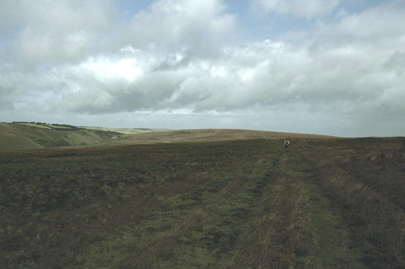
On Cheriton Ridge
In spite of a strong wind, the next mile and a half were absolutely delightful. The green fields ahead could be seen giving way to forest as valleys headed for the sea. On all sides purple heather was resplendent in the sunlight. There were quite a few people about. Gavan again got slightly off route as we neared civilization, heading in a northerly direction instead of a north-by-northwest one, and I was able to catch up with him by covering the last stages of the ridge on a more direct line – dodging the sheep droppings as I headed for an exit track out to the Cheriton Road.
Before taking this route, however, we paused for a sit-down rest and an apple. We were passed by a van full of black kids and then more came by on foot. I was struck by the rarity of the moment, a black face on the footpath.
Since the guidebook had been printed those responsible for the TMW had engineered a new right of way at this point. When I had sent away to Joe Turner for the accommodation list I had been provided with a one-page supplement that showed us how to proceed and now we used this to turn left before reaching Cheriton.
We headed west on narrow tracks heading for Scoresdown. The descent down into the Hoar Oak Valley was quite steep and much of the tarmac had been washed away – much to Gavan’s amusement. A delightful cottage welcomed us to Smallcombe Bridge. On the other side we entered a lovely tall forest, Old Wood, and continued once again in a northerly direction. But after half a mile we were driven away from the river by the grounds of Combe Park Hotel – which we had to circumnavigate. We used stiles to reach the hotel access track and the latter brought us to a junction of roads at Hillsford Bridge. It was still relatively sunny and I took off my sweatshirt. In fact there were a number of brief showers in the next hour, but we never had to don raingear.
We paused for some time at the Lodge House of Combe Park, a delightful cottage, while Gavan, posing for photographs, had a fantasy about what a cozy love nest this would make for him and the new Elizabeth. We then climbed steeply up the A33, searching for our route forward. Once again I got very close to the famous Watersmeet, the junction of Hoar Oak Water and the East Lynn River, but this was not a day for dawdling and it was well below us and I missed seeing it again.
We turned west and entered the region of the Myrtleberry Hangings. There were a number of ancient fort sites about and far ahead of us in the distance we could see, framed by the red berries of the rowan trees, Lynton and Lynmouth. The sea was now dominant as well and on the right I could see stretches of coastal scenery that I recognized from our walk of six years earlier.
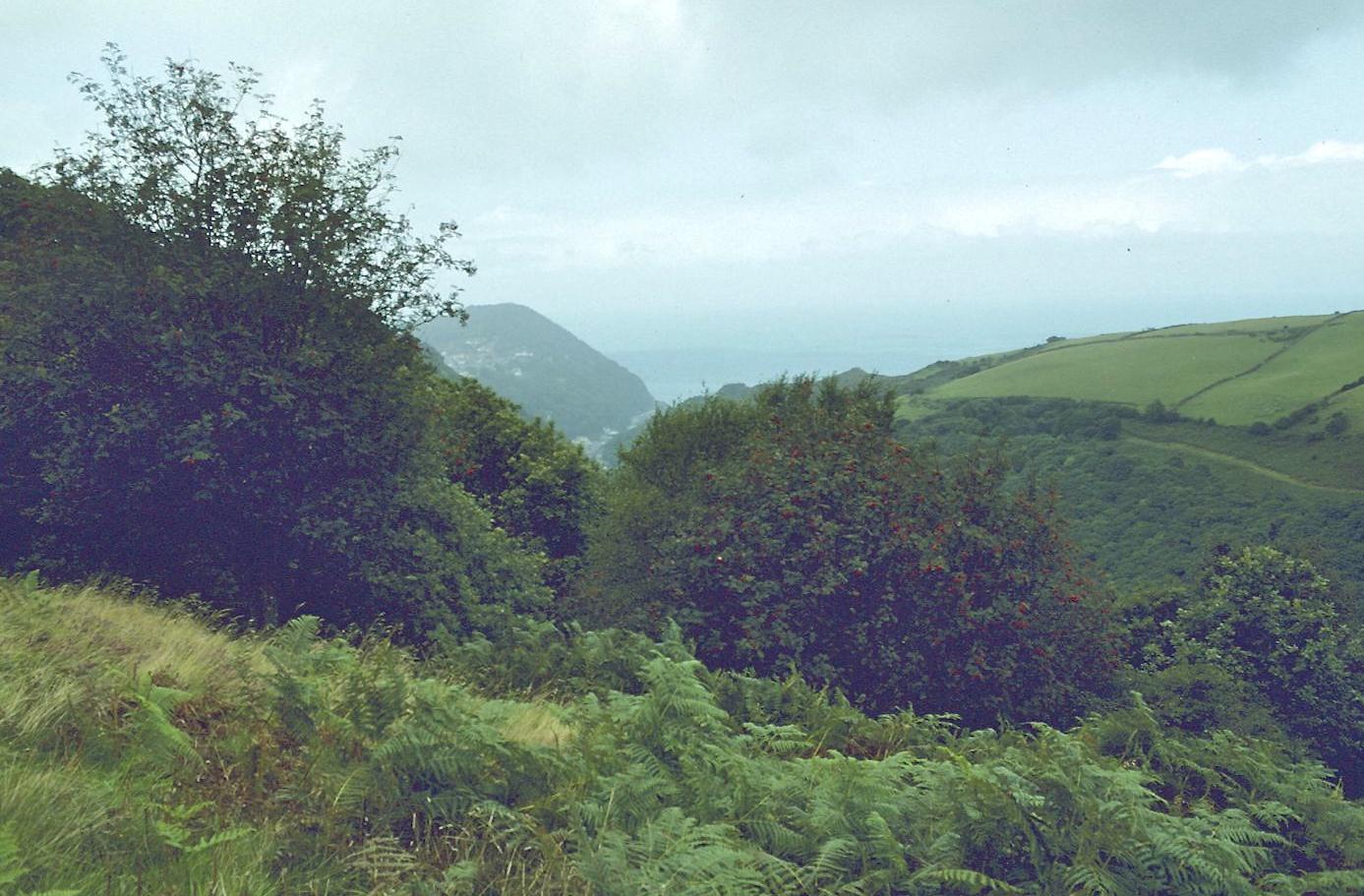
Lynton and Lynmouth from Myrtleberry Hangings
The Two Moors Way had a bit of a sting in its tail. As we neared Myrtleberry Cleave it was necessary for us to make quite a steep descent on a series of switchbacks (I could wave to the distant Gavan below me) and then we had to climb up all that distance again to Oxen Tor. There were quite a few people about, including some very ancient walkers – so this proved that it could be done. At last we un-kinked the trial and reached our final summit, walking along a fence to the top of the tor.
Now we could make progress directly toward Lynmouth below. Here I had made a 3:00 reservation for a taxi. We could see that we would make it easily, since it was just 1:00, and Gavan, speeding toward a promised pub, hurtled down ahead of me. I shouldn’t have tried to keep up because twice I slipped and fell on my backside – the only times this had happened on the trip. I wasn’t injured either time.
We ran out of path and reached a tarmac ribbon that wound through Bonnicott Wood and a number of flower bedecked cottages to reach the Watersmeet Road in Lynmouth. It was 1:45. We shook hands and posed for photos next to the TMW plinth that I had first spotted in 1986. We had walked 104 miles, an average of 13 a day.
We couldn’t spot any pubs in the vicinity of the Bonnicott Hotel (under new management) and so we dodged some traffic to walk into beautiful downtown Lynmouth itself. There was a brief shower that delayed our progress but we took shelter under an awning next to an eatery whose gray cat, Nasher (or is that Gnasher), was sitting on the sill. Tourists also slowed us down, clogging the sidewalks as they peered into the kitsch-filled windows.
We discovered a pub a last, the Village Inn, which was still open. “Not serving any food,” the pot-bellied publican shouted at us we slumped into a booth. Once again it would be nuts and crisps with our beer. Gavan then tried to pound down as much alcohol as he could in 45 minutes. I excused myself at one point to see if I could find any present for Dorothy but the wares were all appalling and I ended up only with a box of chocolates.
Time was called at the pub and, as we left, I took Gavan over to see the tramway up to Lynton. I almost got run over stepping into the street to get around the slow-moving tourists just as a car sped around a corner. Once past the pink Bonnicott Hotel we searched for a footbridge over the East Lynn to a bed and breakfast establishment – whose proprietor also ran the local taxi. We found Mr. Pile watering his glorious hanging baskets, a task he completed while the small-bladdered Gavan took the liberty of using the b&b’s loo.
We loaded our gear into the trunk of the car and left at 3:00. Gavan had been very concerned on my account because he knew of my legendary motion sickness. But he had no cause to worry now because Mr. Pile was an excellent driver. Just as well – because he began by telling us that it was a 40 minute ride to Minehead and then, when he learned we were aiming for the 3:45, added, “Well, we mustn’t wait about then,” and put his foot down.
Clear skies framed the green hills of Lorna Doone country. It was a great delight for me to see, from above, many of the sites we had walked on our first coast path expedition. We had stayed at Porlock Weir but the highway winds through Porlock village, also tourist-choked today. I could see that we would reach our destination in time and we had about ten minutes to spare when we reached the West Somerset Railway in Minehead. Gavan headed for the loo while I bought the tickets. He had completely run out of money so I was buying everything now.
We got into a seedy carriage of the old, privately-owned steam railway and sat for about ten extra minutes before we chugged away. Of course I was worried that any delay might interfere with my plans for an early arrival in London. There were a number of problem passengers – another set of mentally handicapped people being shepherded by their minders. Across from us there was a family of four, parents and two daughters, who were engaged in a raucous game – the object of which was to slap the hands of the loser. The journey was painfully slow but we at last reached Bishop Lydyard at the end of the line, at about 5:00.
Most of the passengers climbed into cars in the parking lot while we waited for a bus to Taunton Station. It took us a while for me to figure out where to stand for this vehicle. When the red double-decker pulled in the driver got off for a cigarette but I knew we had only a short ride and that we had a fighting change to make the 5:46 train. We arrived at the train station at 5:30 and I bought tickets while Gavan went to the loo. The train was a few minutes late but it was only going to make a few stops. I took a chance and, after waiting for an annoying woman to finish two phone calls, called Dorothy and got her to agree to wait and have pizza with us when we returned.
Around 5:50 we climbed aboard our train, reaching Paddington at 7:20. I decided at this point to take a cab home. After a ten and a half mile walk, a £14 taxi journey, an hour-long ride on the steam railway and two hours on the intercity I decided we didn’t need a tube ride and another ten-minute walk. By 7:30 the two tired walkers had reached our doorway, hearing for the first time in a week the hysterical barking of a lonely Schnauzer and receiving the greetings of his no-longer lonely mistress.
Footpath Index:
England: A Chilterns Hundred | The Chiltern Way | The Cleveland Way | The Coast-to-Coast Path | The Coleridge Way | The Cotswold Way | The Cumberland Way | The Cumbria Way | The Dales Way | The Furness Way | The Green London Way | The Greensand Way | The Isle of Wight Coast Path | The London Countryway | The London Outer Orbital Path | The Norfolk Coast Path | The North Downs Way | The Northumberland Coast Path | The Peddars Way | The Pennine Way | The Ridgeway Path | The Roman Way | The Saxon Shore Way | The South Downs Way | The South West Coast Path | The Thames Path | The Two Moors Way | The Vanguard Way | The Wealdway | The Westmorland Way | The White Peak Way | The Yorkshire Wolds Way
Ireland: The Dingle Way | The Wicklow Way
Scotland: The Great Glen Way | The Rob Roy Way | The Speyside Way | The West Highland Way
Wales: Glyndwr’s Way | Offa’s Dyke Path
Channel Islands: The Guernsey Coastal Walk | The Jersey Coastal Walk