
October 17, 1987: Hathersage to Bakewell
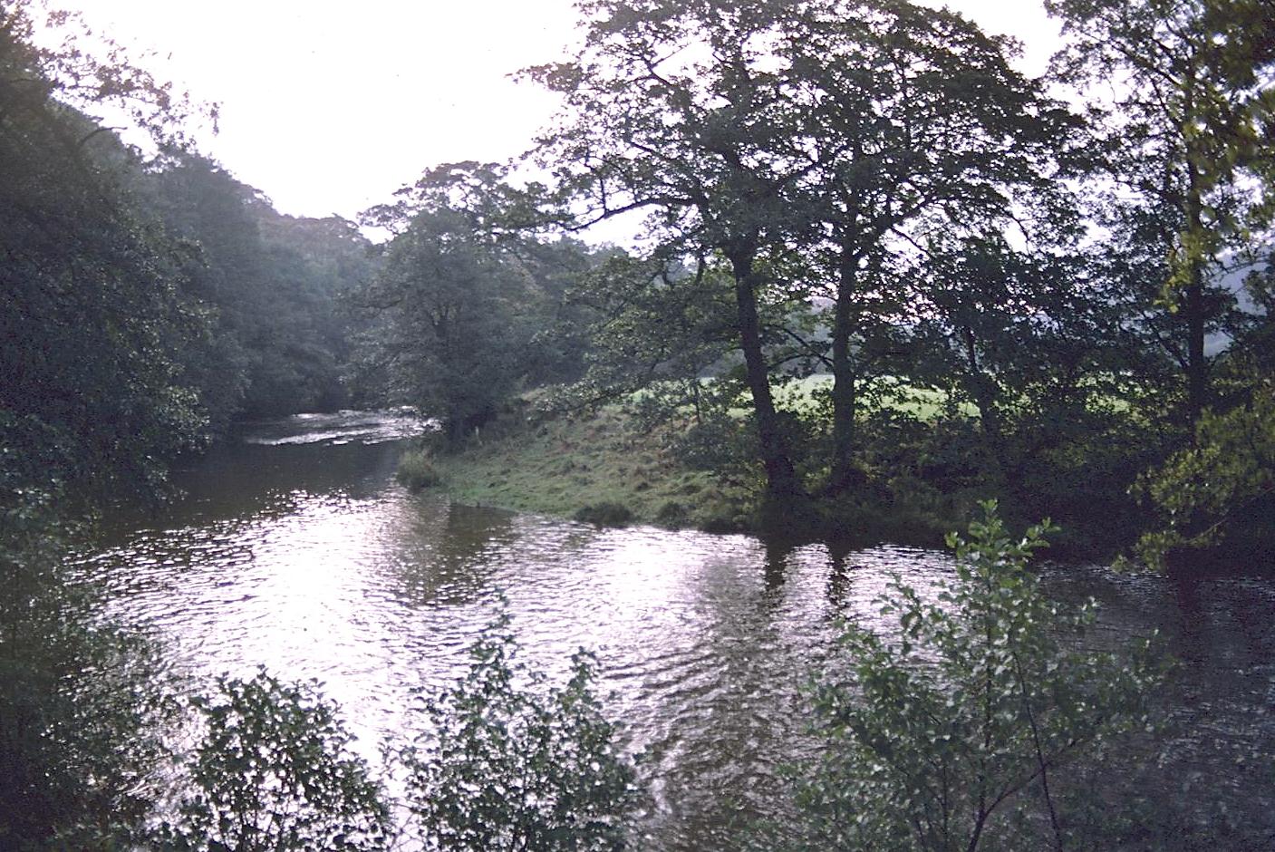
The Derwent near Harper Lees
I slept well, but some of the lads reported that they had been cold as we arose for our last day of walking on Saturday, October 17. I do recall that Doug lost his blanket at some time during the night and managed to retrieve it from the floor without getting out of the top bunk. The munchkins were somewhat slower to rise than the rest of us and we hurried through our packing preparations at 7:15 in order to beat them to breakfast at 7:45. I had time to shave and retrieve my boots from the main building before we sat down to our meal. How gratifying to see everyone at table. With some rather easy chores to get out of the way we were ready to depart at 8:55! I wanted an early start for our longest day (twelve and a half miles), but I can’t remember ever getting a school group launched this early before.
It was a nice morning, somewhat cool but without the threat of immediate rain. Better weather, including some sunshine, seemed to be heading our way from the west. We retraced our steps through Hathersage, encountering far fewer traffic problems at this hour, and headed back downhill under the railway overpass to the riverside. Instead of crossing to the far bank we took a private road to Harper Lees, one that accompanied the Derwent on the left bank. It was a lovely fall morning, with misty patches hanging over the river, the trees showing their autumn colors, and the birds in song.
When the track ended at Harper Lees we continued ahead over wet grass and followed the river on paths and tracks through woodland and open stretches for the next two miles. Jenny Frost was still limping along uncomplainingly on her tree limb and, using a technique I remembered from my stepfather’s arsenal, I made Jenny go first – striking a comfortable pace with Dina and Chris side by side. She kept stopping to adjust her borrowed boot, which was digging into her ankle uncomfortably, and I was really beginning to wonder if we were going to have to leave her somewhere on route and pick her up with our bus later in the day. At this point Chris had a brilliant idea. She dug out her extra pair of tennies and offered these to Jenny. Not only did they fit, but they avoided contact with the bruise on the ankle. With her own boots hanging from her pack she strode forward comfortably for the rest of the day. Out of loyalty to an old friend she continued, however, to carry her stick.
I sent Mike Messner ahead to confirm a bridge over Burbage Brook. While he was doing this Dina discovered that some of the lads had hidden a large rock in her pack this morning; she had been carrying it for over an hour. After the screaming there were some choice words for Doug Gibb – whom she unerringly identified as the perpetrator. We then followed a hedge along a wet path until we could see the hamlet of Grindleford Bridge. Our instructions required us to head up a track opposite the petrol station and I scouted this out (and took a picture of the church hidden by its avenue of yellow-leaved trees) while the tail caught up. Then, making excellent time, we followed our track uphill away from the river. The boys took it a bit too far, into a farmyard, but I called them back to cross a stile and began a woodland path straight uphill. We paused several times and once we felt drops – perhaps coming only from wind in the trees. In fact the heavens were getting brighter all the time and there was much blue sky and sunshine as we neared the top of Froggatt Edge. The boys waited at a crossing track, as instructed, but I decided we were not near the summit, and that we needed to go even higher (“Mr. Linick…!”). Sure enough we came across the right track a moment later; on this we stood gasping for air until it was time to move in a southerly direction out onto an open moorland that brooded over the millstone outcroppings on our right. Below us there were magnificent views of the Derwent Valley.
We had to ford a stream and climb up to a motor road. Ahead of us there were dozens of climbers laden with ropes heading for a morning on the cliffs. Mixed in with them was a contingent of geriatric walkers on a Saturday outing – it was the first time that we had encountered other users of our route in any numbers. Indeed the lovely weekend weather attracted a large number of people to the heights today.
Tosh was agitating from the rear for a rest stop, but I didn’t wanted to plunk down in the equivalent of a trailside Grand Central Station. I told my frontrunners to stop at the first sunny off-trail spot with a view and in a few hundred yards they had occupied a large rock outcrop with wonderful views over the valley. We dived into our lunches here (I finished yesterday’s lunch), resting some fifteen minutes before the cool breeze pushed us forward once again.
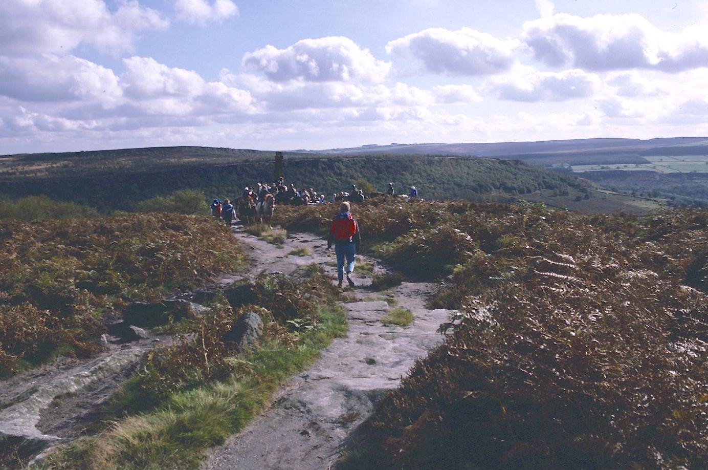
There now followed a wonderful march along the top of Froggatt and Curbar Edges, with views of the valley on our right and the last pink of a heather moor on our left. There was an excellent path, not too wet, and rising and falling gently for almost four miles. Our people tended to spread out a bit on this stretch; it was hard to keep everyone in sight because of the traffic: every variety of walker, casual strollers and their dogs, infants in arms and toddlers trying out their first wellies in the puddles. My dog Toby would have loved this stretch.
Approaching the Wellington Monument
When Tosh again demanded a rest stop I suggested a rendezvous at the Eagle Stone, a rocky nub of a pillar standing by itself on the moor top some half a mile distant. We all headed for it and some of the lads made an unsuccessful attempt to climb it. We then had a second snack in the sunshine and moved on just a few hundred yards to the Wellington Monument, a modest cross at the end of the moor. There were riders about here and the geriatric walkers (if this was the same group) had started up their own picnic. I was now looking for the beginnings of a track that would take us down from this height and into the village of Baslow. I found it without much difficulty and we began our descent.
At the last set of farm buildings before returning to civilization some friendly horses poked their noses over the fence, hoping for a handout. While these animals were munching our YHA apples we were approached by a small army of delightful kittens. The kids went crazy for these little grey characters and followed them into the farmyard where the adult members of this family were sunning themselves on top of some chicken houses. It took a long time for us to say goodbye and I wondered if I should search knapsacks for any stray kittens. Greg explained that their “Princess,” having demonstrated unmistakable male characteristics, had been renamed “Princeton.” This made Kerry nostalgic for some of the lost cats of her youth.
I was in no hurry, for we had been making excellent time and I didn’t want to put us in Bakewell with nothing to do. We entered Baslow village and continued downhill until just opposite the church and the Duke of Devonshire. Here we occupied some tables in the sun, it being warm enough to sit outside today, and had lemonade and other soft drinks. Then I lead us on a big circle, through the churchyard, out to an ancient toll both onto an old bridge over the Derwent, across the bridge, along a back street (where there was a car bought at an agency named Adam Bede), out to the main highway, back across the Derwent on pavement, and around the corner toward the Cavendish Hotel.
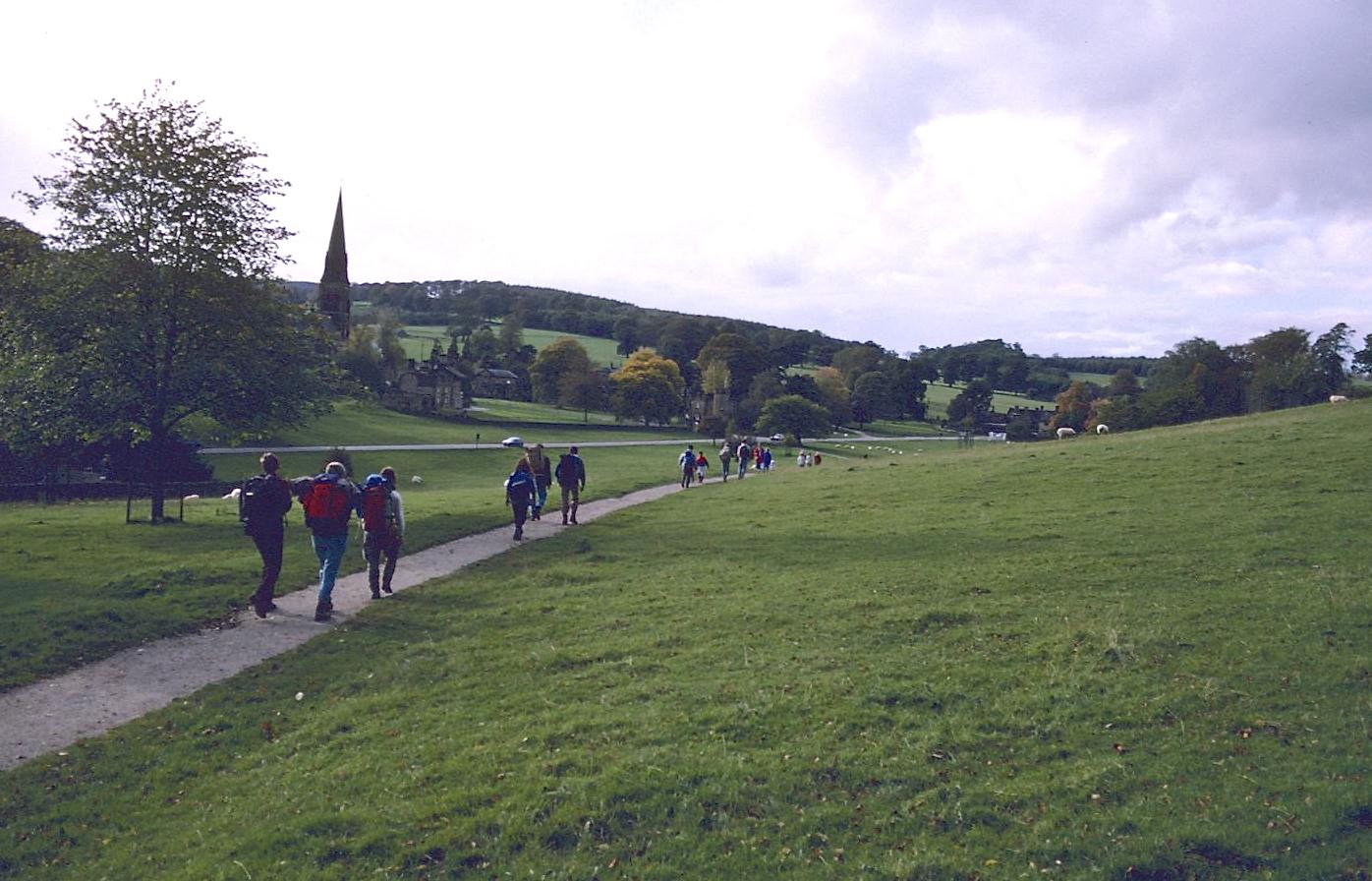
We now found a set of steps putting us on a path that crossed a stream and joined a wide track that lead into the grounds of one of England’s most famous stately homes, Chatsworth. Fortunately the entrance booth was closed but there were dozens of people milling about as we all had to use the same narrow kissing gate. I could see the Hunting Tower in the woods above and ahead of us a fountain was spurting into the skies. I had no intention of taking a tour here but I thought we might scare up an ice cream. Tosh and some of the girls preferred to rest on the lawn in front of the impressive house while the rest of us walked up the drive without our packs. Everyone used the loos and we bought candy in a gift shoppe, but there wasn’t any sign of ice cream unless you count the sign that that said you couldn’t bring it into the gift shop. A crabby lady who refused to make change for anyone was in charge here. I disdained all the overpriced kitsch.
Edensor
We walked back to the rest of our party and crossed the attractive bridge to begin a short climb over the little hill that faced Edensor village. I had some route-finding problems here (the only time on the trip). We got up opposite the church (where JFK had visited the grave of his sister in 1963), but the turnoff from the road that climbed up from the church eluded me. Part of the problem was the large number of frontrunners who had charged well past the turnoff by the time I caught up with them. I was now convinced that we were heading west instead of southwest and I ordered a retreat – which they accepted without complaint. We had to return almost to the church, where I discovered some steps hiding in the shadows. These gave us access to grassland again and we began a quite steep climb up to the forested top. There was no evidence of a path but I had Richards’ maps too and these helped me with some landmarks. The kids were told to wait at the gate into the forest and here we all rested for a while after our climb.
The views, which included this morning’s edges and Chatsworth itself, were magnificent and it was hard to tear oneself away. The ground on which we had plopped was a bit damp so perhaps it was time that we got a move on. I had slowed us down so that it was now 4:00 and we had a little over two miles to go to meet our 5:30 rendezvous in Bakewell.
I was glad I had Richards’ maps because these last two miles were trickier than expected and I had to pause several times for compass bearings. We cleared the forest and peeked around a corner to see a Russian-style cottage that some Chekhov fan had decided to build in Derbyshire. Then, at a crossing track, we headed west, still moving uphill, climbing a stile and searching for a pond hidden in the grass. Opposite it the kids discovered a grass covered water bubble that they jumped on and poked at until a gusher was produced (I assume Chatsworth escaped flooding that night). I had to be very careful which stiles to cross in order to begin my descent to Bakewell – in fact we had to clear two as we left the pond. Then I needed a bearing as we headed downhill, with a promised hut coming into view as reward. A few of the kids were getting anxious about missing our bus, but I wasn’t worried.
We had to make a steep descent through woodland, with a number of paths to choose from, before emerging on a golf course that overlooked Bakewell. What a feeling of satisfaction to see the place again, the sun sinking before us at the end of a perfect autumn afternoon. We waited for a while on the course for everyone to catch up and then continued our descent. Part of the time we had been following the markings of a local footpath but when we got to a viaduct the latter called for a descent and after a few steps I decided that this was not the White Peak Way. So we retreated (except for the energetic Doug) and crossed the bridge to continue on the same line down to the road and into the local sports ground.
There was something familiar about the buildings hereabouts for we had rejoined the Wye-side path that we had taken in the first minutes of Day 1 a year ago. The circle was complete. I took a picture of everyone crossing a little bridge and Tosh, Paul, and I were photographed on the completion of the entire White Peak Way. It was 5:20 as we reached town centre. Tosh dashed into a bakery for some Bakewell puddings (much better than last year’s) and I went searching for a loo. The kids stood at the bus shelter (from the awning of which several local skateboarders were hanging) and waited just a few minutes before Mr. Sutton came around the corner. He loaded all our packs into the back of his bus and we were off to Chesterfield.
I was quite tired and sat with Tosh in the middle of the bus as a way of escaping extra chatter from our driver. There was a traffic slow-down that had me worried for a while, the result of road works that reduced the highway to a single signal-controlled lane, but things improved eventually. We drove back through Baslow and up to the top of the Edge again before beginning a descent into Socialist Chesterfield with its famous crooked church tower. We arrived at the station at about 6:15. Before everyone scattered I told them to remain seated for just a moment while I told the kids how proud Tosh and I were of everyone’s behavior and how much we, the sponsors, had enjoyed the walk. These feelings were reciprocated. I sent Tosh in to make sure of our departure time so that kids could call parents in London. I settled up with Mr. Sutton, who had forgotten what he had said he would charge us, and came in from the cold.
Everyone was using loos, getting hot drinks from a magic machine, and phoning parents and I was left to guard the packs in the waiting room and brood about an announcement about delays on the line. It appeared that we would luck out: the hurricane that had done so much damage in the London area had affected the Southern Region especially, but the way back to St. Pancras was unblocked. The last pack was claimed and I entered the platform, leaving behind only Jenny’s forlorn and now unneeded walking stick. I bought a coffee from the machine and burned my fingers with the brew as I crossed under the line to rejoin the others on a cold trackside platform. Greg and I argued about which end of the train would have our Car B; he said it would be the front, I the rear. This meant he and his friends had farther to run when the 6:43 showed up and B was at the rear. At Derby, however, the train reversed directions, making everyone happy.
We occupied the same reserved seats as before. I couldn’t get the West Indian guard to note (as his counterpart had done on the outward journey) that we were one student light – Mike Messner travelling on his own ticket at this point. There was more bad news. The buffet car was not open. I emptied my pack and produced a collection of oranges, crisps, biscuits and candy bars that were soon gone. The kids chattered for the two and half hours of the trip (we were a little late); Mike and I played another version of Categories. Many of the students came forward to express their thanks (something many kids on other Alternatives neglected to do). As we departed shortly after 9:00 I kissed all the girls goodbye and shook hands with all the gents. There were a few parents about.
Mike Messner, who lives on Randolph Avenue, accompanied me on the tube home. Once again I was tapping through the streets with my own walking stick, a happy tattoo after a most successful outing. Two weeks of bronchitis were probably the result of some viral infection having nothing to do with the walk. Somehow I couldn’t get Dorothy to agree with this thesis.
Footpath Index:
England: A Chilterns Hundred | The Chiltern Way | The Cleveland Way | The Coast-to-Coast Path | The Coleridge Way | The Cotswold Way | The Cumberland Way | The Cumbria Way | The Dales Way | The Furness Way | The Green London Way | The Greensand Way | The Isle of Wight Coast Path | The London Countryway | The London Outer Orbital Path | The Norfolk Coast Path | The North Downs Way | The Northumberland Coast Path | The Peddars Way | The Pennine Way | The Ridgeway Path | The Roman Way | The Saxon Shore Way | The South Downs Way | The South West Coast Path | The Thames Path | The Two Moors Way | The Vanguard Way | The Wealdway | The Westmorland Way | The White Peak Way | The Yorkshire Wolds Way
Ireland: The Dingle Way | The Wicklow Way
Scotland: The Great Glen Way | The Rob Roy Way | The Speyside Way | The West Highland Way
Wales: Glyndwr’s Way | Offa’s Dyke Path
Channel Islands: The Guernsey Coastal Walk | The Jersey Coastal Walk